A set of decorative stones adorning a column, with airport signage shown in the reflection.
I’m traveling again this week (4 weeks of travel in a row!), so today I’m sharing another picture of some “airport geology”. Specifically, this is a picture of some gorgeous decorative stones adorning a column at O.R. Tambo International Airport in Johannesburg, South Africa. I took this picture yesterday when I was passing through the airport. I particularly like the way the block of rock was split and the set up in a symmetrical fashion to enhance the effect of the natural patterns in the rock. There are quite a few similar sets of decorative stones around the airport — they adorn many support columns throughout the airport.
O.R. Tambo is full of gorgeous decorative stones. Last week I shared a shot of part of the floor.
Lovely decorative stones adorning the airport floor, with my feet for scale.
I travel a lot for my job, and I often find myself traveling through O.R. Tambo International Airport in Johannesburg, South Africa. The terminal buildings contain some lovely decorative stones, which I often admire as I’m navigating my way through the airport. For example, while I was waiting for my luggage today I admired, as I have before, some of the lovely decorative stones that make up part of the floor in the domestic baggage claim area. These stones really are gorgeous, as you can see in the above picture. Check out all of the different hues: pink granitic rocks, gray gneiss rocks, dark black rocks (gabbro, perhaps?), and lovely yellow rocks (another type of igneous rock) — a rock rainbow of sorts! What rock types do you spot?
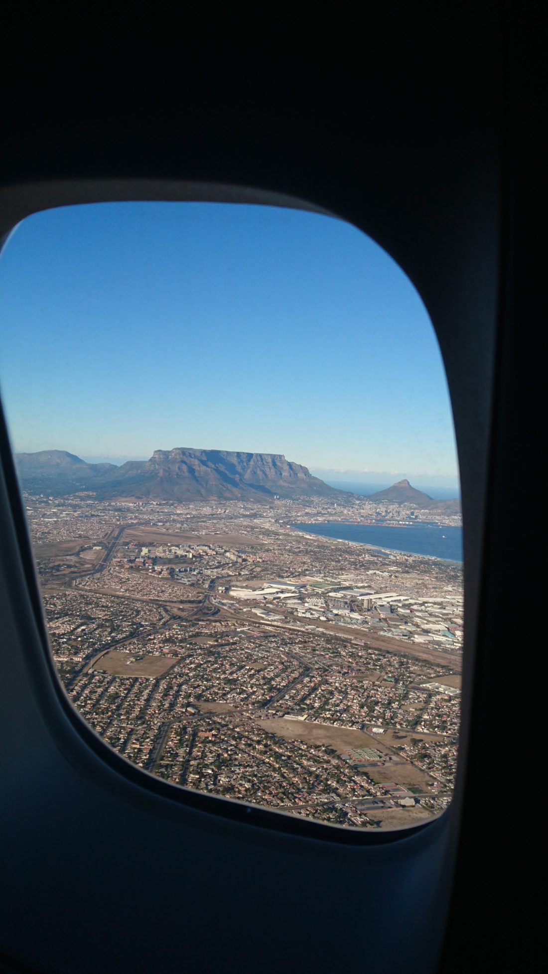
Yesterday morning I flew back to Cape Town after a business trip. I arrived a little after 7 am and was treated to a stunning view of Table Mountain and Lion’s Head as I flew in. I’m sharing a picture I snapped of that view as this week’s geology picture. Here’s a closer look as well:
A closer look at the mountain.
I am lucky to live in such a beautiful city! However, you can see that the city is looking somewhat brown and dry, due to the drought and water restrictions. No one is watering their gardens!
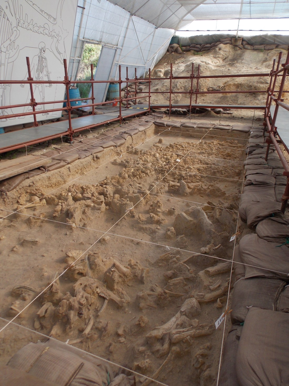
Today I’m sharing a picture of some Pleistocene age fossils that are on display at the West Coast Fossil Park, which is located about an hour’s drive north of Cape Town, South Africa. If you ever find yourself in the area I highly recommend a visit to the park.
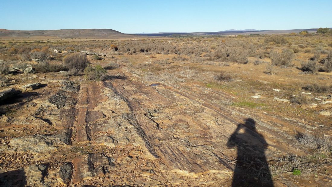
Today I’m continuing with my recent theme of blogging about glacial pavements, and I’m sharing a picture of me sitting on top of a glacial pavement at Nooitgedacht, which is near the town of Kimberley in South Africa. I’ll share more pictures and information about this pavement soon. For now, however, you can read a little about the pavement on Wikipedia here. Although this pavement is located about 700 km away from the pavement at Oorlogskloof (which I blogged about recently), it was carved by the same 300 million year old Dwyka glaciation!
Gorgeous glacial pavement, with sunglasses for scale.
Last week I shared the above picture of the Oorlogskloof Glacial Pavement for my “Monday Geology Picture” series.
Today I’d like to share some more pictures and also a little more information about this incredible geologic site.
Oorlogskloof is the name of the farm where the glacial pavement is located. The name is Afrikaans and translates as “War Valley”. Oorlogskloof is located about 4 hours drive north of Cape Town, South Africa, near the town of Nieuwoudtville.
The glacial pavement is about 300 m wide and 140 m long. On the pavement, you can see impressive glacial grooves that were carved by Dwyka glaciers 300 million years ago. A fence protects the site, which is a short distance off the road. A nice information sign has been put up, with explanation both in Afrikaans and in English. There is even a road sign that reads “Glacial Pavement” – now that’s not a road sign that you see every day!
Information sign, with both Afrikaans and English text.
Close-up of the English text.
Close-up of the geologic figure.
Road sign!
In addition to the information sign, the South African Council for Geoscience has prepared a wonderful guide to the site. You can download it here.
An excerpt from the guide is:
About 300 million years ago, glacial conditions
prevailed over Southern Africa when it migrated with
the rest of the Gondwana supercontinent over the
South Pole. The ridges and striations in the sandstone
at Oorlogskloof formed as a result of ice movement
during this time.
The grooves were not made on bedrock, but in a thin
layer of sandy debris trapped between bedrock and
the glacier base. This veneer of glacial detritus, which
was eroded from sandstone bedrock and carried
along by the ice, is preserved as a pebbly quartzose
sandstone. The grooves were made by rock and
pebbles held in the ice.
Please go and read the rest of this excellent guide.
Here are some more pictures of the spectacular glacial grooves:
A closer look at some grooves, with sunglasses for scale.
Grooves…
…grooves…
…grooves…
…and more grooves!
A slightly closer view, with sunglasses for scale.
Grooves, with foot for scale.
Another view with a foot for scale.
A stunning landscape view.
If you find yourself in South Africa, I highly recommend a visit to the glacial pavement. It’s worth the 4 hour drive from Cape Town, and you’ll see some spectacular geology on the way as you drive through the Cape Fold Belt. The general scenery in the area is also very beautiful.
This week I’m sharing a picture of a bullion coach, or a special train that was used to transport gold from the mines in the Johannesburg area to the seaside towns of Durban and Cape Town in South Africa. This particular train is on display at Gold Reef City, a gold mining themed amusement park. You can go and see the train yourself if you visit the park.
Gold theft has long been a problem in the mining industry — and continues to be a problem to this day. Trains such as this are not used anymore (at least not here in South Africa), but for many years heavily fortified trains such as this were the primary way that gold was transported. In addition to the special armor, the train had several guards who lived aboard the train.
Look at the thick doors of the train and the special safe used to store the gold:
Posing with the thick doors of the train. These pictures were taken last year when I was 7 months pregnant with my son.
Gorgeous glacial pavement, with sunglasses for scale.
This week I’m sharing a gorgeous picture of the Oorlogskloof Glacial Pavement, which is located in the Northern Cape Province here in South Africa. You can read more about this pavement here. I’ll be blogging more about this pavement soon, so stay tuned!
Lion’s Head. Photo taken from Sea Point Promenade, November 2017.
Happy New Year! I’m going to do my best to blog more regularly in 2018, starting with this first “Monday Geology Picture” post. This week I’m sharing a view of Lion’s Head (the distinctive mountain in the background of the picture), an inselberg here in Cape Town, South Africa, the city where I live. I took this picture a few weeks ago during a walk with my family along Sea Point Promenade. Cape Town is a fantastic city — you can see amazing geology even when you’re downtown!
For this week’s “Monday Geology Picture”, here’s a snap of a mine cart filled with kimberlite rocks — and a mantle xenolith or two. I took this picture last year when I visited The Big Hole Museum in Kimberley, South Africa. The rock kimberlite was named after the town of Kimberley, of course! For those who are unfamiliar, kimberlite is the ore that is mined for diamonds, and many of the early diamond mines in South Africa were located in the vicinity of Kimberley. One of those old mines, which is called The Big Hole or Kimberley Mine, has been turned into a museum. The museum is well worth visiting if you find yourself in this part of South Africa.
Here’s a closer view of some of the rocks in the cart: