Today I’m continuing with my recent theme of blogging about glacial pavements, and I’m sharing a picture of me sitting on top of a glacial pavement at Nooitgedacht, which is near the town of Kimberley in South Africa. I’ll share more pictures and information about this pavement soon. For now, however, you can read a little about the pavement on Wikipedia here. Although this pavement is located about 700 km away from the pavement at Oorlogskloof (which I blogged about recently), it was carved by the same 300 million year old Dwyka glaciation!
Gorgeous glacial pavement, with sunglasses for scale.
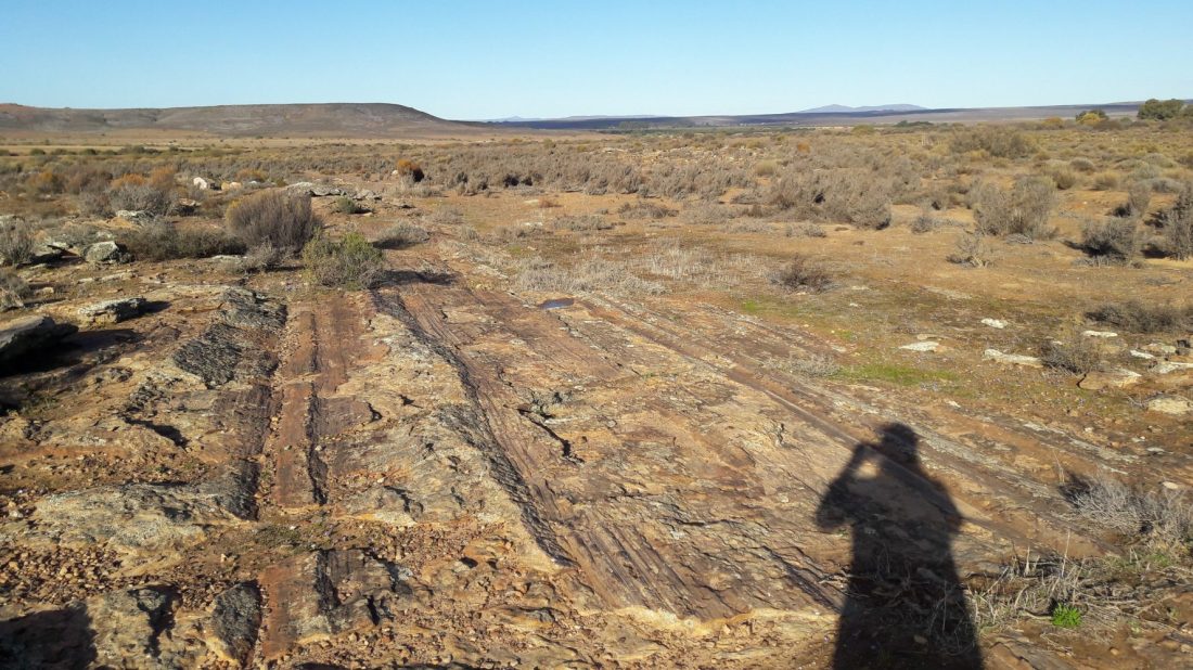
Last week I shared the above picture of the Oorlogskloof Glacial Pavement for my “Monday Geology Picture” series.
Today I’d like to share some more pictures and also a little more information about this incredible geologic site.
Oorlogskloof is the name of the farm where the glacial pavement is located. The name is Afrikaans and translates as “War Valley”. Oorlogskloof is located about 4 hours drive north of Cape Town, South Africa, near the town of Nieuwoudtville.
The glacial pavement is about 300 m wide and 140 m long. On the pavement, you can see impressive glacial grooves that were carved by Dwyka glaciers 300 million years ago. A fence protects the site, which is a short distance off the road. A nice information sign has been put up, with explanation both in Afrikaans and in English. There is even a road sign that reads “Glacial Pavement” – now that’s not a road sign that you see every day!
Information sign, with both Afrikaans and English text.
Close-up of the English text.
Close-up of the geologic figure.
Road sign!
In addition to the information sign, the South African Council for Geoscience has prepared a wonderful guide to the site. You can download it here.
An excerpt from the guide is:
About 300 million years ago, glacial conditions
prevailed over Southern Africa when it migrated with
the rest of the Gondwana supercontinent over the
South Pole. The ridges and striations in the sandstone
at Oorlogskloof formed as a result of ice movement
during this time.
The grooves were not made on bedrock, but in a thin
layer of sandy debris trapped between bedrock and
the glacier base. This veneer of glacial detritus, which
was eroded from sandstone bedrock and carried
along by the ice, is preserved as a pebbly quartzose
sandstone. The grooves were made by rock and
pebbles held in the ice.
Please go and read the rest of this excellent guide.
Here are some more pictures of the spectacular glacial grooves:
A closer look at some grooves, with sunglasses for scale.
Grooves…
…grooves…
…grooves…
…and more grooves!
A slightly closer view, with sunglasses for scale.
Grooves, with foot for scale.
Another view with a foot for scale.
A stunning landscape view.
If you find yourself in South Africa, I highly recommend a visit to the glacial pavement. It’s worth the 4 hour drive from Cape Town, and you’ll see some spectacular geology on the way as you drive through the Cape Fold Belt. The general scenery in the area is also very beautiful.
Gorgeous glacial pavement, with sunglasses for scale.
This week I’m sharing a gorgeous picture of the Oorlogskloof Glacial Pavement, which is located in the Northern Cape Province here in South Africa. You can read more about this pavement here. I’ll be blogging more about this pavement soon, so stay tuned!
Fox Forest #1. Trees and glacial erratic boulders.
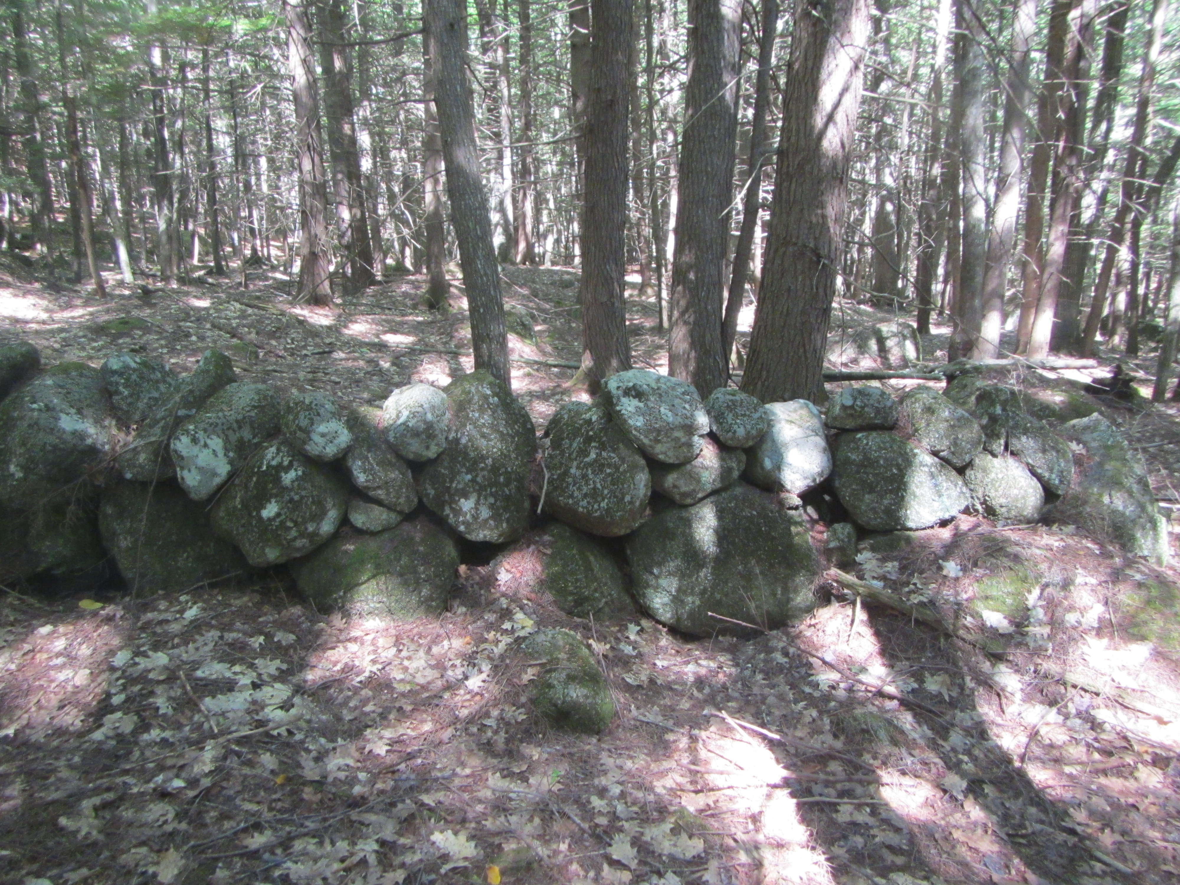
For this week’s Monday Geology Picture I shared a picture of a stone wall incorporating a large glacial erratic. I took this picture recently in Fox Forest in southern New Hampshire. Yesterday, my husband and I went on a lovely hike in the forest. We saw quite a few glacial erratics… parts of the forest are piled high with them! We also saw many stone walls incorporating glacially dropped stones. Most of the forest is relatively young and grew up over the past hundred years or a little less on top of former farmland. You thus see old stone walls, the outlines of former fields, throughout the forest. You can also see old building foundations and even an old cemetery. A few parts of the forest are “virgin” and contain older trees, including some that are hundreds of years old. All in all, I recommend a walk in the forest. You can see some glacial geology… and learn about the trees and other vegetation, too!
I thought I’d share a few more pictures of our hike yesterday. If you want to read more about glacial erratics and stone walls in New England, I highly recommend this Earth Magazine article. Thanks to AGI for recommending the article to me on Twitter!
Without further ado, here are some more pictures from lovely Fox Forest:
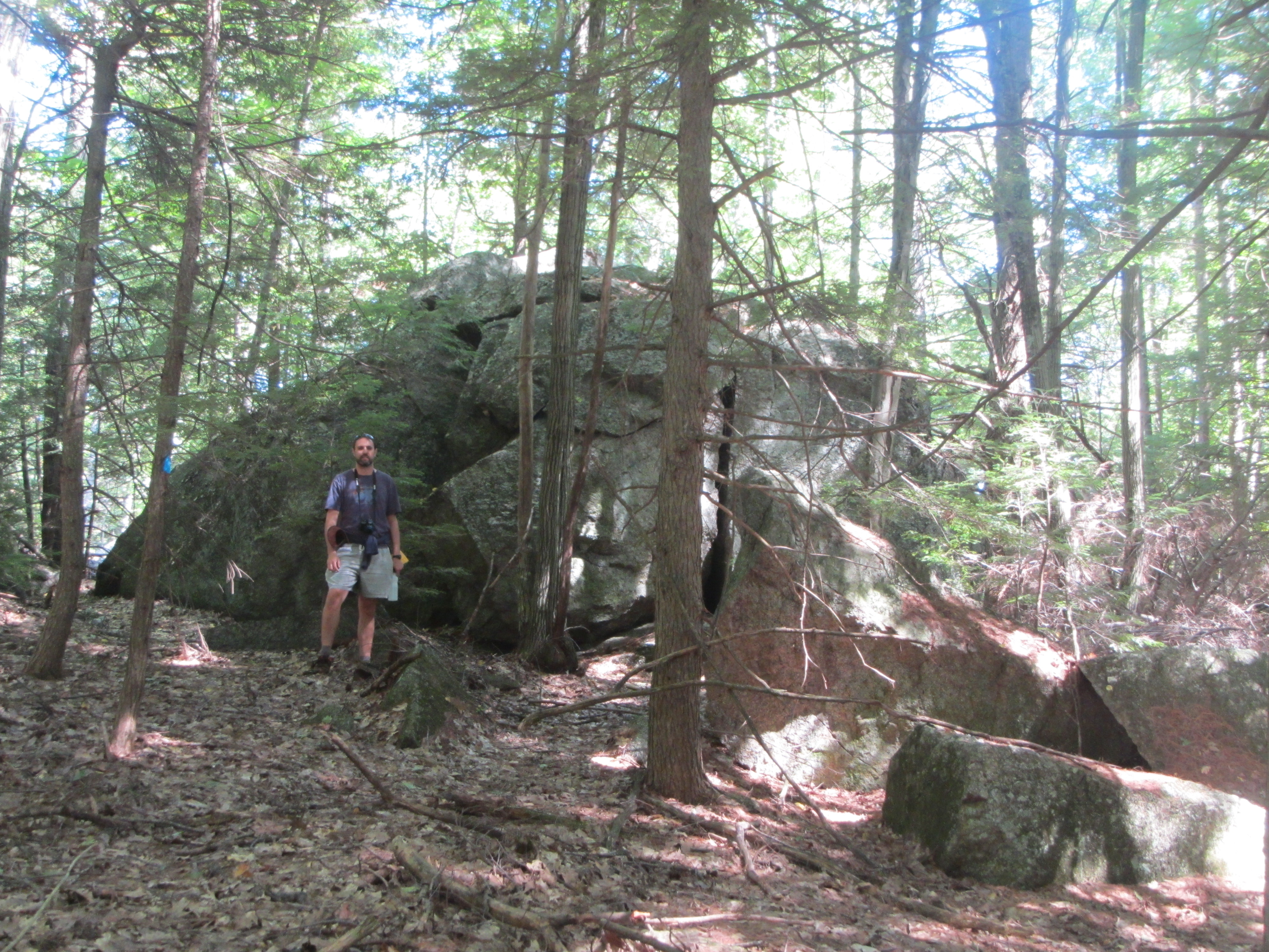
Fox Forest #2. More glacial erratic boulders and trees.Fox Forest #3. A glacial erratic boulder, with geologist on top for scale.Fox Forest #4. Erratics, erratics everywhere!Fox Forest #5. Moss-covered erratics and some ferns.Fox Forest #6. A stone wall made out of glacial erratics.Fox Forest #7. A closer view of the stone wall.Fox Forest #8. A long stone wall running through the forest.Fox Forest #9. A stone wall incorporating a very large erratic boulder.Fox Forest #10. An old cemetery in the middle of the forest.Fox Forest #11. Cemetery headstones.Fox Forest #12. A fallen headstone, in the process of being restored.Fox Forest #13. Another large erratic boulder, with another geologist for scale.Fox Forest #14. Another stone wall.Fox Forest #15. Fading afternoon light in the forest, near the entrance to the hiking trail.
A stone wall incorporating a large glacial erratic boulder, Fox Forest, New Hampshire.
Continuing with my recent blogging themes of stone walls and glacial erratics, here is a picture of a stone wall in Fox Forest in New Hampshire. This stone wall was built out of glacial erratics and incorporates a large glacial erratic that was most likely left in situ… that is, left more or less where the glacier deposited it. Today, the stone wall is located in the middle of a relatively young forest. A hundred or so years ago, it was part of a farm. If you find yourself in southern New Hampshire, I recommend a hike in Fox Forest. It’s a lovely place, and you’ll see quite a few glacial erratics and stone walls!
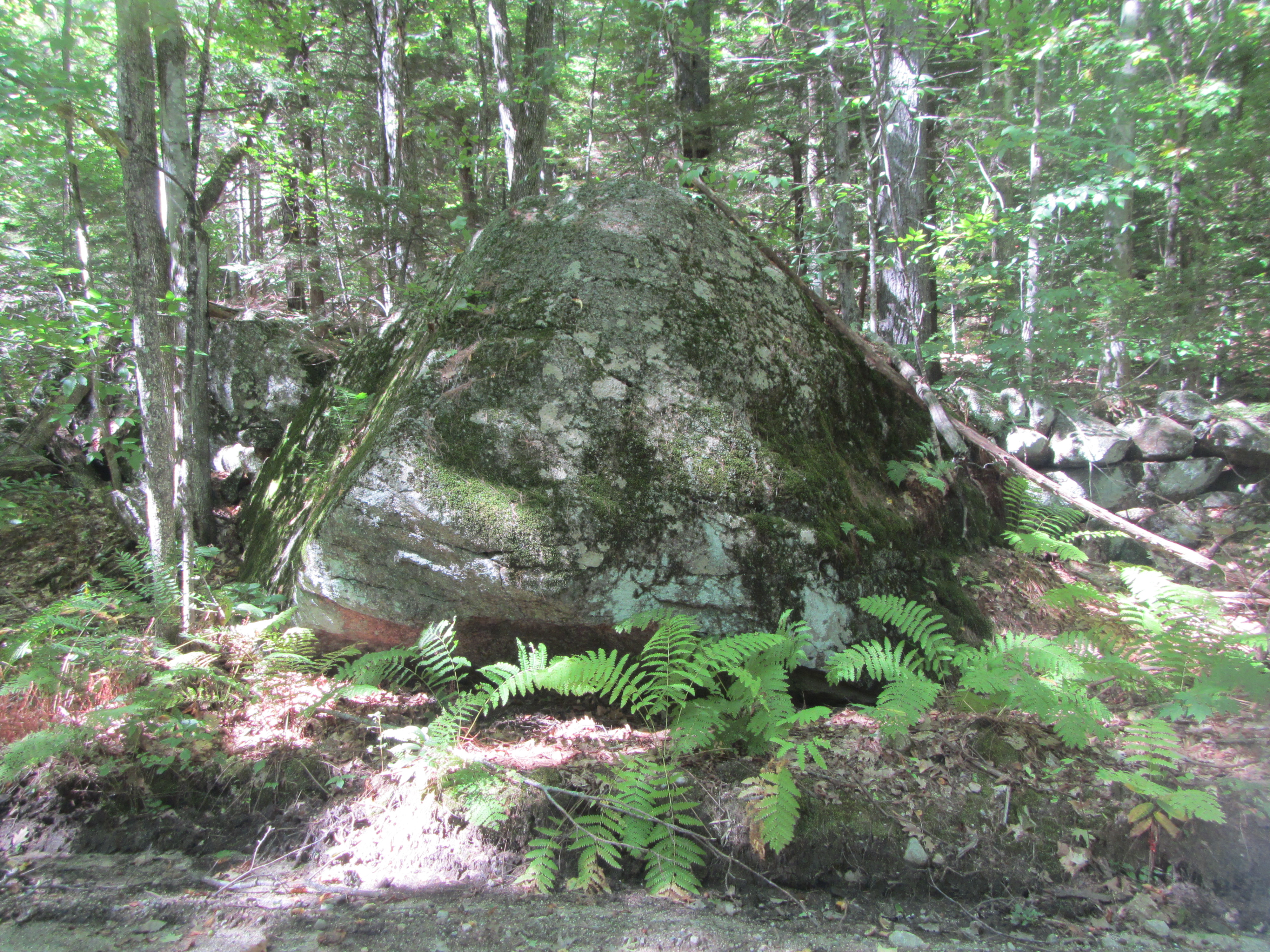
I’m visiting family in New Hampshire at the moment… and also spending a little time with my favorite glacial erratic. I’ve posted about this particular glacial erratic before here and here. For this week’s Monday Geology Picture post I thought I’d share another shot of this stunning glacially deposited boulder. Enjoy!
Ice on a partially-frozen wetland pond, New Hampshire, November 2014.
def. Ice:
Water (H2O) in a solid state. When naturally occurring, ice is considered a mineral. There are many forms of ice: lake ice, river ice, sea ice, snow, glaciers, ice caps, ice sheets, and frozen ground (such as permafrost).
If you ask a geologist what he or she considers to be Earth’s most important mineral, you will probably hear many different answers, depending on the person. Some might choose a common mineral, perhaps olivine or quartz or feldspar. Others might choose a rare, economically valuable mineral, perhaps gold or tantalite or monazite. Others might choose a mineral that is important for understanding the geological history of the Earth, perhaps zircon or spinel or serpentine or maybe even jimthompsonite. However, if you ask me what I consider to be Earth’s most important mineral, I think that I would reply that it is ice.
After all, how many minerals have an entire field of geology devoted to them? Glaciology is a very important field of geology that is devoted to the study of glaciers and, more generally, ice in all its forms.
And how many minerals cover vast expanses of the Earth? Sure, much of the mantle consists of olivine and much of the core consists of metal alloys, but no other mineral can compete with ice when it comes to Earth’s surface. Ice covers much of the Earth’s land and ocean surface, and the portions of the Earth that are covered with ice comprise the cryosphere. Some scientists even believe that during particularly cold time periods in the past, the entire Earth, a so-called “Snowball Earth”, was covered with ice, an all-encompassing cryosphere.
And how many minerals play such an important role in Earth’s climate? The formation of ice is a key aspect of Earth’s climate system. Very simply, there is more ice when Earth is colder and there is less ice when Earth is warmer. However, the transition from water to ice and ice to water can be complex. For example, the light color of ice creates an ice-albedo feedback loop. Climatologists are still working to unravel the details of the roles that ice plays in global climate.
And how many minerals are less dense than their liquid counterparts? The lower density of ice relative to water enables it to float on top of water, and this physical arrangement has a profound impact on the nature of the hydrosphere and biosphere. If ice did not float on top of water, then many natural bodies of water might freeze completely, never fully thawing in the heat of summer. The lower density and greater volume of ice (compared to water) also plays a role in geomorphology. The expansion of water when it freezes into ice contributes to the physical weathering of rocks. The freezing and thawing of water breaks up rocks and is also responsible for other geomoprhological processes, such as solifluction.
I’m sure that there are many other reasons why ice is an important mineral. However, I think that the ones I’ve listed above are sufficient to convince me. If anyone asks me what I consider to be Earth’s most important mineral, I will answer ice… although since I currently work as a diamond geologist I might broaden the definition to include both frozen water and the sparkly gemstones I study at work.
But what would you answer? What is Earth’s most important mineral? What about Earth’s second most important mineral?
I have to admit, until I gave some thought to this week’s geology word I don’t think that I would have answered ice. I probably would have answered olivine, since I like mantle geology. However, that’s because I don’t generally think of ice when I think of minerals. I guess that ice is so common, and also so unusual (compared to other minerals), that it doesn’t fit into my standard “this is a mineral” box. There’s no doubt about it, though: ice is a mineral, and it is an important one.
Of course, not all ice is a mineral. The ice that you find in ice cubes in your drink is technically not a mineral since minerals must be naturally occurring by definition. My husband, who grew up in South Africa and only saw snow for the first time in his 20s, has a nice way of categorizing ice: he calls the ice that you find in your refrigerator “domesticated ice” and ice that you find out in nature “wild ice”. Growing up in a landscape without ice, my husband finds the “wild ice” of New Hampshire, where I come from, fascinating. And I suppose he should. For while a frozen puddle on the street, a line of icicles on a rooftop, and a dusting of snow on the driveway may seem quite ordinary to someone who grew up in a cold climate, they are small pieces of a quite extraordinary cryosphere that is an integral part of the planet we call home.
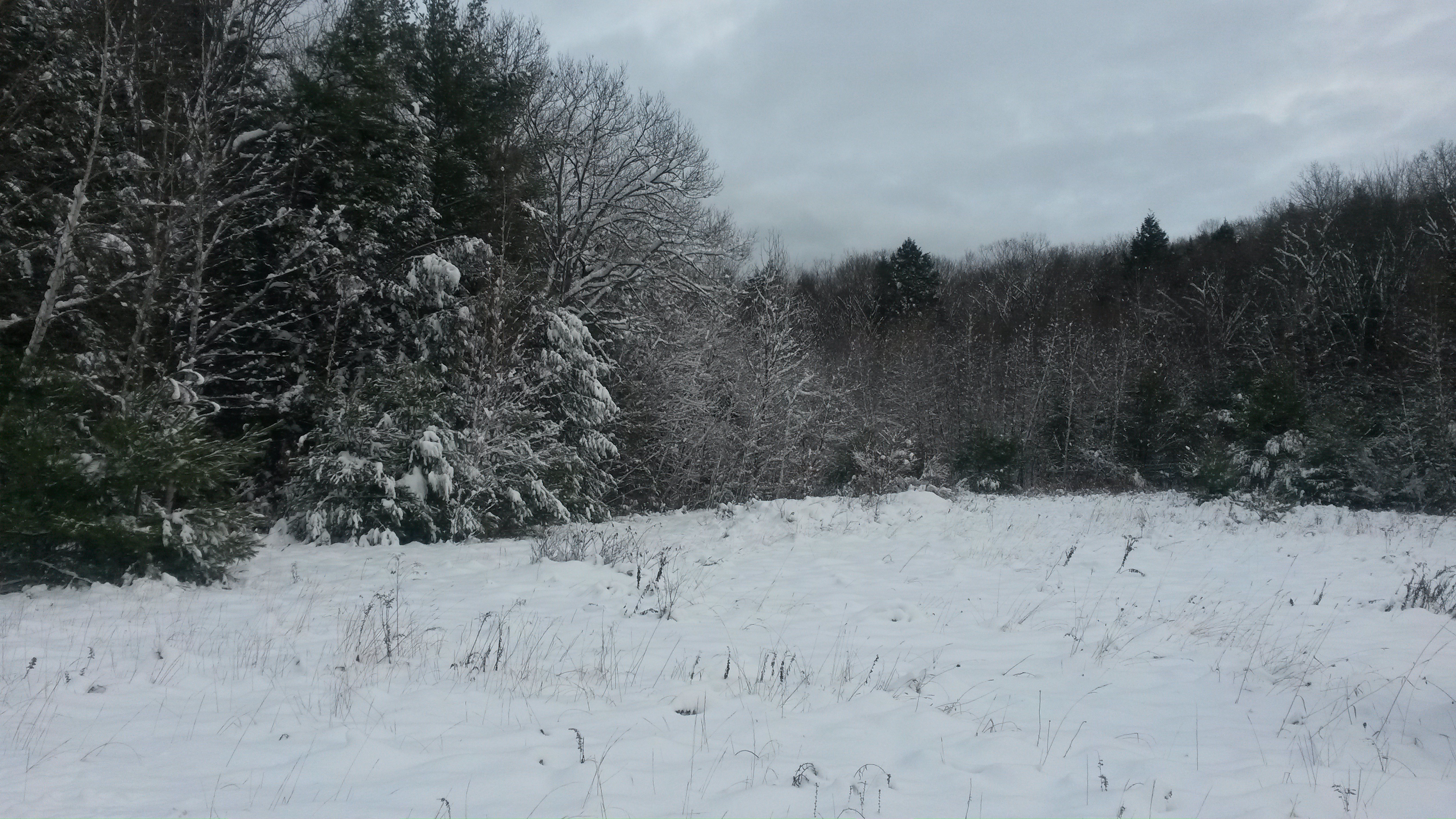
Snowy New Hampshire scenery, November 2014.Snow and glacier covered Denali in Alaska, 2013.
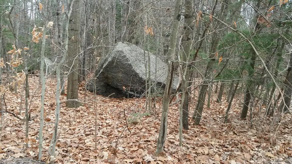
A glacial erratic in the woods near the Mervine Family Cabin in New Hampshire.
I spent the last two weeks of November visiting my family in New Hampshire. While I was in the US, I went on some long jogs and walks and took pictures of some glacial erratics, which can be found all around the Mervine Family Cabin in southern New Hampshire. This week’s “Monday Geology Picture” features a glacial erratic in the woods just down the road from the cabin. This large, angular rock was deposited during the retreat of the last ice age.
A U-shaped glacial valley on the Seward Peninsula outside of Nome, Alaska. Picture taken Summer 2013.
When glaciers erode landscapes, they often leave behind characteristic U-shaped valleys. This week’s Monday Geology Picture shows a U-shaped glacial valley on the Seward Peninsula in Alaska. This valley is located just outside of the gold mining town of Nome.
Does anyone else have good pictures of U-shaped valleys?