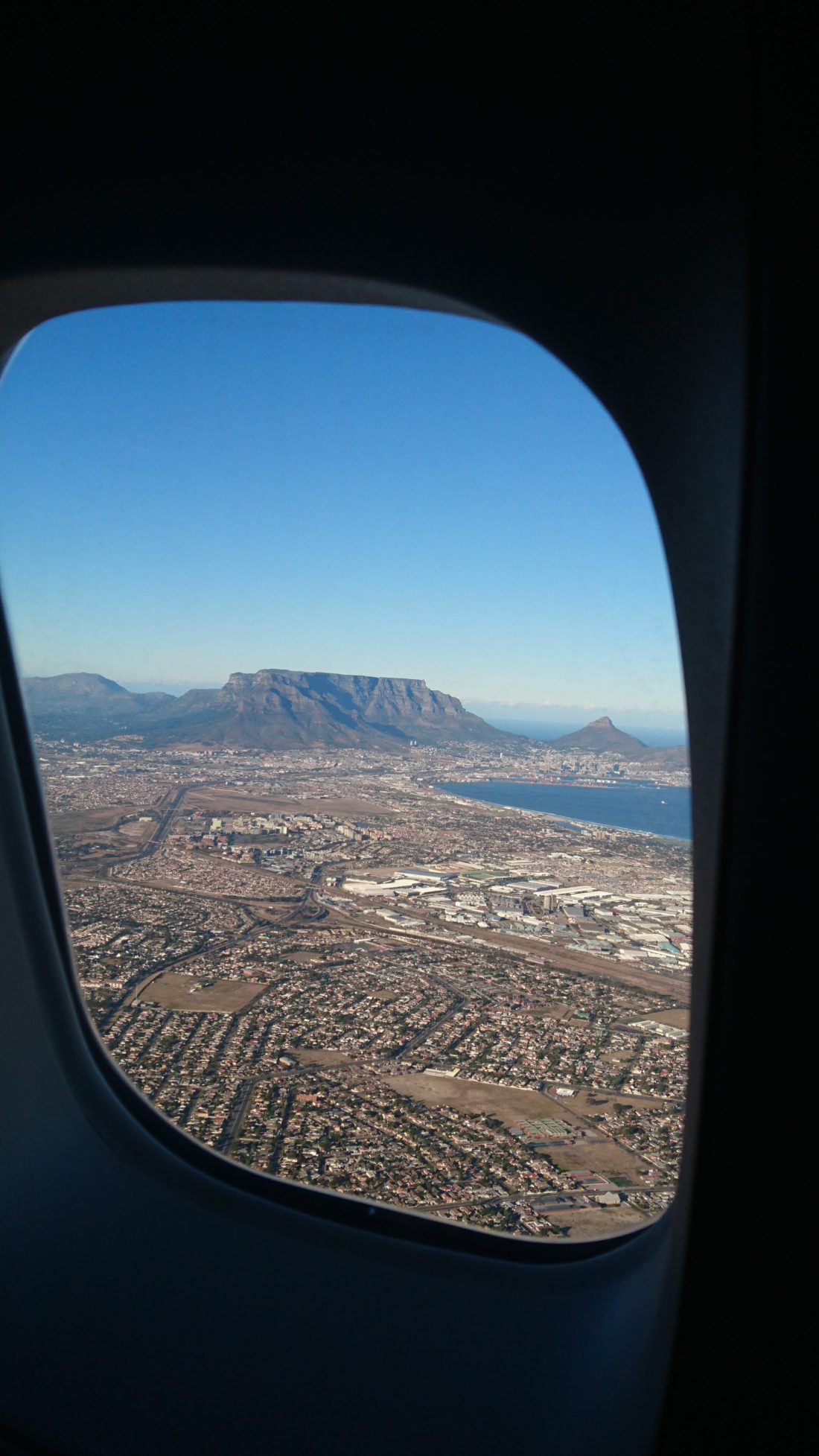
Yesterday morning I flew back to Cape Town after a business trip. I arrived a little after 7 am and was treated to a stunning view of Table Mountain and Lion’s Head as I flew in. I’m sharing a picture I snapped of that view as this week’s geology picture. Here’s a closer look as well:
A closer look at the mountain.
I am lucky to live in such a beautiful city! However, you can see that the city is looking somewhat brown and dry, due to the drought and water restrictions. No one is watering their gardens!
Lion’s Head. Photo taken from Sea Point Promenade, November 2017.
Happy New Year! I’m going to do my best to blog more regularly in 2018, starting with this first “Monday Geology Picture” post. This week I’m sharing a view of Lion’s Head (the distinctive mountain in the background of the picture), an inselberg here in Cape Town, South Africa, the city where I live. I took this picture a few weeks ago during a walk with my family along Sea Point Promenade. Cape Town is a fantastic city — you can see amazing geology even when you’re downtown!
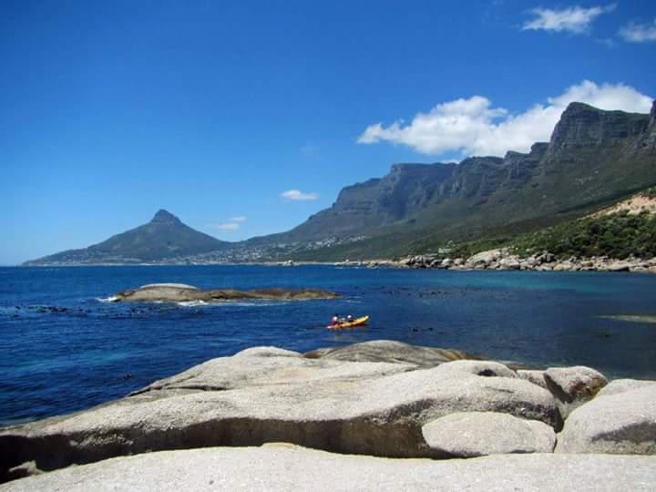
Some fantastic geologic scenery in Cape Town, South Africa: an inselberg (left) and the Twelve Apostles section of Table Mountain (right) in the background, a kayak in the middle, and some granitic rocks of the Cape Granite Suite in the foreground.
For this week’s picture, here’s a lovely view of an inselberg and the Twelve Apostles section of Table Mountain here in Cape Town, South Africa. Note the layers of sedimentary rocks of which the mountain is made. In the foreground, you can see some rocks of the Cape Granite Suite, which is about 550 million years old.
The Cape Fold Belt, viewed from the Stellenbosch winelands outside of Cape Town, South Africa.
For this week’s “Monday Geology Picture” here’s a view of the Cape Fold Belt with a vineyard in the foreground. I took this picture yesterday when I took a short walk with some friends through a vineyard located in the Stellenbosch winelands, just outside of my home city of Cape Town. You can see some impressive folding in those distant mountains!
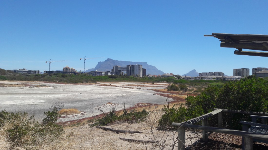
A salt pan on Intaka Island, with Table Mountain in the background.
For this week’s picture, here’s a view of a salt pan on Intaka Island, a small nature reserve in the Century City area of Cape Town. I often go to Intaka Island to paddle in a kayak on the canals surrounding the island. On Saturday morning I went for one of my usual paddles, and then in the afternoon I joined some friends for a nature walk on the island itself. During the walk, I snapped this picture of the salt pan on the island. The island nature reserve was founded to protect plants, bird, and other wildlife in the Century City area, which has been substantially developed since the late-1990s. In the background of this picture, you can see cranes where a block of apartments is being built on one of the last areas of open ground near the reserve. Table Mountain is also visible in profile in the background. Amidst all the development in busy, growing Cape Town, I’m glad that a few parcels of land, such as Intaka Island, have been set aside for conservation. I enjoy visiting Intaka a couple of times a week as an escape from the hustle and bustle, and all the concrete, of city life. I’ll have to share some more pictures of Intaka Island in a future post.
Several old maps of Africa on display. I love when maps are used as decoration! The skewness of these maps upsets my ODC tendencies, but in a way it also adds to the charm of the display!
Earlier this year I visited a local wine farm here in the Western Cape of South Africa, and there I saw a lovely display of some reproductions of some old maps of Africa. I’m not sure about the background of these maps, but I snapped a few pictures because I thought they were interesting. If you recognize any of the maps, please let me know in the comments.
Here are a couple of close-ups of the detailed map of the Cape Town area, where I live:
Cape Town area map.Cape Town area map – Close-up view.
If you look closely on the close-up view (click for a larger version), you can see that there are some useful descriptions on parts of the map. For example, there’s a description “Very Good Grounds” and then there’s a description “Grounds Not Fit for Tillage”. There are also some comments about the local mountain chains, with one being described as “Inaccessible Mountains” (I’ve corrected to modern spelling).
My husband and I live roughly in the “Grounds Not Fit for Tillage” part of the map, which probably explains why we struggle with our garden! The soil where we live is indeed very sandy and mostly comprised of quartz. Thus, it’s tough to grow anything other than local, native plants. So, we’ve planted a garden full of local succulents and are attempting this year to grow a few vegetables in a raised bed. We tried planting some flowers earlier this year, but only the ones in the pots (with special soil) seemed to survive!
I think that “Inaccessible Mountains” description may be fair, too. I’ve been on some tough hikes in that area!
I really enjoy old maps, and it’s great when they contain detailed information such as the Cape Town area map. I’d say that this map is still useful today!
A view of Cape Fold Belt mountains from the Hermanus Yacht Club, April 2016.
Over the weekend I participated in a kayak race that was held in the lovely little coastal town Hermanus, South Africa. The race was held on a lagoon with a beautiful background of mountains that are part of the Cape Fold Belt. You’ve seen pictures of this fold belt before here on Georneys. For example, here the belt is featured in one of Callan’s “Friday Fold” posts. However, these mountains are so pretty it’s worth sharing another picture here. Enjoy!
Since I live in Cape Town, South Africa, I often share pictures of beautiful Table Mountain. This week’s “Monday Geology Picture” shows another view of the mountain. I took this picture yesterday during a hike in the Tygerberg Nature Reserve. I’ll share some more pictures from the reserve in a separate post. For now, enjoy Table Mountain!
(Fake) boulders on display at the Cape Town International Airport.
Boulder’s Beach is a popular tourist attraction in the greater Cape Town area. At Cape Town International Airport, a small section of the airport has been decorated to resemble Boulder’s Beach, giant (fake) boulders and all! I enjoy walking past this decorated area every time I travel to the airport. Of course, even better is visiting Boulder’s Beach for real. For example, see some pictures from my visits here and here. I hope that the airport decoration inspires some tourists to go and visit Boulder’s Beach during their visits to beautiful Cape Town.
On Monday I shared one picture from a recent hike to Elephant’s Eye cave in Silvermine Nature Reserve here in the Cape Town region of South Africa. Today I’m sharing some more pictures from that hike, which took place last weekend.
I really enjoy hiking to Elephant’s Eye.The hike consists of a fairly easy 3 hour round trip route that takes you through some beautiful fynbos vegetation and past some lovely rock formations in Table Mountain Sandstone. The cave itself is a great destination that provides a nice place for lunch or a snack and, when the weather is clear, a fantastic view of the valley below. Generally, I hike to Elephant’s Eye two or three times a year. However, until last weekend I hadn’t hiked to Elephant’s Eye in well over a year. That’s because much of the Silvermine Nature Reserve was burned during a large forest fire last year. For most of last year, the hike to Elephant’s Eye was closed while the area recovered from the fire. The Elephant’s Eye hiking trial was only opened up again recently.
Without further ado, enjoy some pictures from the hike. Note that the weather was rainy and misty for our hike last weekend – however, I enjoyed hiking in the cooler weather. Also note how the vegetation has recovered significantly yet there are still signs of last year’s fire. For example, we saw burned logs and tree stumps amidst fresh green vegetation.
Elephant’s Eye Hike #2.Elephant’s Eye Hike #3. My husband Jackie and I competed for nerdiest t-shirt. My Star Wars t-shirt was pretty amazing, but I think that Jackie won the contest with his “Kitten Kong” t-shirt.Elephant’s Eye Hike #4.Elephant’s Eye Hike #5. A remnant of last year’s forest fire: a burned tree stump.Elephant’s Eye Hike #6. Note a few more charred tree stumps in this picture.Elephant’s Eye Hike #7. Trees and a cliff of Table Mountain Sandstone in the background.Elephant’s Eye Hike #8. Charred logs surrounded by green grass.Elephant’s Eye Hike #9. More charred logs and green grass.Elephant’s Eye Hike #10. The approach to the cave.Elephant’s Eye Hike #11. A misty view of the cave.Elephant’s Eye Hike #12. The cave itself.Elephant’s Eye Hike #13. The view from the cave entrance, shrouded in mist.Elephant’s Eye Hike #14. Another misty view from the cave.Elephant’s Eye Hike #15. We could see a little through the mist.Elephant’s Eye Hike #16. For a few minutes, the mist lifted and we had a lovely view of the valley below.Elephant’s Eye Hike #17. We saw some lovely pink March Lilies – they’re a little early this year!Elephant’s Eye Hike #18. On our way back to the parking lot, we took a small detour and walked past a beautiful lake. Note more charred tree remains here.Elephant’s Eye Hike #19.Elephant’s Eye Hike #20. Water lilies viewed from the bridge.Elephant’s Eye Hike #21. Another view of the water lilies.Elephant’s Eye Hike #22. Yet another view of the water lilies.Elephant’s Eye Hike #23. One last view of the lake as we headed back to the parking lot.
That’s all for now. Stay tuned for more pictures of hikes in the Cape Town area. In August I’ll be backpacking the Fish River Canyon in Namibia with friends, so I’ll be going on a number of training hikes this year. My goal is to hike 2 or 3 times per month. I’m fortunate to live in a part of the world with such lovely hiking trails!