Fox Forest in Pictures

Fox Forest #1. Trees and glacial erratic boulders.

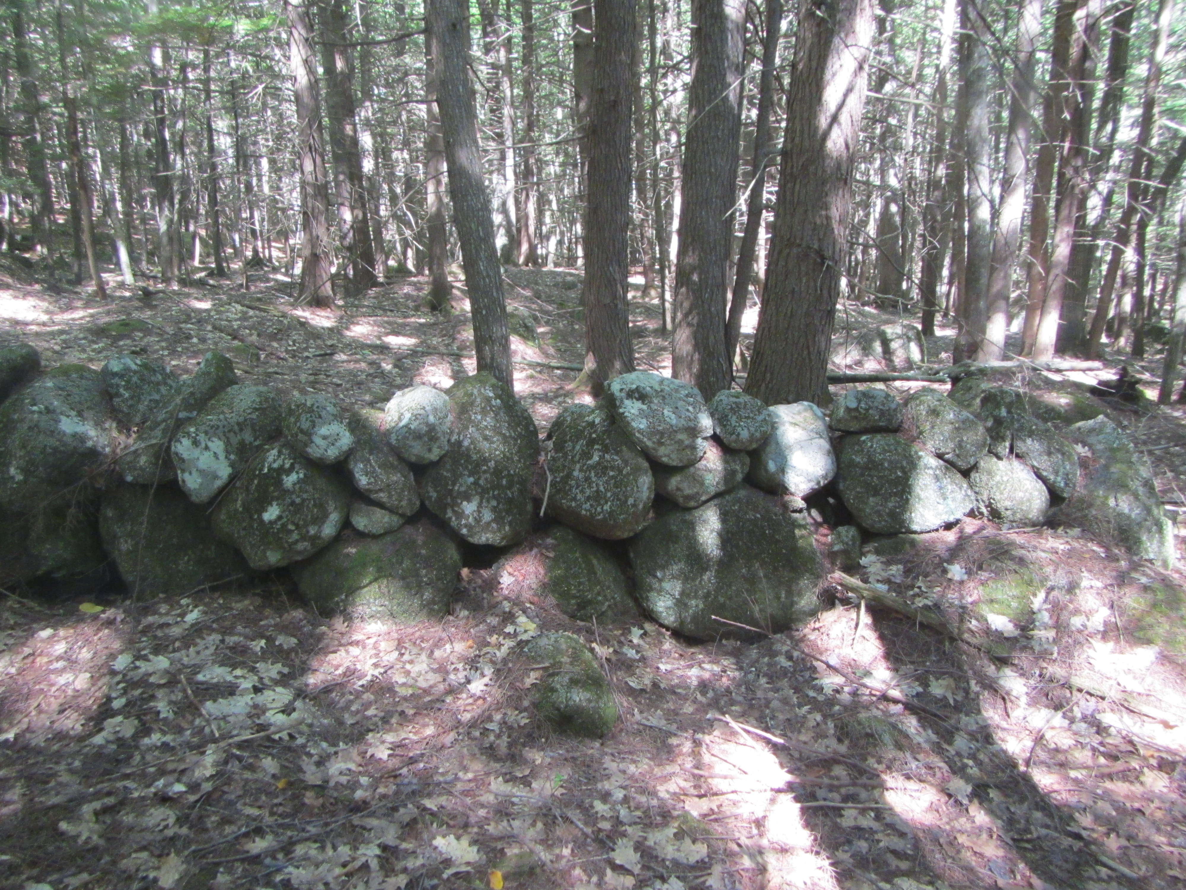
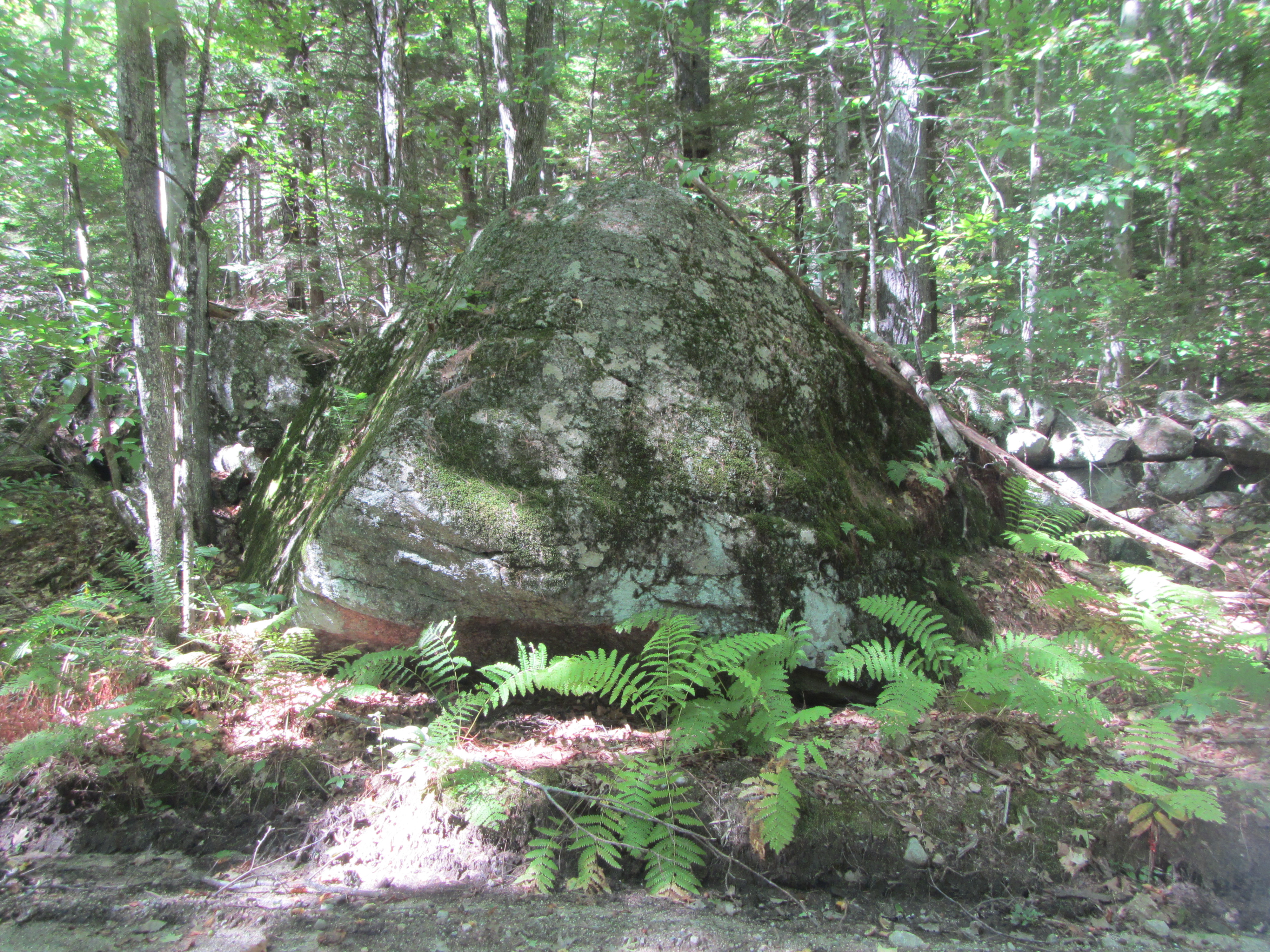
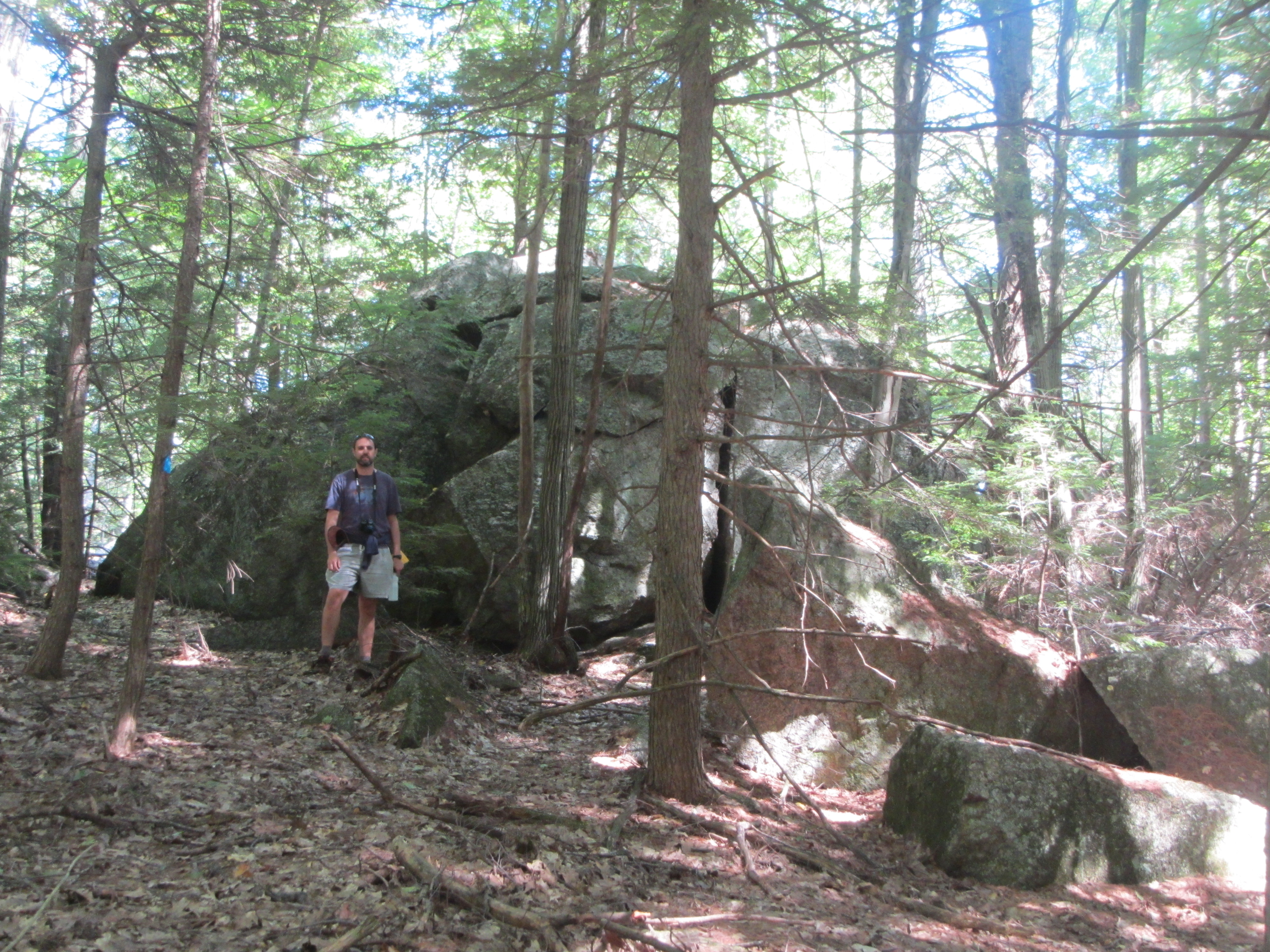
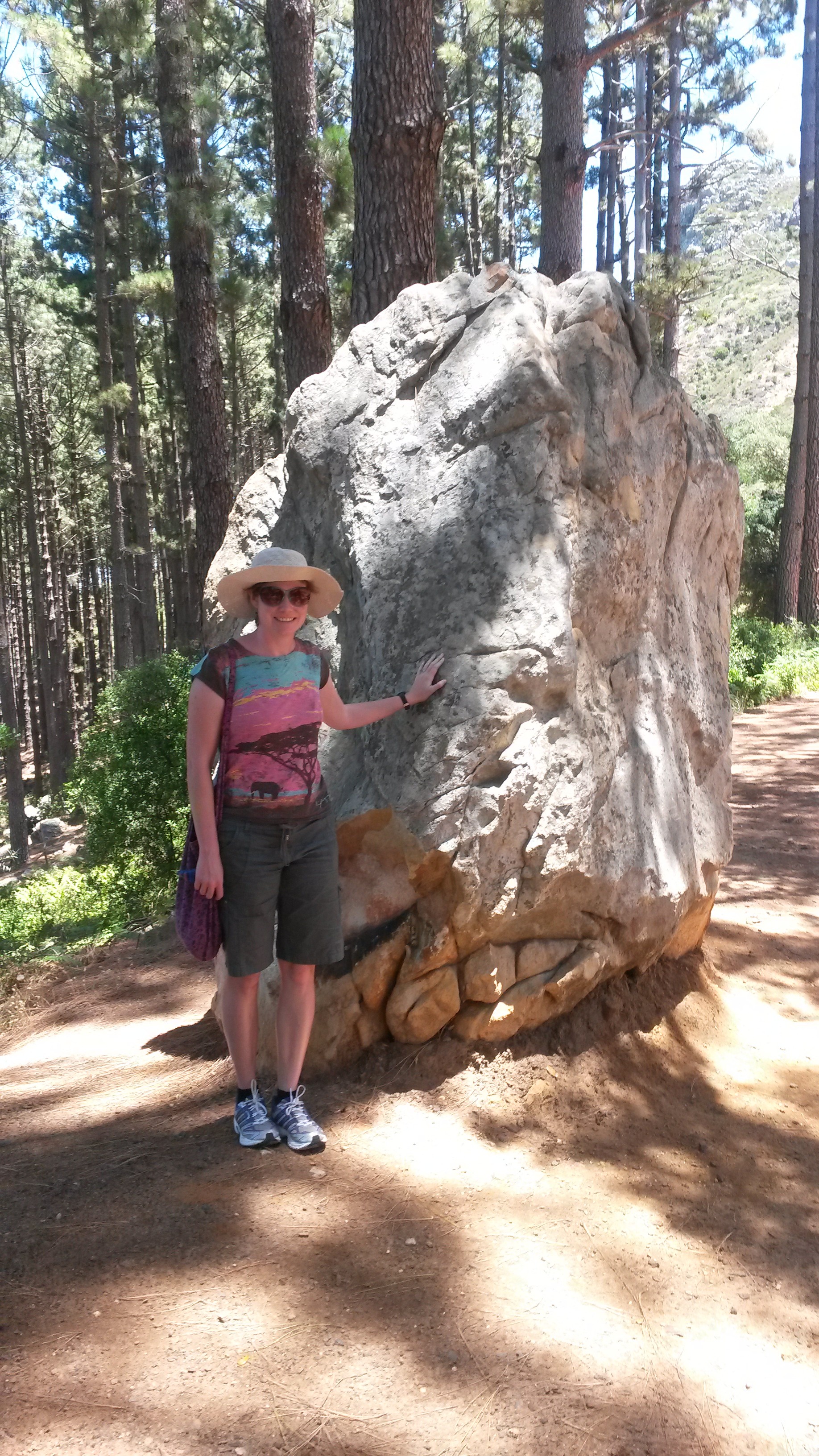
For this week’s Monday Geology Picture I shared a picture of a stone wall incorporating a large glacial erratic. I took this picture recently in Fox Forest in southern New Hampshire. Yesterday, my husband and I went on a lovely hike in the forest. We saw quite a few glacial erratics… parts of the forest are piled high with them! We also saw many stone walls incorporating glacially dropped stones. Most of the forest is relatively young and grew up over the past hundred years or a little less on top of former farmland. You thus see old stone walls, the outlines of former fields, throughout the forest. You can also see old building foundations and even an old cemetery. A few parts of the forest are “virgin” and contain older trees, including some that are hundreds of years old. All in all, I recommend a walk in the forest. You can see some glacial geology… and learn about the trees and other vegetation, too!

I thought I’d share a few more pictures of our hike yesterday. If you want to read more about glacial erratics and stone walls in New England, I highly recommend this Earth Magazine article. Thanks to AGI for recommending the article to me on Twitter!

Without further ado, here are some more pictures from lovely Fox Forest:

Fox Forest #2. More glacial erratic boulders amidst the trees.
Fox Forest #2. More glacial erratic boulders and trees.
Fox Forest #3. A glacial erratic boulder, with geologist on top for scale.
Fox Forest #4. Erratics, erratics everywhere!
Fox Forest #5. Moss-covered erratics and some ferns.
Fox Forest #6. A stone wall made out of glacial erratics.
Fox Forest #7. A closer view of the stone wall.
Fox Forest #8. A long stone wall running through the forest.
Fox Forest #9. A stone wall incorporating a very large erratic boulder.
Fox Forest #10. An old cemetery in the middle of the forest.
Fox Forest #11. Cemetery headstones.
Fox Forest #13. A fallen headstone, in the process of being restored.
Fox Forest #12. A fallen headstone, in the process of being restored.
Fox Forest #14. Another large erratic boulder, with another geologist for scale.
Fox Forest #13. Another large erratic boulder, with another geologist for scale.
Fox Forest #15. Another stone wall.
Fox Forest #14. Another stone wall.
Fox Forest #16. Fading afternoon light in the forest, near the entrance to the hiking trail.
Fox Forest #15. Fading afternoon light in the forest, near the entrance to the hiking trail.

Kolmanskop in Pictures

Kolmanskop #1. Sitting on some sand in one of the abandoned houses.

Last month I spent some time in Namibia for work. During one of my days off, I was able to spend some time visiting Kolmanskop. Located in the Namib Desert a few miles outside of the seaside town of Lüderitz, Kolmanskop is a “Ghost Town” that is the remains of a former diamond mining town. Kolmanskop was founded shortly after diamonds were discovered in the region in 1908 and was abandoned to the elements in 1954, after the diamond supply was depleted. Over the last sixty years, Kolmanskop has been decaying in the desert, battered by the wind and swept over with sand. Today, many of the buildings are half-filled with sand. The discarded possessions of the town’s former inhabitants are either slowly disintegrating in the open air or are precariously protected by glass display cases. The town of Kolmanskop is managed as a tourist attraction by the diamond mining company Namdeb. Tourists can pay a fee to visit the town during certain hours. At their own risk, tourists can wander through the abandoned buildings.

Visiting Kolmanskop was a fascinating and surreal experience. As I explored the ghostly town, I felt keenly aware of the insignificance and ephemeral nature of my life. I wondered if, one day years from now, a young woman will wander through the decaying remains of my home… or perhaps come across a former possession of mine– maybe a book, with my name written on the front cover, dusty in the corner of an antique shop– and wonder, just for a moment, about the object’s former owner.  Wandering through Kolmanskop, I found myself thinking about one of my favorite Carl Sagan quotations, from the book Pale Blue Dot:

Look again at that dot. That’s here. That’s home. That’s us. On it everyone you love, everyone you know, everyone you ever heard of, every human being who ever was, lived out their lives. The aggregate of our joy and suffering, thousands of confident religions, ideologies, and economic doctrines, every hunter and forager, every hero and coward, every creator and destroyer of civilization, every king and peasant, every young couple in love, every mother and father, hopeful child, inventor and explorer, every teacher of morals, every corrupt politician, every “superstar,” every “supreme leader,” every saint and sinner in the history of our species lived there- on a mote of dust suspended in a sunbeam.

The Earth is a very small stage in a vast cosmic arena. Think of the endless cruelties visited by the inhabitants of one corner of this pixel on the scarcely distinguishable inhabitants of some other corner, how frequent their misunderstandings, how eager they are to kill one another, how fervent their hatreds. Think of the rivers of blood spilled by all those generals and emperors so that, in glory and triumph, they could become the momentary masters of a fraction of a dot.

Our posturings, our imagined self-importance, the delusion that we have some privileged position in the Universe, are challenged by this point of pale light. Our planet is a lonely speck in the great enveloping cosmic dark. In our obscurity, in all this vastness, there is no hint that help will come from elsewhere to save us from ourselves.

The Earth is the only world known so far to harbor life. There is nowhere else, at least in the near future, to which our species could migrate. Visit, yes. Settle, not yet. Like it or not, for the moment the Earth is where we make our stand.

It has been said that astronomy is a humbling and character-building experience. There is perhaps no better demonstration of the folly of human conceits than this distant image of our tiny world. To me, it underscores our responsibility to deal more kindly with one another, and to preserve and cherish the pale blue dot, the only home we’ve ever known.

With that quotation in mind, enjoy my pictures from Kolmanskop:

Kolmanskop #2.
Kolmanskop #2.
Kolmanskop #3.
Kolmanskop #3.
Kolmanskop #4.
Kolmanskop #4.
Kolmanskop #5.
Kolmanskop #5.
Kolmanskop #6.
Kolmanskop #6.
Kolmanskop #7.
Kolmanskop #7.
Kolmanskop #8.
Kolmanskop #8.
Kolmanskop #9.
Kolmanskop #9.
Kolmanskop #10.
Kolmanskop #10.
Kolmanskop #11.
Kolmanskop #11.
Kolmanskop #12.
Kolmanskop #12.
Kolmanskop #14.
Kolmanskop #13.
Kolmanskop #14.
Kolmanskop #14.
Kolmanskop #15.
Kolmanskop #15.
Kolmanskop #16.
Kolmanskop #16.
Kolmanskop #17.
Kolmanskop #17.
Kolmanskop #18.
Kolmanskop #18.
Kolmanskop #19.
Kolmanskop #19.
Kolmanskop #20.
Kolmanskop #20.
Kolmanskop #21.
Kolmanskop #21.
Kolmanskop #22.
Kolmanskop #22.
Kolmanskop #23.
Kolmanskop #23.
Kolmanskop #24.
Kolmanskop #24.
Kolmanskop #25.
Kolmanskop #25.
Kolmanskop #26.
Kolmanskop #26.
Kolmanskop #27.
Kolmanskop #27.
Kolmanskop #28.
Kolmanskop #28.
Kolmanskop #29.
Kolmanskop #29.
Kolmanskop #30.
Kolmanskop #30.
Kolmanskop #31.
Kolmanskop #31.
Kolmanskop #32.
Kolmanskop #32.
Kolmanskop #33.
Kolmanskop #33.
Kolmanskop #34.
Kolmanskop #34.
Kolmanskop #35.
Kolmanskop #35.
Kolmanskop #36.
Kolmanskop #36.
Kolmanskop #37.
Kolmanskop #37.
Kolmanskop #38.
Kolmanskop #38.
Kolmanskop #39.
Kolmanskop #39.
Kolmanskop #40.
Kolmanskop #40.
Kolmanskop #41.
Kolmanskop #41.
Kolmanskop #42.
Kolmanskop #42.
Kolmanskop #43.
Kolmanskop #43.
Kolmanskop #44.
Kolmanskop #44.
Kolmanskop #45.
Kolmanskop #45.
Kolmanskop #46.
Kolmanskop #46.
Kolmanskop #47.
Kolmanskop #47.
Kolmanskop #48.
Kolmanskop #48.
Kolmanskop #49.
Kolmanskop #49.
Kolmanskop #50.
Kolmanskop #50.

Constantia Nek Walk in Pictures

Below are a few more pictures from a recent walk along the Constantia Nek contour path here in Cape Town. I featured a picture from this same walk in this week’s “Monday Geology Picture” post.

A view of some of Cape Town's winelands. Picture taken December 2013.
A view of some of Cape Town’s winelands. Picture taken December 2013.
Yours truly posing with a boulder of Table Mountain Group quartzite. Picture taken December 2013.
A pretty red flower along the path. Picture taken December 2013.

I feel very fortunate to live in a city that has many beautiful walks and hikes. I’ll do my best to explore some more of them– and re-visit some old favorites– in 2014.

LASI V Field Trip in Pictures

I’ve been meaning for months to post some pictures from the LASI V Field Trip that I participated in just over a year ago in November 2012. However, despite my best intentions, I never ended up posting some field trip pictures. This is primarily because I lost all of my own LASI V field trip pictures when my laptop and a hard drive were stolen from my apartment back in April. I was quite upset about this and have now diligently backed up all of my computer data online as well as on multiple hard drives. Fortunately, my fellow field trip participants Ben Manton and Stephanie Scheiber were kind enough to send me some of their pictures to share with you here on Georneys.

In the interest of wrapping up a few things here on Georneys before the end of the year, I thought I’d (finally!) share some pictures from the LASI V field trip. You can find my previous posts about LASI V here. A good introductory post about LASI V is here. In brief, the LASI V workshop was a gathering of geologists from around the world to discuss the geology of subvolcanic systems such as sills, dykes, and laccoliths. The field trip went to several places in South Africa’s Karoo region to look at large dolerite sills, hydrothermal vent complexes, and other subvolcanic features which have intruded into various sedimentary units.

Without futher ado, here are some pictures from the LASI V field trip:

Sills on top of a hill, with termite mounds in the foreground. Picture courtesy of Ben Maton.
Dolerite sills on top of a hill, with termite mounds in the foreground. Picture courtesy of Ben Manton.
On top of a sill in the Golden Valley region. Picture courtesy of Ben Maton.
The view from the top of a dolerite sill in the Golden Valley region. Picture courtesy of Ben Manton.
Sills in Golden Valley. Picture courtesy of Ben Maton.
Impressive dolerite sills in Golden Valley. Picture courtesy of Ben Manton.
A beautiful view in the Karoo. Picture courtesy of Ben Maton.
A beautiful view in the Karoo. Picture courtesy of Ben Manton.
Whitkop feature. Picture courtesy of Ben Maton.
Whitkop, a hydrothermal vent feature.  Whitkop means “white head” or “white little hill”. Picture courtesy of Ben Manton.
Fluid flow features on Whitkop. Picture courtesy of Ben Maton.
Fluid flow features on Whitkop. Picture courtesy of Ben Manton.
Circular pipe structures in the Whitkop hydrothermal vent. Picture courtesy of Ben Maton.
Circular pipe structures on Whitkop. Picture courtesy of Ben Manton.
Group hiking up a steep slope. Picture courtesy of Ben Maton.
Checking out some geology (spherical weathering, among other things) on a steep slope. Picture courtesy of Ben Manton.
Another beautiful view in the Karoo. Picture courtesy of Ben Maton.
Another beautiful view in the Karoo. Picture courtesy of Ben Manton.
Impressive spheroidal weathering of a dolerite sill. Picture courtesy of Stephanie Scheiber.
More spheroidal weathering. Picture courtesy of Stephanie Scheiber.
Dwyka tillite, one of my favorite rocks! Picture courtesy of Stephanie Scheiber.
Another view of Dwyka tillite. Picture courtesy of Stephanie Scheiber.
A hydrothermal vent complex... with cows. There are many. many cows and sheep in the Karoo! Picture courtesy of Stephanie Scheiber.
A hydrothermal vent complex… with cows. There are many. many cows and sheep in the Karoo! Picture courtesy of Stephanie Scheiber.
A windmill in the foreground, a dolerite sill in the background. Picture courtesy of Stephanie Scheiber.
A windmill and termite mounds in the foreground, dolerite sills in the background. Picture courtesy of Stephanie Scheiber.
Geologists amongst the dolerite sills. Picture courtesy of Stephanie Scheiber.

Monday Geology Picture: A Lovely, Geological View in Stellenbosch

A lovely view on a lovely wine farm on a lovely day.

Yesterday my husband and I joined our good friends Patrick and Nia for lunch at the renowned Terroir Restaurant located on the Kleine Zalze wine farm in beautiful Stellenbosch, South Africa. The food was delicious, and we also enjoyed stunning views of the Cape Fold Belt, such as the view in this week’s “Monday Geology Picture.”

Speaking of Patrick and Nia, they’ve kindly sent through some pictures from their recent vacation in Greece. I’m looking forward to sharing some of those pictures with you here as part of future “Monday Geology Picture” posts. You may remember that last year I shared some geological pictures from Patrick and Nia’s 2012 vacation to the Seychelles, where one can see, among other things, Gondwana granites.

The Last Train to Nowhere in Pictures

The Last Train to Nowhere #1.

I thought I would continue with a few more posts from Alaska.

My husband and I were in Nome, Alaska during July – September 2012. On sunny (and some stormy) days we were generally working. However, on days with poor weather and high seas or winds, we often had some time to explore Nome and the surrounds. One day, we drove up the road to visit The Last Train to Nowhere, a set of three 1880s era steam locomotives that were brought to the Solomon River area outside of Nome in the early 1900s. These locomotives and a few other scattered pieces of metal are all that remains of a failed attempt to build a railway along the Solomon River to a place called Council City, where gold had been discovered. The railway ran for two summers under terrible conditions “unfit for either man or beast” (according to a sign near the trains) and then filed for bankruptcy in 1907. In 1913 a large storm destroyed a railway bridge and washed away most of the tracks, stranding the locomotives where they sit today. Since the train doesn’t go anywhere today, locals have dubbed the stranded locomotives, “The Last Train to Nowhere.”

To reach the train, we drove along a dirt road in a beat-up pick-up truck on a cold and windy August day. Along the way, we also visited a place called “The Safety Roadhouse”, which serves as the last checkpoint of the Iditarod sled dog race, and we explored some old gold dredges.

The Last Train to Nowhere #2.
The Last Train to Nowhere #3.
An informational sign about the train.
Another informational sign about the train.
Posing with the train. Yes, I am wearing two jackets and a hat in August!
Last Train to Nowhere #4.
Last Train to Nowhere #5.
Last Train to Nowhere #6, with husband for scale.
Another abandoned item near the train. This looks like a ship's hull, but we think it used to be part of a water tower.
Waving through a window.
Continuing up the road past the train, we found some weathered, old buildings.
An abandoned gold dredge.
A closer view of the dredge.
Waterlogged dredge buckets.
Another view of the dredge buckets.
Remnants of winter snow along the road.
An Alaskan flag, flapping in the wind.
The Safety Roadhouse, located on Safety Sound.
The walls inside the roadhouse are covered in dollars and other bills.
The ceiling is covered, too...
We added a South Africa R10 note... next to one left previously by some colleagues of ours.

I still have a few more posts about Alaska coming in the future… hope you’re enjoying these!

A Drive to Salmon Lake, Alaska in Pictures

Salmon Lake #1. The sign for the Salmon Lake Campground.

On one of our last days in Nome, Alaska, my husband and I had the opportunity to drive up the road to a little place called Salmon Lake. The U.S. Bureau of Land Management operates a summer campground on the shore of Salmon Lake. We drove up to Salmon Lake to check out the beautiful scenery (especially the gorgeous, snow-capped Kigluaik Mountains) and also to take a look at some regional geology. We were fortunate enough to have a beautiful, sunny September day for our drive. I thought I would share some pictures that we took along the drive. Enjoy!

First, here’s a map showing the location of Nome:

And here’s a map showing the route from Nome (A) to Salmon Lake (B):

On our drive, we actually continued past Salmon Lake for a few miles before turning around and heading back to Nome.

Second, here’s an informational blurb on Salmon Lake from the BLM website:

The Nome Field Station maintains Salmon Lake Campground, 40 miles north of Nome on the Nome-Kougarok Road. The campground offers 6 campsites with fire pits and picnic tables, a natural boat launch at Salmon Lake, and an outhouse. The campground opens in late June after the Nome-Kougarok Road is free of snow and remains open until mid October, depending on snow and road conditions. The Salmon Lake area offers outstanding recreational opportunities. It’s the spawning grounds for the northernmost run of sockeye salmon in the United States.

And now for the pictures:

Salmon Lake #2. Fall colors, arctic tundra style.
Salmon Lake #3.
Salmon Lake #4.
Salmon Lake #5. Those are the Kigluiak Mountains in the distance.
Salmon Lake #6.
Salmon Lake #7. The sign reads "No Road Maintenance Beyond This Point."
Salmon Lake #8.
Salmon Lake #9.
Salmon Lake #10.
Salmon Lake #11.
Salmon Lake #12. My handsome co-driver.
Salmon Lake #13.
Salmon Lake #14.
Salmon Lake #15.
Salmon Lake #16.
Salmon Lake #17.
Salmon Lake #18.
Salmon Lake #19.
Salmon Lake #20.
Salmon Lake #21.
Salmon Lake #22.
Salmon Lake #23.
Salmon Lake #24.
Salmon Lake #25.
Salmon Lake #26.
Salmon Lake #27.
Salmon Lake #28.
Salmon Lake #29.
Salmon Lake #30.
Salmon Lake #31.
Salmon Lake #32.

Nome, Alaska in Pictures: Part III

Homemade gold dredges in the Nome Harbor.

Today I thought I’d share a few more pictures from the two months that my husband Jackie and I recently spent working in Nome, Alaska. You can find more pictures of Nome in Part I and Part II. Enjoy!

A little dredge named the "Golden Wave"-- a converted pontoon boat.
Checking out the famous (from the TV show "Bering Sea Gold") dredge named "The Christine Rose."
Gas prices in Nome!
Food prices in Nome are rather high. A box of granola bars is $6.29 and a box of oatmeal is $7.19. Food is so expensive because nearly all the food is brought in by airplane or boat since no roads lead to Nome from bigger towns or cities.
Liquids are very expensive in Nome. A 12-pack of soda costs $15.99.
I really hope this isn't Nome's only vet... or that it's bigger on the inside.
Jackie trying on a polar bear fur hat at "The Russian Shop," as we call it.
The really neat painted wooden camel that I acquired from "The Russian Shop." I have a collection of camel figurines. Feel free to donate any interesting camels to my collection! 🙂
The Nugget Inn.
Breakers Bar and the Anchor Tavern.
Nome City Hall.
One of Nome's churches.
An abandoned building on main street. Looks as if there may have been a fire?
One of Nome's restaurants.

Nome, Alaska in Pictures: Part II


My husband Jackie and I in front of Nome's gigantic gold pan on the town square.

Here are some more pictures from the two months which my husband and I recently spent working in Nome, Alaska. Today I thought I’d share some pictures of the town square, which is called Anvil City Square. The town square is adorned with several items which honor the town’s gold mining history (a giant gold pan, gold dredge buckets, statues of the people who first discovered the gold, and information signs) and the famous Iditarod sled dog race (statues and information signs), which ends in Nome. You can find more pictures of Nome in Part I here. Enjoy!

Another view of the town square. The town square is edged with metal gold dredge buckets which have been turned into flower pots.
Another view of the town square showing the giant gold pan and the statues of "The Three Lucky Swedes."
Making friends with one of the lucky Swedes... I hear he's rich!
Jackie and I checking out some of the Three Lucky Swedes' gold.
A sign about the Three Lucky Swedes and their gold discovery in Nome. There are many such informational signs around Nome. I'm not sure who was responsible for putting them up, but they are much appreciated! Click to enlarge the picture if you want to try to read the sign.
A closer view of the pictures of the Three Lucky Swedes on the information sign.
They say that even the flower pots in Nome contain gold... perhaps that's because all the flower pots are old gold dredge buckets!

For those who don’t know, this is what a gold dredge looks like:

An abandoned gold dredge about a two hour drive outside of Nome. Note the buckets on the right side of the dredge.
A closer view of some dredge buckets on the dredge in the above picture.

I’ll be writing more about some of Nome’s gold dredges in a later post, so stay tuned!

Posing with some Iditarod sled dogs.
And Jackie and I thought we were clever and had thought up that slogan...

That’s all for now– hope you enjoyed!

Nome, Alaska in Pictures: Part I

Rust and paint on a gas tank in Nome.

I haven’t done an “…in Pictures” post for awhile, and I have many, many photographs from Nome, Alaska to share with you. I just spent 2 months living and working in Nome, which is an unusual town filled with gold miners in the summer and sled dog racers in the winter. About 3,000 people call Nome home year round. No roads lead to Nome, so everything (people, cars, mining equipment, etc.) is brought in either by airplane or by boat. Because of this, nothing ever leaves Nome. Well, people do, but things (aside from gold, of course) rarely do. The yards of many of the houses in Nome are filled with years of discarded cars, equipment, tools, and so on. Various fields at the edges of town are piled with mounds of junk. I guess it’s just too expensive to remove worn-out items. At first, I found Nome overwhelming and a little bit scary. After a few weeks, however, Nome– piles of rusted junk and all– began to grow on me. While I’m happy to be back at my home base in Cape Town now, I can truly say that I enjoyed my two months in Nome.

Today I’m going to share some pictures from Nome. I took all of the pictures in this post during a walk on a rare sunny (well, overcast… but the sun poked through the clouds sometimes) day back in August. In future posts I’ll share some additional pictures from Nome. Enjoy!

Nome #1. Those are little gold dredge boats on the horizon.
Nome #2. Again, those are little gold dredge boats on the horizon.
Nome #3. Some houses and a wood stockpile.
Nome #4. More houses.
Nome #5. Seagulls and a sign.
Nome #6. Another view of some little gold dredge boats.
Nome #7. A closer view of some gold dredge boats.
Nome #8. The nicest house in Nome?
Nome #9. A bush plane flying over some houses.
Nome #10. A closer view of the bush plane.
Nome #11. Interestingly, many of the locals are Green Bay Packers fans.
Nome #12. Bible & Bookstore.
Nome #13. Another house.
Nome #14. An interestingly shaped house.
Nome #15. A sidewalk mermaid.
Nome #16. Little gold dredge boats everywhere.
Nome #17. Another close-up view of some gold dredge boats.
Nome #18. Some of the little gold dredge boats seem to barely float!
Nome #19. A little gold dredge boat with another little boat in tow.
Nome #20. An ominous sky over the little gold dredge boats.
Nome #21. Looking back towards town from the beach.
Nome #22. The Nome Trading Company.
Nome #23. Well, I bet you won't see this creative home decoration in Martha Stewart's "Living."
Nome #24. A crazy caravan and an American flag.
Nome #25. Abandoned mining equipment from one of Nome's previous gold rushes.
Nome #26. Gears and tundra flowers.
Nome #28. An old cement mixer truck.
Nome #29. More old gold mining equipment.
Nome #30. Gold dredging equipment, old and new.
Nome #31. Addressed to Nome.
Nome #32. An old Ford.
Nome #33. A painted gas tank.
Nome #34. Truck trailers.
Nome #35. Big Jim's Auto Repair.
Nome #37. Junk everywhere!
Nome #37. Beaver digger.
Nome #38. Containers.
Nome #39. Subway... and Nome's movie theater!
Nome #40. Nome's best restaurant (in my opinion, anyway): The Bering Sea!

Hope you enjoyed these pictures from Nome. I’ll share more soon.