Monday Geology Picture: An Early Map of Arabia

A Map of Arabia by Abraham Ortelli, circa 1570. Map print hanging in the Dubai Museum, September 2013.
Map of Arabia by Abraham Ortelius, circa 1570. Map print hanging in the Dubai Museum, September 2013.

Back in September 2013 I visited Dubai for one day during a layover when I was flying from Alaska back to South Africa. I was fortunate enough to be able to sleep on the flight from New York to Dubai, so when I arrived in Dubai I took a quick shower at the hotel then headed out to explore for a few hours. I spent some time at the Dubai Museum. The museum is located in a fort that is the oldest building in Dubai and has several interesting exhibits. I’ll blog a little more about my visit to the museum later this week.

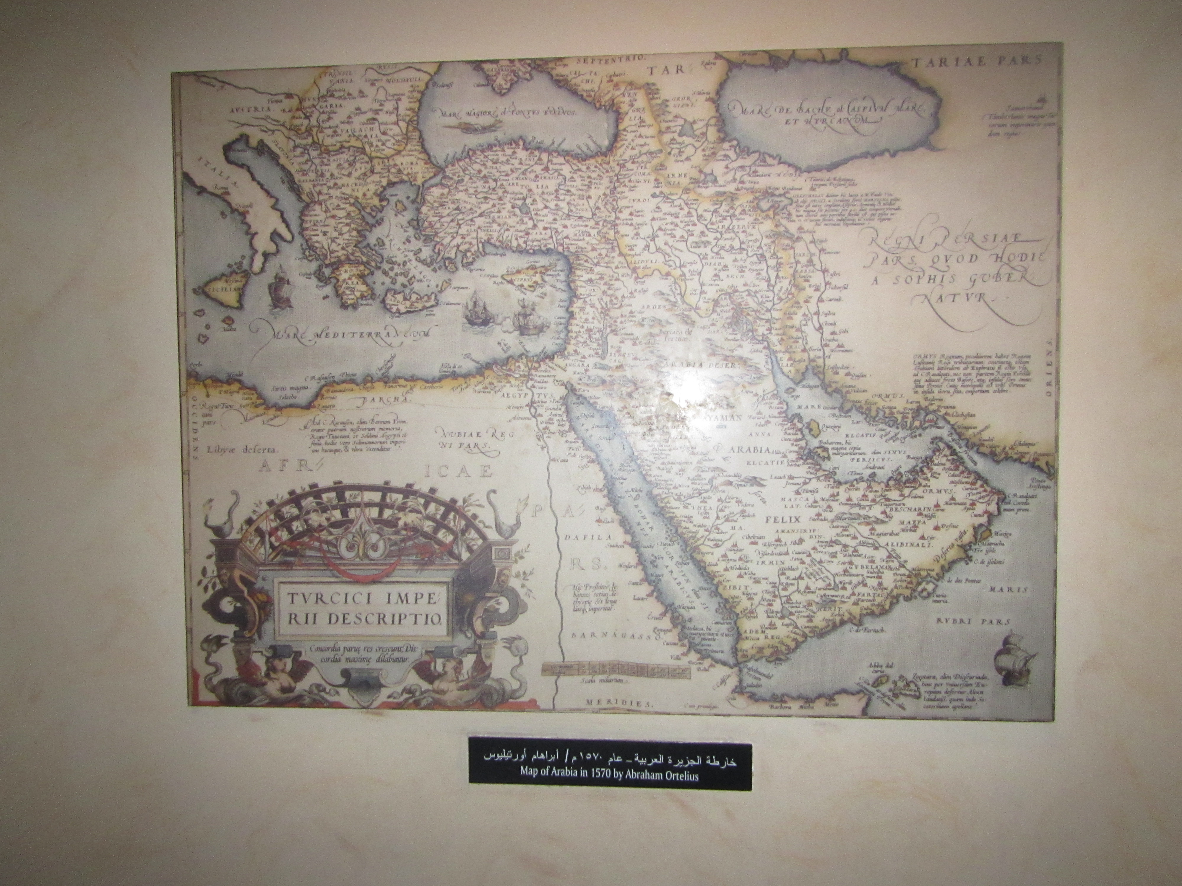
For now, I want to share this picture of an interesting map that was displayed in a little nook in one part of the museum. As I was walking through the museum, the map caught my eye, so I took a picture of it. The map is titled “Map of Arabia in 1570 by Abraham Ortelius”. I was intrigued by the map as I thought that 1570 was quite early for such a detailed map to have been produced for the region. When I did some googling after the museum visit, I discovered that the map comes from a book known as the Theatrum Orbis Terrarum (Theatre of the World), which is considered to be the world’s first modern atlas. This atlas was compiled by Abraham Ortelius, a Flemish cartographer and geographer. I’ll have to do some reading on Ortelius– he sounds like he was a very interesting person. According to Wikipedia, he was apparently one of the first people (the first person?) to propose the theory of continental drift… long before Alfred Wegener!

Monday Geology Picture: Shipwreck on Noordhoek Beach, South Africa

The S. S. Kakapo shipwreck on Noordhoek Beach.

Sometimes, manmade objects become part of the geological landscape. For example, on Noordhoek (which means “North Corner”, in Dutch and Afrikaans) Beach near Cape Town, South Africa, there is a shipwreck at one end of the beach. Two rusted boilers and a ring of metal ribs– sticking up out of the sand like a picket fence– are all that remain of the S. S. Kakapo, a New Zealand steamship that became stranded on the beach in 1900. You can read all about the wreck of the S. S. Kakapo here. In this Anthropocene time discarded manmade objects no doubt have a big impact on the Earth and its various processes. While the remains of the S. S. Kakapo likely have a fairly small impact on the environment, the skeletal shipwreck nonetheless reminds me of the traces we humans leave behind. 114 years after the shipwreck, the ghostly metal outline of the S. S. Kakapo remains.

Monday Geology Picture(s): Oudekraal Beach, South Africa

A stunning location for a birthday.
A stunning location for a birthday party. In this picture my friend Kaylee and I check out some of the giant granitoid boulders by kayak.

Yesterday was my 30th birthday. Amongst other wonderful things, my husband Jackie organized a surprise birthday party for me at Oudekraal, a beautiful beach (and national park) here in Cape Town. Bordered on one side by gigantic boulders and turquoise-blue waters and flanked on the other side by tall, jagged, gray-green mountains, Oudekraal is a stunning location. Jackie rented a kayak, brought plenty of delicious picnic food, and invited many good friends for my party. The weather was beautiful, and we all had a great time. I’d never been to Oudekraal Beach before, but I hope to return soon!

Here are a few more views of gorgeous Oudekraal:

Anohter view of stunning Oudekraal.
Exploring the bay near Oudekraal Beach.
A jagged mountain range .
Jagged mountain peaks.
A seal came to visit! We saw several seals, actually.
DSC_1032
A closer view of the seal. Hello!

Monday Geology Picture: Dullstroom Boulders

Boulders in a field in the late evening, Dullstroom, South Africa. Picture taken December 2013.

For this week’s “Monday Geology Picture” post I thought I’d share a picture from my trip to Dullstroom in Mpumalanga, South Africa, a few weeks ago. I took this picture as we were driving late one evening, just before sunset. I didn’t take a close look at the rounded boulders dotting the field, but they are probably granitoids or possibly dolerites. Although don’t take my word on that– it’s difficult to identify rocks when driving by them rather quickly!

Monday Geology Picture: Two Little Landslides on Table Mountain

Two debris slides on Table Mountain. Picture taken December 29th, 2013.
Two little landslides on Table Mountain. Picture taken December 29th, 2013.

Yesterday my husband and I took advantage of the sunny summer weather here in Cape Town and went for an easy walk along Constantia Nek, a contour path along Table Mountain that eventually leads to the beautiful Kirstenbosch Gardens. Along the walk, I noticed a few small landslides on Table Mountain, including the two shown in the picture above. If you’re looking for an easy and beautiful hike in the Cape Town area, I recommend Constantia Nek. There’s some interesting geology to see along the way… including, at the moment, some landslides.

Monday Geology Picture: Double Rock Arch and Sky

A delightful juxtaposition of rock arches and blue sky, Arches National Park, Utah, Fall 2005.

For this week’s “Monday Geology Picture” post I thought I’d share a picture that I took in Arches National Park in Utah back in 2005. This picture shows a rock feature known as “The Double Arch”. Stunning, isn’t it?

I apologize that blogging has been somewhat light recently. Work and a few other matters have been keeping me quite busy. However, I have a few more substantive posts in the works. There are a few things that I would like to post before the end of the year– more soon!

Monday Geology Picture: Helicopter for Scale Beside Painted Wall, Black Canyon, Colorado

A helicopter flying through the canyon... giving an awe-inspiring sense of scale! Picture courtesy of Ray Hall.
A helicopter flying through the canyon… giving an awe-inspiring sense of scale! Picture courtesy of Ray Hall.

In last week’s “Monday Geology Picture” post I featured the incredible Painted Wall of Black Canyon in Gunnison National Park in Colorado. Last week’s picture was taken by my friend Ray Hall. After my post, fellow geoblogger Ron Schott sent me a link to an impressive GigaPan that he took of Painted Wall. Well, last week I don’t think I quite appreciated the enormous scale of Painted Wall. I stated that the wall is over 2,000 feet tall, but I didn’t appreciate just how tall that really is.

Well, I think that this week’s picture helps to put the 2,000 foot wall into perspective. Ray sent me this follow-up shot that he took of a helicopter flying through Black Canyon near Painted Wall. Look how small the helicopter is compared with the wall! That’s one very tall cliff!

Geologists love putting things in pictures for scale. Normally, geologists use rock hammers or pencils or rulers or– at the largest– people for scale. It’s rare that they get to use a helicopter for scale, but a helicopter is a perfect scale marker for the impressively large Painted Wall.

Thanks again for sharing another picture of the canyon, Ray!

Monday Geology Picture: Painted Wall, Black Canyon, Gunnison National Park, Colorado

The stunning-- and very ancient-- rocks of Painted Wall in Black Canyon, Gunnison National Park, Colorado.
The stunning– and very ancient– rocks of Painted Wall in Black Canyon, Gunnison National Park, Colorado. Picture courtesy of Ray Hall.

This week’s Monday Geology Picture shows the absolutely amazing “Painted Wall” of Black Canyon, which is located in Gunnison National Park in Colorado. The picture is courtesy of my friend Ray Hall. I’ve never been to Gunnison National Park, but the park is now high on my list of places I want to visit! The impressive wall consists of very old Precambrian gneiss and schist rock that is cut by lighter colored pegmatite veins, which are also Precambrian in age. The wall is over 2,000 feet tall and is made of some very impressive, very old, and very beautiful rock.

Monday Geology Picture: Chapman’s Peak Nonconformity, South Africa

Chapman's Peak Nonconformity, September 2013.
Chapman’s Peak Nonconformity, September 2013.

This week I thought I’d share a picture of my favorite nonconformity: the nonconformity between the ~550 million year old Cape Granite and the ~450 million year old Table Mountain Sandstone Group here in the Cape Town area. This famous viewpoint of this famous nonconformity is located along the Chapman’s Peak Drive. Can you spot the nonconformity? Once you’ve had a look, check out this previous post in which I explain the nonconformity in detail.

Monday Geology Picture: Rock of Raouché, Beirut, Lebanon

Rock of Raouché, Beirut, Lebanon. Picture courtesy of Diana Abouali.

This week’s Monday Geology Picture features the Rock of Raouché (aka Pigeon’s Rock) in the Raouché area of Beirut, Lebanon. The rock features some lovely sedimentary bedding and, when viewed from another angle, a beautiful arch. This week’s picture is courtesy of Diana Abouali, who was one of my Arabic professors at Dartmouth College. Thanks very much for sharing this lovely picture, Diana!