I just finished my last work shift here in Nome, Alaska and will soon be headed home to Cape Town, South Africa. I’ll just be in Nome for a couple more days to pack and wrap up a few loose ends. By Friday, I’ll be back home!
The weather in Nome has mostly been cold and rainy over these past 2 months, but yesterday was a warm (for Nome, so in the 50s), sunny day that was ended with a spectacular sunset over a very calm Bering Sea. I thought I’d share some pictures here of last night’s sunset, which provided a wonderful backdrop for the end of an enjoyable, if tiring, 2 months of work on the Bering Sea.
Gorgeous seas, with Sledge Island and part of the mainland in the background.
As I mentioned earlier, I’m currently spending a couple of months working in Nome, Alaska. When the sun comes out, Nome is a really beautiful place. The picture above shows my view from work the other day! That’s Sledge Island and part of the mainland in the picture. Not too shabby a view, is it?
I’m currently in the airport lounge in Amsterdam awaiting my next flight (2 of 4) on my way to Nome, Alaska. My husband and I slept through a good part of the first flight, which left around midnight Cape Town time. We’re flying business class (thank you, my new company!). I’ve never flown business class before, so it’s sort of like Dinsey World for me. I’m amazed at all the little details: real silverware, free magazines, flight attendants handing out Belgian chocolates, etc. KLM even gave us a present: little dutch houses! I’m really amazed. I’ve flown the Cape Town to Amsterdam flight in coach class a dozen times or more, and I’ve never managed to properly sleep before. With the almost flat seat in business class, however, I slept for a good six or seven hours! I suppose the proper sleep will make our 30+ hour journey to Nome a little more bearable.
When I finally woke up, I managed to take a few interesting snapshots of the North Africa, Mediterranean, and European scenery. I thought I’d share a few pictures here. Perhaps some of my blog readers can help identify some of the areas and geological features:
Northern Africa, near Tunis.Sardinia coastline.Some mountains on Sardinia.French coastline.French? mountains.More French? mountains.Snow-capped peaks.Interesting French? mountain feature.Approaching Amsterdam.
I’ll share some more plane views– and also try to Google Earth some of the locations– when I have time.
This past weekend my husband and I left our cosy flat in Cape Town, South Africa and spent three days in the winelands. We went down to the Robertson area, where we were married back in October 2011, and also the Franschhoek area (Franschhoek means “French Corner” in Afrikaans). Since it is currently winter here in the southern hemisphere, the weather was cold and rainy for much of the weekend. The sun did come out periodically, however, and when the sun came out, there were rainbows! We saw five or six rainbows over the course of the weekend, and I thought I’d share a few rainbow pictures with you here on Georneys. Enjoy!
Note: I convinced my Geokittehs co-author Dana Hunter to fly from Seattle to New Hampshire to visit me for a few days. I handed in the final version of my PhD thesis last Friday afternoon, and Dana arrived last Saturday to help me celebrate. This is Part III of my description of the fun georneys we had together during Dana’s visit.
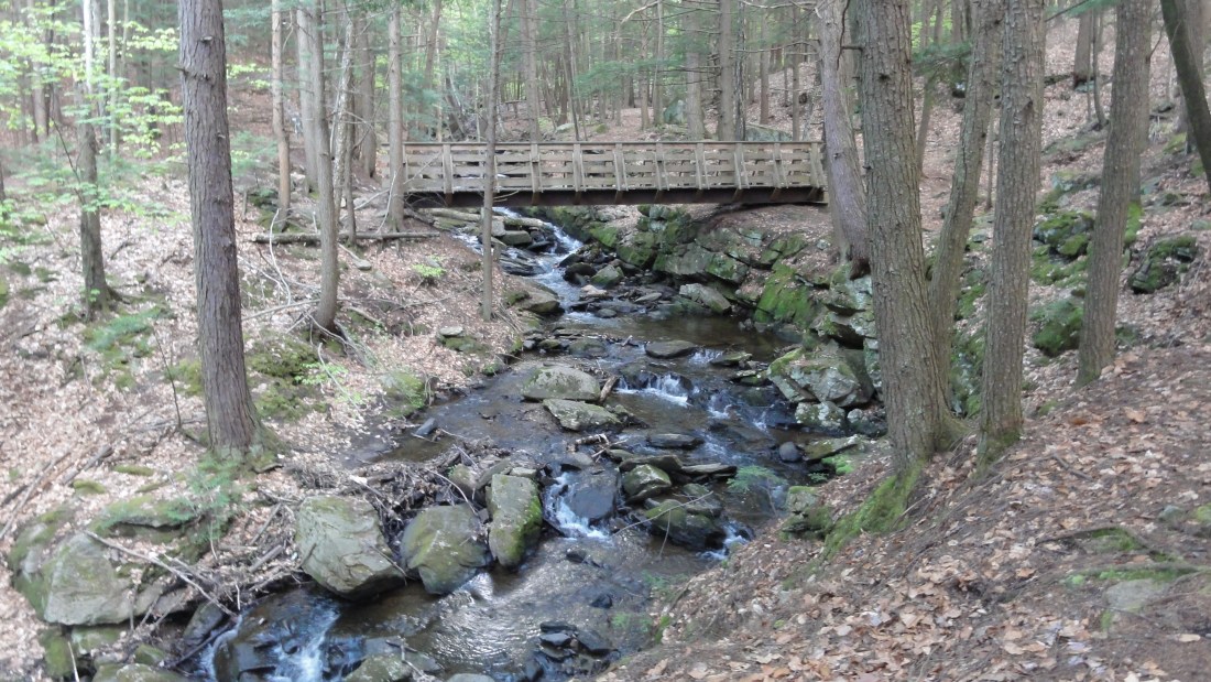
After our visits to the dinosaur footprints and The Rock, Fossil, & Dinosaur Shop, Dana and I headed back to New Hampshire to our secret lakeside geologist lair. On the drive back, we stopped at the Chesterfield Gorge. Although there has recently been some illegal activitiy at the gorge, during our visit Dana and I didn’t encounter anything more dangerous than an overly friendly golden retriever who wanted head scratches. I was happy to see that the gorge is back to being a peaceful natural retreat. I think my mother’s claims of the “danger” of the gorge were perhaps somewhat exaggerated.
Dana and I hiked the 0.7 mile loop trail along the gorge, stopping frequently to investigate the gorge’s intriguing geology. The gorge contains a most unusual looking stream. Most of the time, the bedrock found in streams and rivers is smooth (and often covered in sediment), and the rocks found within streams and rivers are rounded. River and stream rocks are generally worn down and rounded by physical erosion caused by the passage of water over them. However, the rocks at the gorge are not very round. They generally have sharp, square edges that indicate that the stream is fairly young (or just hasn’t been in contact with this bedrock very long) since there has not been enough time for physical smoothing of the rocks.
Sharp, square edges on those gorge rocks.More sharp, square rock edges.More square rocks.
Dana and I made our way along the trail to the first bridge across the stream:
The first bridge. Thou shall pass.
Before crossing the first bridge, we decided to take a closer look at the gorge’s rocks. The rocks are highly-weathered, and many are covered in moss. So, we had to exercise the good science of rock-breaking:
A weathered, moss-covered rock with a freshly-broken rock on top. Penny for scale.
Unfortunately, my rock hammers and other rock-breaking supplies are all in South Africa, and Dana packed carry-on for her trip and couldn’t bring her rock hammer. So, we had to improvise a bit with the rock breaking:
Throwing one rock against another.
Rock breaking by throwing is not as effective as rock breaking by hammer, so we also gathered up some rock samples to break later. The next afternoon, we borrowed a hammer from my dad’s stash of tools and did a little more advanced rock breaking. A word of advice: in the below photos, I set a bad example. Rock breaking should ideally be done with closed-toed shoes and long pants (to prevent injury from stray rock shards), but I did remember the essential eye protection (wrap-around sunglasses, in this case).
Breaking rocks in sandals. Don't try this at home, kids! A little more aggressive rock breaking. Dana, breaking rocks in more sensible rock-breaking attire. Excited about the rock-breaking results.
Here’s what we saw when we broke the gorge rocks:
Gorge rock #1. Gorge rock #2.Gorge rock #3.
So, what type of rock is found in the gorge? Looks like a metamorphic rock (fairly low grade) that perhaps used to be a granite or granodiorite. I managed to find a little more information about the gorge rock type by plotting the location of the Chesterfield Gorge on top of a geologic map of New Hampshire. I found the New Hampshire geologic map on the USGS website here, and I imported the map data into Google Earth. Pretty neat, huh? It’s actually quite easy to do– just download the .kml file, put it into Google Earth, and then you can look at the geologic map as Google Earth layer. Then, you can just click on a geologic formation, and an internet browser window will open with the information for that particular formation.
Below are some maps that I made in Google Earth showing the gorge location. First, here are some regular Google Earth images:
Google Earth image, showing the location of the Chesterfield Gorge in the state of New Hampshire.A zoom-in of the previous Google Earth image.
Now, let’s take a look with the New Hampshire geologic map added as a Google Earth layer:
The geologic map for New Hampshire as a Google Earth layer. Pretty neat, huh?A zoom-in on the geologic map, showing the location of the Chesterfield Gorge.An even closer zoom in. The gorge parking lot area is indicated by the marker.
The marker in the above maps indicates the location of the parking area for the gorge, which is located in the orange formation. If I click on the orange layer in Google Earth, I find that the parking lot is located on the Ammonoosuc Volcanics, which is a Middle Upper Ordovician unit described as,
Part of the Central Maine Composite Terrane (Central Maine Trough) – Variably metamorphosed sedimentary and volcanic rocks of greenschist to granulite facies, locally migmatized. Area includes structural belts between the Monroe fault on the west and the Campbell Hill fault on the east; that is, the Bronson Hill anticlinorium, Piedmont allochthon, Kearsarge-central Maine synclinorium, central New Hampshire anticlinorium, and Rochester-Lebanon (Maine) antiformal synclinorium. Ammonoosuc Volcanics = 461+/-8 U/Pb per J.N. Aleinikoff, oral commun., Feb. 1994.
Since the trail to the gorge leads away from the parking area, I believe that at least part (all?) of the actual gorge is actually located in the pink layer. When I click on the pink layer in Google Earth, I find that the pink layer is Granite/Granodiorite/Tonalite of Late Ordovician Age. The unit is described as,
Part of the Oliverian Plutonic Suite (Late Ordovician) – Pink, weakly to moderately foliated, locally porphyritic biotite granitoids found in mantled gneiss domes. Mafic varieties contain hornblends. Variably metamorphosed up to amphibolite facies. Oliverian Plutonic Suite: Keene and Surry dome intrusive rocks = 444+/-8 U/Pb per NH020. Warwick dome intrusive rocks = 444+/-8 U/Pb per NH020.
So, I believe the rocks that Dana and I saw at the gorge are from the pink formation. The rocks aren’t particularly pink-colored at the gorge, but they do seem to be granites/granodiorites/tonalites (the rocks seem to contain a fair amount of plagioclase and biotite, so my guess is granodiorite although I’d really need to take a closer look, perhaps employing a thin section– any opinions based on the rock pictures?) that have been metamorphosed somewhat. I’m assuming that the ages above (based on U-Pb dating) are in millions of years, so the gorge rocks are nearly half a billion years in age. Such an old age isn’t unusual for bedrock. Nevertheless, I still find myself somewhat in awe that these rocks originally formed nearly half a billion years ago. What history is exposed in the gorge! As a quick aside, when people ask me why I became a geologist, I sometimes say, “Well, I always liked history. And geology is really ultimate history, if you think about it. Geology is the study of the history of our planet– and other planets and planetary bodies.”
So, why do such old rocks host such a young stream? Clearly, the stream hasn’t been in contact with the bedrock very long or else the metamorphic gorge rocks would be worn smooth. I searched and searched for some academic papers on the formation of the Chesterfield Gorge. However, despite spending quite a bit of time using search tools such as GeoRef and Google Scholar, I didn’t find any scientific papers on the gorge. If anyone knows of any publications on the gorge’s geology, I would be most grateful if you would direct me to them. I couldn’t even find the gorge in my Roadside Geology of Vermont and New Hampshire book.
The best information I could find on the gorge’s origin is a PDF of an information pamphlet published by New Hampshire State Parks. The brochure indicates that the gorge is located along a fault (I’d love to bring Callan to the gorge to take a look at the structural geology) and that Wilde Brook (never knew the stream was called that until I read this brochure) is a superimposed stream that originated from glacial meltwater ~12,000 years ago. The sediment and gravel that once covered the metamorphic bedrock have been eroded by the young stream (I presume 12,000 years is fairly young for a stream? Perhaps not?), and now the metamorphic bedrock is slowly being eroded.
There is certainly some evidence that there was once a retreating glacier in the Chesterfield Gorge area. For example, just look at this enormous glacial erratic:
A glacial erratic boulder, just a few feet from Wilde Brook.
After Dana and I spent some time breaking rocks at the first bridge, we made our way down to the second bridge. Along the way, we saw some beautiful scenery:
After a short hike, we found ourselves at the second bridge. When we arrived, we found that we had a slight problem:
The second bridge. Thou shall not pass.
Since we are intrepid geologists, we decided to ford the stream rather than backtrack:
Venturing off the beaten path. Caulking the wagon and floating didn't seem necessary.Dana looked a little nervous before the stream crossing, but she made it just fine.
After fording the stream, we headed back up towards the parking area. On our way out, we had another look at the first bridge:
Peaceful and pretty.
And we also found some interesting biologically-assisted rock erosion:
Tree root style rock erosion.More tree root style rock erosion.
And we saw some interesting mushrooms:
Pretty fungi.
And we found a tree growing in a neat shape:
Strangely shaped tree, with geologist for scale.
All in all, Dana and I had a good day of geologizing. We saw dinosaur footprints, visited a kitschy rock shop, and explored the geology of a gorge. After this full day, we picked up a pizza and headed back to our lakeside geology lair to watch Dr. Who. Next up: Day 2 of our georneys!
The front of the Rock, Fossil, & Dinosaur Shop, complete with naked (non-feathered) velociraptor.
Note: I convinced my Geokittehs co-author Dana Hunter to fly from Seattle to New Hampshire to visit me for a few days. I handed in the final version of my PhD thesis last Friday afternoon, and Dana arrived last Saturday to help me celebrate. This is Part II of my description of the fun georneys we had together during Dana’s visit.
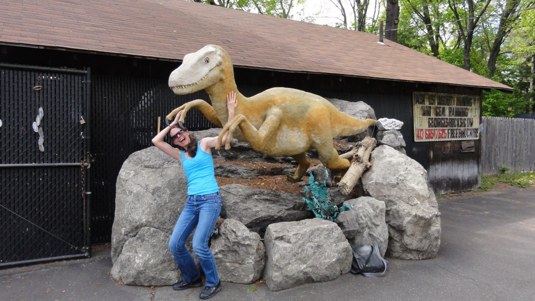
After our visit to the dinosaur footprints, Dana and I headed to a place called The Rock, Fossil, & Dinosaur Shop in Deerfield, Massachusetts. I have fond memories of visiting this shop as a child. The shop has many interesting minerals, fossils, and other geology-themed items for sale, which are advertised with a general focus on science and with a minimum focus on the crystal healing, energy balancing, totem stone, etc. woo-woo that is sadly promoted at many otherwise excellent rock shops. The shop also offers a number of other cheesy, geology-themed activities. You can “pan for minerals” in a water sluice located out front. The shop attendant tried to sell us on panning, but Dana and I were not very interested in panning bags of sand spiked with amethyst crystals and small ammonite fossils. We told the shopkeeper we liked to pan in real dirt for our geological treasures. However, I do remember enjoying the fake panning as a child. The shop also features a mining adventure and a backyard full of fake dinosaurs.
One of the fossils (or maybe a cast?) for sale. Giant ammonites from Morocco. Moar fossils. Dana, about to be eaten by a velociraptor.
Dana and I enjoyed our visit to the shop, but I was very sad to see that the shop is now very poorly maintained compared to my memory of it. At first I wondered if I was just remembering the shop through memories glorified by the glow of childhood delight. However, looking at the shop website pictures— which are clearly dated by several years– it’s apparent that the shop has deteriorated. The paint on the shop sign is cracked and peeling, the shop merchandise quantity and quality are declined (parts of the shop seem half-empty now), and the dinosaurs are in a sorry state of disrepair. Sadly, the shop attendant (who I hope was not the owner) didn’t seem to know even basic geology and mineralogy. I’m not sure what happened to the shop– perhaps it has changed ownership or been hit hard by the economic decline.
A sign of the shop's decline #1: a duct taped dinosaur.A closer view of the duct tape repair. A sign of the shop's decline #2: Willy mammoth bone? Hmmm...
Nevertheless, Dana and I had a good time during our visit. We had great fun taking pictures of the dinosaurs:
Dinosaur heads.Stegosaurus in the woods.Jurassic Park? Ankylosaurus. Pachycephalosaurus.
I made a triceratops friend:
My new friend.
And Dana found a new boyfriend:
I really hope this doesn't mean the shop is promoting the whole man-with-dinos thing.
While we skipped the panning and the mine tour, Dana did buy a few mineral samples, and I bought three stuffed animal dinosaurs: a velociraptor, a Utahraptor, and a triceratops. The velociraptor and Utahraptor even have a bit of fluff on them– I’m not sure if they’re quite feathery enough, but at least they have some feathers.
My new dinosaur friends. I think they need to become friends with Paleontologist Barbie.
I convinced my Geokittehs co-author Dana Hunter to fly from Seattle to New Hampshire to visit me for a few days. I handed in the final version of my PhD thesis on Friday afternoon, and Dana arrived last night to help me celebrate. So far, we’ve been having a ball. You can expect several forthcoming posts about Dana’s visit, both here on Georneys and over at Dana’s blogs Rosetta Stones and En Tequila Es Verdad. For now, I thought I would share just a few pictures from the first full day of our adventures.
In this post, I’ll share some pictures from our visit to the dinosaur footprints, which were quite impressive. In the photos below, I’ve indicated the locations of the dinosaur footprints with green markers (glass beads from the dollar store) since the footprints are sometimes difficult to see.
Dinosaur footrpint #1Dinosaur footprint, with my foot for scale. A trackway of footprints. If you look closely, you can see the green markers indicating the footprints.Footprints near ripple marks. More ripple marks.
Dana and I aren’t paleontologists, but we think we have some idea how the tracks were made. We think it went something like this:
A scientifically accurate reconstruction of the events leading to track formation (we are joking, obviously 🙂 )Yummy. Epic dinosaur-army battle.
Alternatively, the tracks could have been formed by a Danaraptor:
Researchers believe these prints were left by small groups of two-legged, carnivorous dinosaurs, up to 15’ tall. The entire Connecticut River Valley – which scientists believe was a sub-tropical swamp a “mere” 190 million years ago – has long been recognized for its wealth of prehistoric footprints.
The first dinosaur prints to be scientifically described are still here to be seen, preserved in sandstone* since this valley was a sub-tropical mix of wetlands and shallow lakes, 190 million years ago. The larger Eubrontes prints were likely made by ancestors of the great Tyrannosaurus rex, standing up to 15’ tall and 20’ long. You can see hundreds of fossils not only from the four distinct two-legged dinosaurs, but also stromatolites, fish, plants and other ancient beings. Finally, look for the 20+ dinosaurs trackways, which formed the basis for the novel theory that dinosaurs travelled in packs or groups.
*Note: I’m not convinced the rock is sandstone– it looked more like siltstone or mudstone to me. Can anyone confirm the rock type? When I have the time, I’ll track down some scientific references.
The dinosaur footprints are located along a beautiful section of the Connecticut River. After we had our fun looking at the tracks and doing our “scientific reconstructions,” we went down next to the river edge for awhile.
A pretty house along the CT River. On the tilted riverbank. Another view of the tilted rocks along the riverbank. Sedimentary, my dear Watson.
Red and white sandstone with casinos in the far distance, Las Vegas, July 2011.
For the final picture in geology picture-a-day week here at Georneys, I’ve selected a landscape from Red Rock Canyon, Las Vegas. The canyon’s name originates from the color of fossilized sand dunes that have been oxidized, converting the Fe (iron) in the rock from a 2+ to 3+ charge, which changes the color of the sandstone from white-tan to bright, rusty red. Recently, Red Rock Canyon was in the news because hikers stumbled across some dinosaur footprints, the first to be found in Nevada.
Although I am not generally very fond of cities or casinos, I have a soft spot in my heart for Las Vegas. In fact, I travel to Las Vegas often. I’ve traveled to Las Vegas a couple of times for geology field trips, and every year I spend a few days in Las Vegas to attend The Amaz!ng Meeting, a meeting founded by James “The Amaz!ng” Randi— a conjurer, writer, advocate for reason, and fighter of pseudoscientific nonsense. I’ve known Randi for many years, and I spent a couple of semesters back in undergrad working for him as an intern. I feel very fortunate to be able to call him a dear, dear friend. If you aren’t familiar with Randi’s work, I highly recommend reading some of his books. Some of them are even available for Kindle— and on sale for the holiday season!
As much as I enjoy seeing Randi and attending The Amaz!ng Meetings, the sparkle, fluorescence, garish carpeting, temperature control, liquor scent, smokey haze, and ching-ching-ching of a Las Vegas casino start to drive me crazy after a day or two. So, whenever I attend The Amaz!ng Meeting, I try to escape to Red Rock Canyon for an afternoon or two. Red Rock Canyon is about a half hour drive from the casinos and provides a peaceful, beautiful, and geologically interesting escape. Over the years, I’ve even led a few geologic field trips to Red Rock Canyon for Amaz!ng Meeting attendees. I’m not sure if I’ll be able to attend the 2012 Amaz!ng Meeting, but if I do I’ll be sure to take a quick trip out to the red, red rocks.
Here are some more pictures from my 2011 visit to Red Rock Canyon. I never did write up a post about the geology of Red Rock Canyon, but I promise to do so sometime! And, in case you missed them, here are my other geology pictures from this week: Monday, Tuesday, Wednesday, and Thursday.
Well, that wraps up geology picture-a-day week. I’ve enjoyed posting these geology pictures so much that I’m actually going to add a new weekly feature to Georneys: the Monday Geology Picture! Every Monday, I’ll post an interesting– and perhaps pretty– geology picture from my georneys (geological journeys) that will help inspire and motivate me for the work week ahead. As I finish up my PhD over the next few months, I’m not sure how much time I’ll have for regular blogging. I’ll do my best to blog when I can– mostly when I need a study break, I imagine– but I’m going to cut myself a little bit of slack over the next few months. If the Geology Word of the Week doesn’t appear some weeks, it’s because I’m feeling overwhelmed by my thesis. I should be able to keep up with a weekly geology picture, though– and hopefully some other more substantial posts now and then!
I hope you’ve enjoyed the pictures this week! Thanks to everyone who joined in and also posted geology pictures on their geoblogs. I’ve enjoyed seeing all of your pictures as well. If you haven’t already participated, it’s not too late to post a Friday Geology Picture!
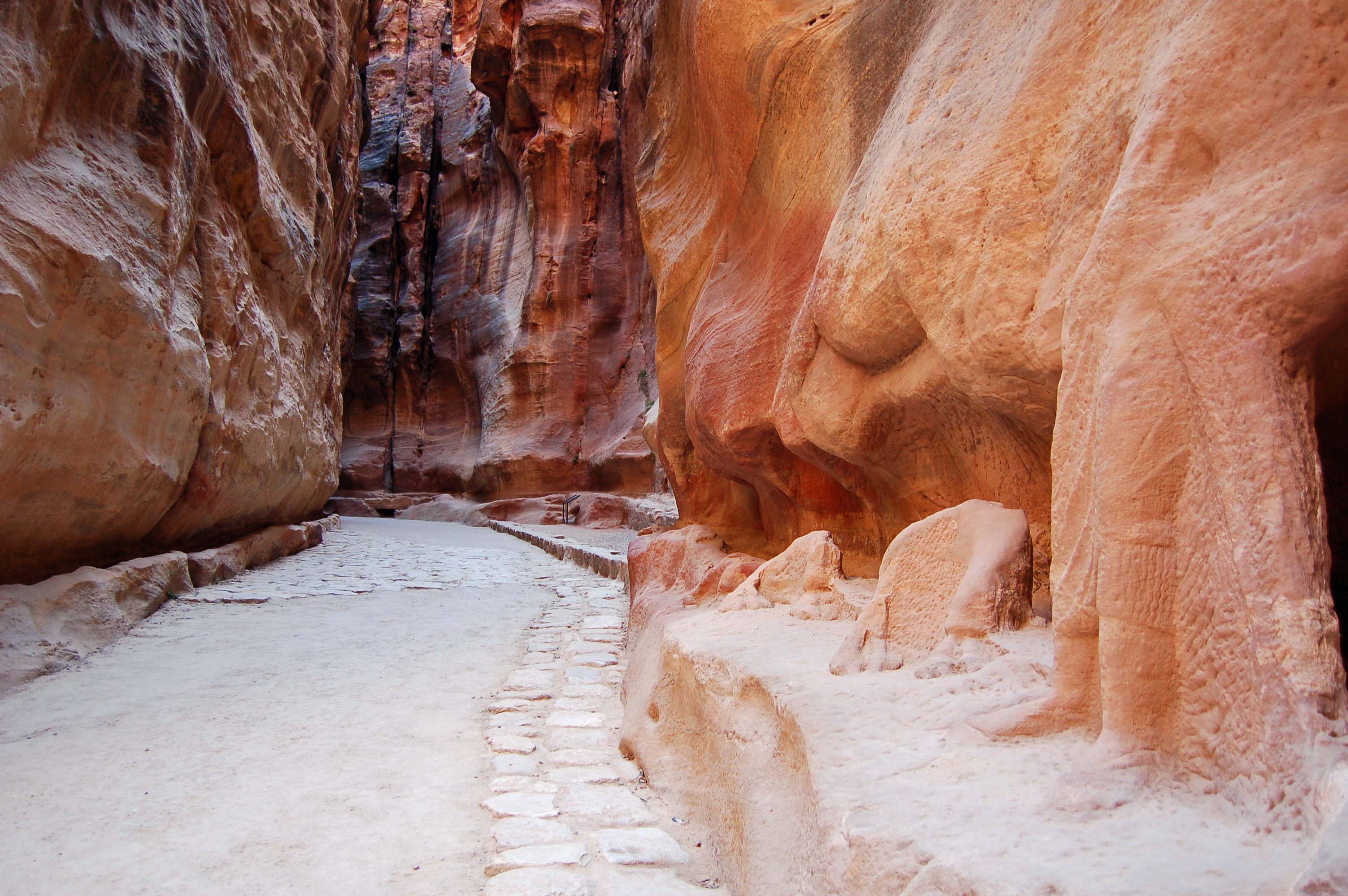
Remnants of ancient statues carved out of the sandstone walls of the Petra Siq, Jordan, August 2007.
Geology picture-a-day week continues here at Georneys. Today’s geology picture comes from one of my favorite places on Earth: Petra, Jordan. Petra is an ancient Nabatean city nestled in a broad valley that is protected by steep sandstone terrain. Petra is accessed by the Siq, a narrow canyon through the sandstone. The geology of the Siq is impressive enough: the walls of the canyon reveal beautiful, red rose colored sandstone which contains cross-bedding, concretions, quartz veins, and other interesting textures. However, the Siq is made even more impressive by the archaeological artifacts it contains: ancient water aquaducts that run along the sides of the canyon (see the background of the above picture), windswept stairs leading to small niches carved out of the rock, and even remnants of what must have been large and impressive statues. In the picture above, you can see the remnants of a sandstone statue of a man leading a camel– but only feet and hooves remain. The small archaeological artifacts found in the Siq hint at the impressive wonders that are found within the city of Petra itself; the Siq teases visitors and leads them along in anticipation.
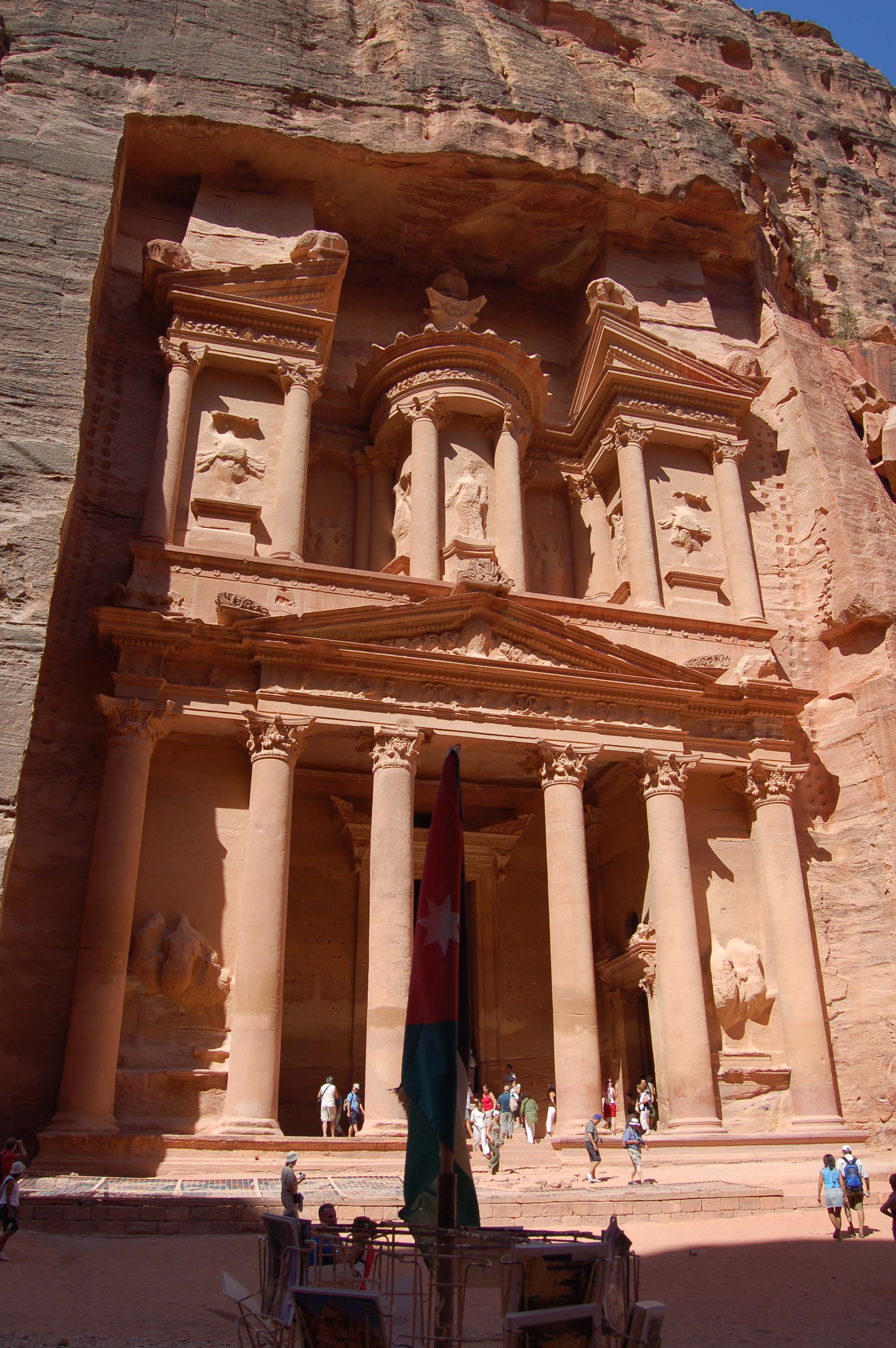
For those of you who have never heard of the Petra or the Siq before, you might recognize the end of the Siq as well as the impressive Al-Khasnah or “The Treasury” building from the movie Indiana Jones and the Last Crusade. Petra and The Treasury were also visited by my favorite cartoon explorer: Tintin! Speaking of Tintin, is anyone else excited for the Tintin movie that’s coming out very soon? I am!
Here’s what Tintin saw when he reached the end of the Siq:
And here’s what I saw in 2007 when I reached the end of the Siq:
The end of the Siq revealing a sliver of The Treasury. Petra, Jordan, August 2007.Astonished tourists gazing on The Treasury for the first time. Petra, Jordan, August 2007.The Treasury! Petra, Jordan, August 2007.
Petra is a truly remarkable place, both in terms of geology and archaeology. I could spend days upon days there. Here’s a few more pictures from my 2007 visit to Petra.
And, in case you missed them, here’s my other geology pictures from this week: Monday, Tuesday, and Wednesday. If you follow my twitter feed, I’ve been trying to retweet the geology pictures posted by other geobloggers. If you haven’t already, feel free to join geology picture-a-day week, even if you missed the first part of the week. The more geology pictures, the better!
Geology students investigating the underside of a large coral boulder, Barbados, June 2009.
Geology picture-a-day week continues here at Georneys. Today’s picture shows an impressive boulder of coral on a beach in Barbados. The lowermost part of the boulder has been undercut by wave erosion, providing a perfect nook for some geology students to take a closer look at the fossilized coral preserved in the boulder. The top part of the boulder has some soil and vegetation that has developed– a miniature island ecosystem!
I visited this Barbados beach in 2009 as part of a class field trip for the Geodynamics Course at Woods Hole Oceanographic Institution. Graduate school is hard work sometimes, but the field trips have definitely been a nice benefit! As part of the yearly Geodynamics Course, I’ve been on three field trips– one to Costa Rica, one to Barbados, and one to Switzerland and Italy.
Here’s a closer look at the fossilized coral in the boulder in the above picture:
A close-up view of the coral boulder, Barbados, June 2009. No scale- sorry ab0ut that!
If you missed them, here’s Monday’s picture and Tuesday’s picture. Several geobloggers have joined the geology picture-a-day meme. Even if you missed the first two days, feel free to join in today!


