Geology Word of the Week: S is for Speleothem

Posing with a pseudostalagmite, Oman, January 2009.

def. Speleothem:
An encompassing term used to describe all types of chemical precipitates that form in caves.

If you’ve ever been in a cave, you’ve probably seen speleothems. Speleothems generally precipitate from groundwater which has percolated through the bedrock surrounding the cave and leached various elements and compounds. When the enriched water reaches the cave, changing conditions (a large open space has very different pressure and temperature than pore spaces in bedrock) allow gases, such as carbon dioxide, to escape from the water. Evaporation can also occur. The changing composition of the water encourages the (usually very, very slow) precipitation of speleothem minerals from cave waters.

Chemically, the speleothems which form in a particular cave are similar in composition. Most caves are formed in limestone, and so the speleothems will generally be formed of calcite, the dominant mineral in limestone. However, depending on how and where the speleothem is precipitated, it can take on a variety of shapes. Scientists and other cave explorers have given different names to these various morphologies. Examples of speleothems are stalactites, stalagmites, flowstones, cave coral, cave drapery, cave curtains, and cave crystals. There are dozens of names for various cave mineral formations, so speleothem is a nice catch-all phrase for geologists to use.

Here is a great picture (from Wikipedia) of some of the most common types of speleothems:

Photo by Dave Bunnell of some common speleothems. Taken from Wikipedia here. Click photo to enlarge.

Most speleothems form over thousands upon thousands of years. Thus, you shouldn’t touch or remove speleothems unless you’re doing so for legitimate science. Even when collecting speleothems for science, one should be conservative. Geologists should take small samples and obtain the necessary permissions. Fortunately, for my own research in Oman I am often able to collect speleothems which have fallen on the ground and are no longer growing.

At the top of this post is a picture of me with a stalagmite in Oman. I didn’t sample this one, but I did sample some of its neighbors. This particular stalagmite isn’t forming in a true cave but rather in an open hallow underneath a layer of rock. Water percolated through the layer of rock and formed speleothems in the hallow underneath. The speleothems I study in Oman are thus really pseudospeleothems– they are not in true caves but rather in little overhangs and hallows.

Now, for those of you who still confuse stalactite and stalagmite, here’s a reminder of something you probably learned in grammar school but may have forgotten by now:
StalaCtites hang tight (or tite) to the Ceiling while stalaGmites grow up from the Ground.

Finally, below are few more pictures of some Omani pseudospeleothems. These pseduospeleothems are forming in overhangs in travertines (carbonate precipitates) which are forming at the surface of the peridotite layer of the ophiolite. Be sure to click on the two panoramas to enlarge them. Note the location of the pseudospeleothem column in the two panoramas. Many pseudospeleothems are located in the overhang around this column. The last picture has my colleague Lisa standing next to this column for scale; this shows the enormous size of the travertine deposit.

Travertine pseudospeleothems, Oman, January 2009.
Water dripping from a pseduospeleothem straw, Oman, January 2009.
Panorama of Wadi Sudari Travertine I, Oman, January 2010.
Panorama of Wadi Sudari Travertine II, Oman, January 2010.
Lisa standing next to an enormous column of travertine, Oman, January 2009.

The Mantle MOJO

Mixing of classic mantle reservoirs in tetrahedron space, Figure 2 from Hart et al. (1992). Click to view larger.

If I ever name a mantle reservoir, I am going to call it the MOJO. Why? Because I would love to give a geochemistry talk where I discuss such-and-such volcanic rock having a mantle MOJO signature. The mantle MOJO will be the sexiest of mantle reservoirs. All geochemists will hope their rocks have a little MOJO in them. For those of you who are not familiar with meaning of the slang word “mojo,” I recommend watching the Austin Powers move “The Spy Who Shagged Me” or consulting the trusty urban dictionary

My only problem in naming this mantle reservoir is, of course, coming up with a good definition of the acronym. Well, and actually finding some evidence for the proposed reservoir. But really, this is such a great mantle reservoir acronym that I’m sure we can find a place for it in geochemistry.

Here are some ideas:
MOJO = Mantle Original Juvenile Order
MOJO = MOderately reJuvenated Orb
MOJO = Mantle Overly Juvenated Offshoot

Honestly, I’m not happy with any of these acronyms. Any better proposals?

Those of you who are not mantle isotope geochemists may be wondering: what is a mantle reservoir? A mantle reservoir is basically a region of the Earth’s mantle with a specific geochemical (generally isotopic) fingerprint. The classical model for mantle reservoirs is that they are broad regions of the mantle that have specific geochemical fingerprints– they are enriched in one element or depleted in another element– because of their origin and geochemical history. Because geologists cannot directly sample the Earth’s mantle, they use geochemical fingerprints of mantle sources found in rocks at the surface to infer the composition of the inaccessible mantle.

To explain this further, I will quote a paper I wrote back in undergrad:

“One of the methods modern scientists use to learn about the chemical composition of the Earth’s interior is the analysis of isotopic compositions in rocks on Earth’s surface. Geochemical analysis of radiogenic Hf and Nd [and other] isotope ratios in erupted lavas is a powerful tool for examining the processes governing the geochemical evolution of magma deep within the Earth’s mantle. Isotope compositions and their ratios are minimally affected by the immense physical stresses imposed at great depths in the Earth’s interior, the processes of magma upwelling to the crust, and the final eruption at the Earth’s surface. Therefore, these analyses can be used to infer the compositions of the igneous source material as well as how these sources mixed and melted to form the rocks on the surface. Combined with major and trace element data, Hf and Nd isotope ratios can even be used to determine the degree of melting that occurred.”

As geochemists collect more and more isotopic data, they are realizing that the mantle reservoirs are not as simple as first proposed, mostly back in the 1980s by Stan Hart and other geochemists. Like many scientific models, the model of the mantle reservoir is one that seemed simple and straightforward for many years but which now requires modification and re-analysis now that scientists have much more data and understanding. The mantle seems to be really, really heterogeneous- there are probably not just a few large mantle reservoirs but rather many small mantle reservoirs. Perhaps in the near future, geochemists will talk about a source having the general geochemical “flavor” of one of the classic mantle reservoirs rather than originating from a specific, somewhat magical mantle source. Oh! I have a sudden inspirational idea. Maybe geochemists can say that a source has the “mojo” of a classic mantle reservoir.

I am currently writing a paper about evidence for extremely small-scale mantle heterogeneity in Iceland. One of these days (hopefully soon!) I’ll actually finish and submit the paper. I’ll be sure to blog about the paper once it’s published, but until the paper is out I won’t talk about the results in detail.

Mantle end-members in Nd-Pb isotope space. Data from oceanic basalts is plotted with the general locations of the end-members marked. Data compiled by Stracke et al. (2003). Click to view larger.

For those of you who are not familiar with them, these are the classic mantle reservoirs:

-EMI: End-member I 
Low Nd, Pb, & Hf, intermediate Sr isotope values
Originally, EMI was thought to be subcontinental lithosphere. However, many geochemists now believe that EMI is better represented by pelagic (deep-sea) sediment that has been recyled into the mantle.

-EMII: End-member II
High Pb & Sr, intermediate Hf, and low Nd isotope values
Most geochemists agree that EMII is subducted continental material.

-HIMU: High “mu” or μ
Very high Pb, intermediate Nd, Hf, & Sr isotope values
Mostly defined as a source with high 206Pb/204Pb. Since 206Pb decays from 238U, this means that the source had high U/Pb (relative to “normal” mantle). Note that μ = 206Pb/204Pb in geochemistry speak.
There are various ideas about what can produce high U/Pb in the mantle. One option is subducted oceanic crust that became enriched in U/Pb during subduction. Other proposed origins of the HIMU signature are old, U-rich ocean crust (perhaps enriched because the ocean used to have more U?) and delaminated continental lithosphere.

-DMM: Depleted MORB Mantle
High Nd & Hf, low Pb & Sr isotope values.
Note that there is a nested acronym within an acronym here. MORB = Mid-Ocean Ridge Basalt.
DMM is “regular” mantle that has been depleted by the earlier extraction of the enriched continental crust. Perhaps I’ll blog about the geochemical relationships among continental crust, oceanic crust, and mantle another day. For now, just know that DMM is pretty much your run-of-the-mill mantle.

-FOZO: Focused Zone
Low Sr, high Nd & Sr isotopes.
If the FOZO exists, it probably is in the deep mantle, near the core-mantle boundary, and is a sort of ultimate source material for mantle plumes.
 
Elements discussed in this post:
Hf- Hafnium
Nd- Neodymium
Pb- Lead
U- Uranium
Sr- Strontium

References:
Dickin, Alan. 2005. Radiogenic Isotope Geology. Cambridge: Cambridge University Press.
Hart et al., 1992. Mantle plumes and entrainment: isotopic evidence. Science, vol. 256: 517-520.
Stracke et al., 2003. Theistareykir Revisited. G3, vol. 4, no. 2.

Temporal Disconnect: An Underwater Oceanographic Institution?

Martha’s Vineyard oceanview, Cape Cod, November 2008.

I was walking along the beach today in Woods Hole here on Cape Cod. I wanted some fresh air and felt like collecting some seashells. You always find the best seashells in the winter. There’s no one else on the beach, usually, so the biggest, most beautiful seashells will just be waiting for you there on the sand, perhaps tangled in some seaweed. As I walked the beach and looked for shells, I thought about how in the next century or two– at most– all of Cape Cod will be underwater.

I find it somewhat ironic that Woods Hole Oceanographic Institution (WHOI)– one of the leading research institutions studying oceans and climate change– will be one of the first places to go underwater once sea level rises, as it is currently doing and will continue to do over the next hundred years or so. The institution is built on the low-level glacial till of Cape Cod, and most of the scientists have offices with an ocean view. In the summer the scientists and graduate students often go down to the beach for a quick swim. Building an oceanographic instituion on the ocean makes sense, but if WHOI scientists and trustees were smart they’d begin investing in some property in the hills of New Hampshire. Why? Because that’s where the new oceanfront property will be not so long from now.

The scientists here at Woods Hole are very environmentally aware. The scientific parking lot is cluttered with bicycles and compact hybrid cars, a great contrast to the Land Rovers and SUVs that fill the nearby Martha’s Vineyard Ferry parking lot. Most people you encounter here acknowledge that climate change is occurring and that sea level will rise significantly in the near future.

Almost everyone here would agree that Cape Cod will be one of the first places to go underwater when sea level does rise significantly. However, no one seems to worry about the location of the oceanographic institution. At least, they don’t worry about it on a day-to-day basis. The scientists take their lunchtime strolls along the beach and play with their expensive mass spectrometers and PCR machines in their multi-million dollar labs. No one seems too worried about having to move all of these fancy labs and scientific equipment once sea level rises.

I am sure that at times Woods Hole scientists must wonder about what will happen to the oceanographic institution once Cape Cod is underwater.Yet, it is difficult to really worry about the institution on a day-to-day basis, even for those scientists who are actively studying climate change. I’ll speak now for myself: while I intellectually recognize that the sea is rising– and rising fast– I cannot wrap my mind around the effect of sea level rise on my own life. When I look at the ocean, I don’t see it rising. One day’s ocean does not appear different from the next day’s. Sea level rise occurs fast on the geologic timescale but still occurs quite slowly on the human timescale.

Human minds have not evolved to think on geologic scales. We are very well-adapted to thinking on the scales– both physical and temporal– that apply to our own short lives. If one cannot actually see the sea rising or anticipate it rising significantly within her own lifetime, it is difficult to become alarmed. One may have minor concern for one’s descendants, but that gut reaction of “Wow! The sea is rising, so I’d better run away” just doesn’t happen for an ocean that rises on the order of millimeters per year. You just can’t see the change occurring nor anticipate- in a gut way- its future influence on your life.

Honestly, I think this is why the issue of sea level rise and climate change is so difficult for many people– myself included– to become worked up about. I am a first-year graduate student now in the program at Woods Hole. I will graduate in four to five years**. Very likely, Woods Hole will not be underwater in five years. After I graduate, who knows where I may end up? So, I find it challenging to become concerned about sea level rise here on Cape Cod, at least in my daily life and routine. Once the waters are lapping at my office door, then I’ll become alarmed.

Jebel Misht: Accretionary Wedge #32

I am participating in my first Accretionary Wedge- yay! For those of you who don’t know, the Accretionary Wedge is a monthly “geology blog carnival” where geobloggers of all kinds are invited to blog on a theme.

I contemplated participating in the past two Accretionary Wedges, but I’m very busy with my thesis this winter. Therefore, I didn’t quite have enough time and energy to bake something for Accretionary Wedge #30 or to write about something I was surprised to learn for Accretionary Wedge #31.  This month’s Accretionary Wedge is easy, though! For Accretionary Wedge #32, I just have to post my favorite geology picture.

One of my favorite geology pictures (I have several- so difficult to chose!) is a picture of my favorite campsite ever. The picture below shows a makeshift campsite just off a road in northern Oman. The beautiful mountain in the background is Jebel Misht, one of several exotic limestones in the middle of the Samail Ophiolite. I was lucky enough to spend a few nights at this campsite in 2009 and 2010 as part of my PhD thesis fieldwork. One of my field sites, located near the small village of Al-Bana and close to the Misht campsite, has been named “Jebel Misht Travertine” by my research group.

Jebel Misht is a popular climbing destination. Making your way up the tall southeast cliff is not an easy task.  When a French team of climbers accomplished the first successful ascent of Jebel Misht in 1979, the Sultan of Oman arranged to have the climbers picked up by helicopter from the top of the mountain and whisked off to the palace for a celebration. Jebel Misht means “Comb Mountain” in Arabic. Indeed, the mountain’s majestic cliff resembles a gigantic comb resting peacefully amidst the seafloor rocks of the ophiolite.

Jebel Misht campsite, Oman, January 2009.

Geology Word of the Week: R is for Rock

“In spite of the difficulty in defining rocks, most rocks are easily recognized when you see them, and most are made of minerals or mineral-like substances. They are usually solid, hard, and heavy, compared to the other materials you see and use daily.”
-From Rocks and How They Were Formed by, Herbert Zim, Golden Library of Science, 1961.

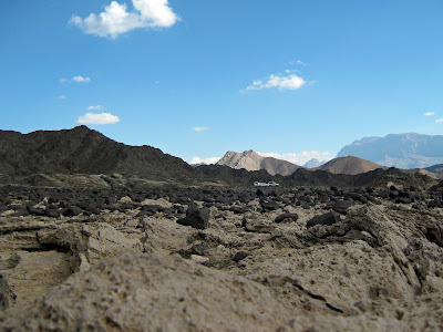
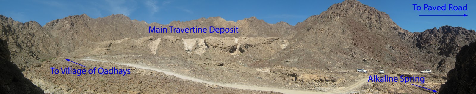
Carbonate rocks, peridotite rocks, mountains, and field vehicles, Oman, January 2010.

def. Rock:
1. A solid mass of matter– usually composed of one or more minerals or mineraloids– that occurs naturally on the Earth or another planet or extraterrestrial body.
2. What geologists study.

Sometimes, the simplest words are the most difficult to define. This is particularly true when it comes to basic words that have broad definitions. The basic stuff of our universe is innately understood by us but often difficult for us to describe. Words such as water, fire, air, plant, animal, person, rock– and many others– have encompassing, basic meanings that are understood by everyone. These words also have precise– yet still broad– scientific definitions. Yet, if you ask a person to define a simple word such as air or water, this person is likely to struggle somewhat. How do you define a basic, essential word whose meaning you understand instinctively more than intellectually?

When we define complex words, we usually describe them with more simple words.  For example, “petrology” is “the study of all aspects of rocks” according to my trusty Dictionary of Geology (Keary, 1996).  Other complex words can be defined with one-word synonyms. For example, the word “innate” (used earlier in this post) can be defined by synonyms such as instinctive, intrinsic, inherited, native, natural, and intuitive. However, simple words such as water and air and rock cannot be easily defined by one-word synonyms.

Yesterday evening I asked my geologist fiance Jackie for a geology word starting with the letter R. As some of you may have noticed, I am going through the alphabet for my geology words of the week. So far, I have made it from A is for Alluvium to Q is for Quaternary. My conversation with my fiance went something like this:

********
Me: “I need a geology word that starts with R.”

Jackie: “Huh? Oh- I don’t know. I’m sleepy.”

My fiance and I are temporarily living on different continents, so there’s a six or seven hour time difference. I usually call him late at night and wake him up for work, so he’s often sleepy when I call him.

Me: “I was thinking of regolith, but that’s sort of boring. And I already used the word alluvium, which is similar. I also thought about radioactive decay, but that’s too complicated. I think I want to write about that in some posts about how to date rocks.”

Jackie: “Huh. Well, what about rock?

Me, laughing: “Well, it is an important word for geology! How do you define a rock anyway?”

Jackie: “A silicate network… wait… uh… yeah, a silicate material…”

Me, interrupting: “But what about carbonates?”

Jackie: “Carbonates aren’t rocks.”

Me: “Not even limestone?”

Jackie: “Well, I guess limestone is a rock. Those carbonate alteration products you study aren’t rocks, though. They’re just gardening.”

Earlier in the phone call, Jackie and I had a conversation about how certain high-temperature metamorphic petrologists we’ve met refer to low-temperature surface metamorphism (the stuff I work on) as “gardening.” Not sure why exactly, but it’s become our new term for my thesis research.

Me: “I work on real rocks. And even if my carbonates aren’t real rocks, I also work on peridotites.”

Jackie: “Yeah, okay. Well, I guess a rock is a solid material… that… uh…”

Me: “Do anthropogenic materials count as rocks? Like man-made conglomerate?”

Man-made conglomerate is what we call cement that has little rocks in it.

Jackie: “No, I think rocks have to be naturally-occurring. Like minerals.”

Me: “Okay, so we have to say a naturally-occurring solid material… hmm. I’ll look up rock in my geology dictionary.”

While Jackie muttered some more about how he was sleepy, I consulted my trusty geology dictionary. I was surprised to discover that the word rock is not in my geology dictionary! There are words that contain rock– such as rockburst and rocksalt– but the word rock isn’t in the dictionary.

Me: “The word rock isn’t in my geology dictionary!”

Jackie: “I guess that’s not a very good geology dictionary. Now you definitely have to blog about this word.”
********

And so this week’s geology word was chosen. I did eventually find various definitions of the word rock in other geology books. From these definitions, I came up with the simple, broad definition above. Geologists, how do you define the word rock?

Below are a few definitions of the word rock from various geology books:

“Look for rocks. They are the materials of which the crust of the earth is made. They form the mountains and underlie the valleys. You see them when they have have been pushed or folded upward or when they jut through soil to form an outcrop. All minerals occur within rocks, and often are components of rocks.”
-From Rocks and Minerals: A Guide to Minerals, Gems, and Rocks (A Golden Nature Guide), 1957.

“Rocks are large masses of material making up the Earth’s crust; many are not solid, like soil and gravel. A rock may consist of just one mineral, like quartz, dolomite, or calcite. Some rocks do not have discreet minerals but are made of glasses. However, most rocks contain several minerals, or were formed from older rocks where these minerals were present.”
-From Collins Wild Guide: Rocks & Minerals, 2000.

“The difference between a rock and a mineral should be clearly understood. Rocks are the essential building materials of which the earth is constructed, whereas minerals are the individual substances that go to make up the rocks. Most rocks, therefore, are aggregates of two or more minerals. Thus, granite (a rock) is composed of at least two minerals (quartz and feldspar), though others are almost certain to be present.

If a single mineral exists on a large scale, it may also be considered a rock, because it may then be regarded as an integral part of the structure of the earth. Thus, a pure sandstone or quartzite rock contains only one mineral, quartz, distributed over a wide area. Other single minerals which are described in this book and are regarded also as rocks by this definition include anhydrite, dolomite, gypsum, magnesite, serpentine, and sulfur– all of which occur in huge beds or masses. Some rocks of this type have a different name from that of the mineral composing them. Thus, the mineral halite makes rock salt; calcite or dolomite can make up the rock called marble. Kaolinite composes many of the rocks we know as clay. Bauxite has been proven to be really a rocky mixture of several minerals, but many geologists still prefer to call it a mineral because of its uniformity.

In addition to these two classifications, rocks include natural glass, though it may be devoid of any actual mineral components. Obsidian, an abundant rock in Mexico and Iceland, is natural volcanic glass. Organic products of the earth, which cannot be called minerals because they are formed from plants and animals, are properly known as rocks. Coal, derived from partly decomposed vegetation, is a rock of this kind.”
-From How to Know the Minerals and Rocks by Richard Pearl, 1955.

“Minerals are the fundamental units of which rocks are composed, homogeneous solids of definite chemical composition, formed by natural inorganic processes. Such a definition includes ice as a mineral but excludes coal, natural gas, and oil… The term ‘mineral’ often has a more extended usage, and may be used to describe anything of economic value which can be extracted from the earth, even clay or coal. A rock, on the other hand, has no fixed chemical composition, is not homogeneous, and has no definite shape of its own. In most cases it will consist of mixtures of several minerals. Granite, for example, is composed of the minerals feldspar, quartz, and mica, but some rocks may be formed mainly from one mineral.”
-From Rocks and Man by Myra Shackley, 1977.

“Rocks make up most of the Earth on which we live. The mountains are built of rocks. The plains and oceans rest on deep layers of rocks. Even in outer space, there are rocks circling the sun like tiny planets.”
-From Rocks and What They Tell Us by, Lester del Ray, 1961.

“What are rocks?

Simply put, rocks are naturally occurring aggregates (collections) of minerals. What makes rocks so different is their diversity– they can range from masses of minerals formed by volcanic action, from eroded sediment,or from great pressures and high temperatures. Rocks are usually composed of more than one mineral, although in rare cases they can be entirely composed of a single mineral, in which case they are called monomineralic rocks.”
-From The Handy Geology Answer Book by, Patricia Barnes-Svarney and Thomas Svarney, 2004.

Finally, below is my favorite definition of rock that I have found in my geology books. Sorry for such a long quotation, but I just love the completeness of this definition of a rock.

“To the geologist, rock is the natural, solid material that makes up the earth. The first word ‘natural’ immediately eliminates man-made materials like cement, glass, brick, and steel, even though these all come from the crust of the earth.

The second word, ‘solid,’ rules out the air and other gases, the oceans, rivers, lakes, and other liquids. However, solids can be changed to liquids and gases by being heated; liquids and gases can be changed into solids by being cooled. The definition of a rock means solids at temperatures which normally occur in the earth’s crust.

Even this does not cover everything, because one of the most common chemical compounds on the surface of the earth may or may not be a rock, depending on its temperature. This chemical compound is water- H2O. Water makes up nearly three fourths of the earth. Most of it is in the form of a liquid, and while liquid water affects the rocks of the earth in many ways, water is not a rock. However, in the arctic and antarctic regions, and in the temperate regions during winter, millions upon millions of tons of water are a hard, frozen solid. In the antarctic, ice occurs in layers nearly two miles thick. Ice is, therefore, a rock, and geologists study the great ice fields just as they study other rock formations.

In speaking of rocks, geologists use the word ‘solid’ in its technical sense. A solid is matter that is not a liquid or gas. What the geologists would call ‘solid rock’ might seem strange to you. The wet sands on the beach and the sifting sands in the desert are a solid– and a rock. This is also true of the layers of mud and muck in the swamps, or the ash and cinders from volcanoes. They are rock also.

The third word, ‘material,’ brings no additional problems to the definition of a rock. But it may be well to point out that materials in the crust of the earth have two distinct origins. Most of the material in the crust of the earth is inorganic. This means that it is no way related to life or living things. Lava pouring from a volcano makes an excellent example of an inorganic material. So do the great masses of granite pushed miles into the air as part of the Rocky Mountains.

While most rocks are made of materials which are not or never have been alive, some rocks are organic– made by living things. Coal and oil deposits, for example, are the remains of ancient plants. Oil, you might say, is a liquid and therefore is not a rock. However, there are no great underground lakes of oil as some people imagine. The oil is usually soaked up in the pores of sand and other rocks. Under special conditions it will drain into wells where it is pumped to the surface. Millions of gallons of oil are locked up in rocks, especially in the oil shales of Alberta, Canada, and other places. Asphalt is another organic rock. Great deposits of it are found on the island of Trinidad.

Less well-known are the rocks which are formed from the remains of sea animals. Shells cemented together form several kinds of limestone. Sometimes these are shells of microscopic animals; sometimes they are larger shells.

Coral is another kind of rock made from living things. Coral animals take lime from sea water and build it into reefs in which millions upon millions of animals live. Islands of coral dot the South Pacific. A few microscopic plants and sponges have silica skeletons. Under certain conditions these, too, form organic rocks.

One final explanation, and the definition of rocks is about as complete as it can be. The definition implies that rocks are large masses of natural, solid material, big enough to form a distinct part of the earth’s crust.

Diamonds are not rocks, even though they are found in the crust of the earth. But if a whole mountain of diamonds was discovered, then it would be correct to call diamonds a rock. There are places where one can see mountains of marble, quartz, granite or limestone. You can find large beds of coal, shale or lava. These are rocks. There are many miles of rich soil, more miles of sand in the deserts and on the shores. They all make up major parts of the earth’s crust, so they are called rocks.

You may have noticed that the definition of a rock does not say anything about minerals. This is odd, for we commonly think of rocks and minerals as going hand in hand. Most often they do. However, all minerals are inorganic. They are all chemical compounds and therefore have definite chemical composition. Mixtures of minerals often do form enough of earth’s crust to be considered rocks. Granite, made mainly of three minerals– mica, feldspar, and quartz– is undoubtedly a rock.

There are also times when a single mineral may form a rock. Quartz is a common mineral. Some forms of sandstone are made up of 99 per cent pure quartz. In this and other cases the rock and mineral are made of the same chemical. This may also happen in the case of the mineral, calcite, which forms a kind of pure marble. Here again the rock and mineral are the same. Gypsum is another rock made of a single mineral. The mineral kaolin makes fine clay and forms still another kind of rock.

However, rocks may be made of materials which are not minerals at all. Volcanic glass or obsidian is not a mineral but frequently forms rocks. Coal, peat, and asphalt are not minerals but they are rocks.

In spite of the difficulty in defining rocks, most rocks are easily recognized when you see them, and most are made of minerals or mineral-like substances. They are usually solid, hard, and heavy, compared to the other materials you see and use daily.”
-From Rocks and How They Were Formed by, Herbert Zim, Golden Library of Science, 1961.

Technology Anachronisms in Science

MacDiff program running in a Mac Classic environment emulator on my Windows XP netbook, January 2011.

Ever since I starting doing geology research back in 2003, I have encountered technology anachronisms in science. I find these technology anachronisms intriguing, humorous, and- sometimes- frustrating. Often, the challenge of using technology in science is not keeping up with the latest-and-greatest technology but rather remembering or learning to use very old, outdated technology.

What is a technology anachronism? Basically, this is a piece of technology (e.g. a computer, a data reduction program, a mass spectrometer) that is old and out-of-date– sometimes wildly so– but which is still in regular use for any of a variety of reasons. A good example of a technology anachronism is the soon-to-be retired Space Shuttle. My senior year of high school, I remember reading a 2002 New York Times article titled “For parts, NASA Boldy Goes… on eBay.” Basically, in 2002 (and probably in 2011) the Space Shuttle was still using early 1980s computer technology. In order to keep the shuttle computers in good repair, replacement parts were sometimes needed. The problem, of course, was that 1980s computer parts were hard to come by in 2002. Thus, NASA would buy replacement computer parts on eBay and any other place they could scavenge them from.

So why did NASA go on eBay rather than just outfit the space shuttle with new computer systems? Well, you’ll have to ask NASA about that for an official answer, and I’m sure they did make some updates to the shuttle’s computer technology. However, I imagine that designing a space shuttle– even just part of a space shuttle– is such a long, rigorous process that it is more practical to maintain the outdated but tried-and-trusted technology rather than overhaul with new technology that would require significant energy to design, test, and implement.

About a year after I read the NASA article, I started participating in science research in a geochemistry lab down at Florida State University (FSU). I went down to FSU to work as a summer intern. For my project, I measured hafnium (Hf) and neodymium (Nd) isotopes in some post-shield basalts from Hawaii. I measured Hf isotopes on a very old mass spectrometer* that had been specially modified for the task. The computer that was hooked up to the mass spectrometer was early to mid 90s in vintage. Much of the running of the mass spectrometer was done by hand (physically pushing in the samples, initial settings and calibration), but the computer did have a program for measuring the isotopes. The computer program was difficult to use and full of glitches. I forget what code was used, but I think it was an old FORTRAN code that had been programmed by a graduate student or technician way back when. The results came out on an old dot matrix printer with the holes on the edges to move the paper along.

More recently, I have encountered a technology anachronism in the software program I am using to identify minerals in X-ray diffraction (XRD) scans of rock powders. To identify minerals, I am using a program called MacDiff. This is a great XRD analysis program– it’s free and works really well for basic mineral identification. There are other, very expensive programs with larger mineral databases and more capability. However, I don’t require this much analysis for my thesis, so MacDiff is fine. There is just one problem with the MacDiff software: the program has not been updated since about 2000. The program also only works on a Mac, but even that wouldn’t be a huge problem if it worked on a recent Mac. Actually, the program can only be run in the Mac Classic environment.

There are two options for working with MacDiff. The first option is finding an old Mac computer that can run the Mac Classic environment. This is not too difficult as many scientists have old Mac computers lying about, and worst case scenario you can always buy an old Mac fairly cheaply off eBay. The second option, which I decided to pursue, is to set up an emulator environment so that you can run the Mac Classic environment in a window on a modern computer. Setting up an emulator is a little bit tricky (well, for me anyway), but I had a computer savvy friend help me figure it out. Running MacDiff through an emulator works well with just a few problems. The emulator tends to crash if you do certain things in certain orders, but I’ve managed to figure out ways around the problems I’ve had with the emulator. I really wish that a scientist or programmer would update the MacDiff code so that it would run on a modern computer, but that coding represents a significant time investment, so it probably won’t happen anytime soon.

I have encountered countless more technology anachronisms in scientific research. In my experience, there are several reasons why technology anachronisms exist:

1. Money:
There can be a high cost in replacing technology. Scientists cannot afford to replace very expensive equipment– such as million dollar mass spectrometers– often. For example, here at Woods Hole Oceanographic Institution there is an ion probe** that is from the late 1970s. There is also a newer, fancier ion probe. However, since ion probes are so expensive and in demand, the old 1970s one is still run regularly.

2. Time and Effort:
Replacing technology and becoming used to new technology takes time, which scientists have far too little of these days. Sometimes, it is faster and easier to keep the old technology limping along rather than take the time to transition to new technology. As an example, if an extensive code has been written in outdated FORTRAN, many scientists prefer to keep working with the pre-existing FORTRAN code rather than take the time and effort to re-write the code in a new language.

3. Comfort:
Humans, scientists included, are often resistant to change. Like NASA space shuttle operators, scientists like working with tried-and-trusted technology. Sometimes, this means clinging onto a computer or code or machine longer than they should. Older scientists in particular can sometimes be unfairly critical and suspicious of new technology.

4. Compatibility:
Sometimes, using older technology is really the only option. For instance, if you are using an old ion probe you may need to use an old computer in order to be able to talk to that old ion probe. Similarly, if you are using a group piece of technology– such as MacDiff– that you cannot update on your own, then you may be stuck with old technology unless the whole research community makes an effort to update the technology.

There will always be anachronistic technology in science, if only because the pace of technology development is so rapid these days.This is especially true when it comes to computers. The day you buy your shiny new laptop, this laptop is already out-of-date. New and better computers and computer-like gadgets– smartphones, electronic book readers, tablet PCs– are constantly being released. New software programs (Microsoft products, internet browsers, blogging platforms) come out every couple of years, and updates to these commonly-used software programs come out all the time.

So, whatever technology you purchase for your science, it’s likely to be out of date by the time you install it in your laboratory.

*For mass spectrometry geeks, the machine was the Lamont Isolab 54 Secondary Ionization Mass Spectrometer (SIMS).

**For ion probe geeks, the older ion probe is the IMS 3f. WHOI also has a IMS 1280.

How Not to Lose Wireless GPS Receivers

In Fall of 2005 I participated in “The Stretch”, the trimester-long geology field camp run by Dartmouth College. In recent years, the field camp has taken place in the western continental US. Many years ago, the field camp also took place in Central America, Hawaii, and other locations.

The year I went on The Stretch, we studied geology in Wyoming, Montana, Utah, Nevada, California, and Arizona. We drove thousands of miles and did dozens of geology field projects, ranging from small one-day assignments to week-long mapping exercises. I recently discovered my old field notebooks and journal (I often wrote about my day in the evenings) from The Stretch, so I’ll probably blog occasionally about my field camp experience and post some pictures. I’ve already written about our ternary personalities exercise.

I had an amazing time on The Stretch. I was very lucky to spend an entire trimester studying geology with a wonderful group of students, professors, and TAs. Except for the driving days, I spent every day outside. I came back tan and happy with a head filled with geology. I often look back on photos from The Stretch and think about field camp fondly.

For our first mapping exercises on The Stretch, we learned traditional compass-and-paper mapping. Later on, we did some electronic mapping using tablet PCs and wireless GPS receivers. During previous Stretches, the somewhat expensive wireless GPS receivers would occasionally go missing. To solve this problem, one of our field instructors came up with a creative solution: velcroing the wireless GPS receivers to the tops of Dartmouth “Rox” hats. Students using the receivers had to wear these ridiculous hats. Periodically throughout the day, the professor would count the number of hat receivers to ensure that none had been lost.    

Me + “Rox” Hat + Wireless GPS Receiver, Arizona, Fall 2005.

But why a “Rox” hat? The Department of Earth Science at Dartmouth is known as the “Rox” Department as a play on Dartmouth’s motto. The college motto is “Vox clamantis in deserto” which translates to “A voice crying in the wilderness.” This is sort of a strange motto, but it comes from Dartmouth being a “frontier school” when it was founded back in 1769. Actually, Dartmouth is still somewhat in the wilderness– the Appalachian Trail even runs right through campus.

The Department of Earth Science has its own version of the Dartmouth motto: “Rox clamantis in deserto” which translates to “A rock crying in the wilderness.” Well, not really. “Rox” isn’t actually a Latin word. But it sounds cool. It’s okay- geologists aren’t always the best linguists. If the motto were in proper Latin, I think it would actually be “Petra clamantis in deserto” or perhaps “Lapis clamantis in deserto.” “Petra” and “Lapis” are some of my favorite words, but I have to admit they’re not as cool-sounding as the imaginary “Rox.” The Department of Earth Science also has its own version of the Dartmouth logo: rather than native Americans being illuminated by a glowing book of knowledge (hey Dartmouth, isn’t this logo sort of racist?), a dinosaur is about to be hit by a fiery meteor.

A rock crying out in the wilderness– I like it. After all, isn’t this what geologists do? We listen to the rocks. 

Traditional Dartmouth logo. Image taken from here.
Dartmouth’s Department of Earth Science logo. Note the typo in the motto (clamatis rather than clamantis). Again- geologist are not the best linguists. Image taken from the department website here.

Geology Word of the Week: Q is for Quaternary

Quaternary Girl. Base image taken from here.

def. Quaternary:
The most recent Period of geologic time. We have been in the Quaternary Period for the past ~2.6 million years. The Quaternary Period is located within the Cenozoic Era and is further sub-divided into the Pleistocene and Holocene Epochs.

For this week’s Geology Word of the Week I decided to write a song. I am not singing it for you because I cannot sing. Although I sometimes “sing” in the shower or in my car (when alone), I do not have a single grain of musical ability. Seriously. When I first participated in Chapel services at my high school, the minister and choir director actually suggested I mouth the words rather than sing. I had an even more humiliating musical experience earlier in life. After a few months of failed attempts to teach me to play simple tunes such as “Mary Had a Little Lamb” and “Twinkle Twinkle Little Star,” my second grade music teacher suggested to my parents that I not pursue playing the recorder any further.

Come to think of it, perhaps my musical lack-of-ability means that I am not a very good songwriter. Oh, well. The song is already written, so I may as well share it with you here. If anyone with musical talent and a nice singing voice would like to record this song, I would love to hear it sung properly.

Quaternary Girl
Lyrics by, Evelyn the Geologist
To the tune of Madonna’s “Material Girl”

Cambrian Devonian
They’re too old for me
Triassic and Jurassic
The dinosaurs not me

Permian Silurian
The timing’s just not right
That’s right
For the past two million years
These Periods aren’t right, ’cause we are

(Chorus)
Living in a Quaternary world
And I am a Quaternary girl
You know that we are living in a Quaternary world
And I am a Quaternary girl

Carboniferous and Cretaceous
Tertiary makes three
Ordovician’s the last one left
Unless you count Miss and Penn

Eons, Eras, and Epochs
And sometimes a short Age
But when it comes to Periods
There’s only one today, ’cause we are

(chorus)

Living in a Quaternary world [Quaternary]
Living in a Quaternary world
(repeat)

Ages come and Ages go
That’s just geology 
Anthropocene is coming next
Unless that’s now maybe, but everybody’s

(chorus)

A Quaternary, a Quaternary, a Quaternary, a Quaternary world

Living in a Quaternary world [Quaternary]
Living in a Quaternary world
(repeat and fade)

Here’s the lyrics of the original song:

Material Girl
Madonna

Some boys kiss me, some boys hug me
I think they’re O.K.
If they don’t give me proper credit
I just walk away

They can beg and they can plead
But they can’t see the light
That’s right
‘Cause the boy with cold hard cash
Is always Mister Right, ’cause we are

(Chorus)
Living in a material world
And I am a material girl
You know that we are living in a material world
And I am a material girl

Some boys romance, some boys slow dance
That’s all right with me
If they can’t raise my interest then I
Have to let them be

Some boys try and some boys lie but
I don’t let them play
Only boys who save their pennies
Make my rainy day, ’cause they are

(chorus)

Living in a material world [material]
Living in a material world
(repeat)

Boys may come and boys may go
And that’s all right you see
Experience has made me rich
And now they’re after me, ’cause everybody’s

(chorus)

A material, a material, a material, a material world

Living in a material world [material]
Living in a material world
(repeat and fade)

A Poor Disaster in a Rich Country

With at least 75 people dead and extensive damage throughout the city of Christchurch, the toll of the recent New Zealand earthquake is already a heavy one. A number of factors contributed to make this earthquake so deadly– the magnitude, the closeness of the epicenter to Christchurch, the shallowness of the epicenter, the time of day, and the fact that much damage from the September 2010 Christchurch earthquake had yet to be repaired.  The death toll and damage caused by the recent earthquake in first world New Zealand is nothing like what occurs when large earthquakes hit third world countries, such as Haiti in January 2010, but for a first world country the destruction is fairly high.

I hope that New Zealand recovers quickly and that the earth-shaking quiets down long enough for proper rebuilding. A geologist colleague of my fiance is currently in New Zealand, just outside of Christchurch, and he told us, “the place is like a warzone.” He’s not sure when he’ll back able to make it home (to South Africa), but he says he just feels lucky to be alive.

Thinking about the toll of the recent New Zealand earthquake, I was reminded of an essay about “rich and poor disasters” that I wrote a few years back.

I don’t want to distract from the all the devastation that recently occurred in New Zealand, but I think Hurricane Katrina is a good example to ponder when considering what factors– both geologic and socioeconomic–affect the toll of natural disasters and the eventual recovery– or lack thereof– of a region from a natural disaster.

A boy bikes past homes unrepaired since Hurricane Katrina, on the eve of the storm’s five year anniversary in the Lower Ninth Ward of New Orleans. Image from Reuters: Lee Celano.

A few weeks ago [note: in 2007] I listened to a talk by John Mutter, a geologist at Columbia University. Mutter has two roles at Columbia. First, he is a geophysist in the Lamont-Doherty Earth Observatory doing traditional research in marine geology and seismology. Second, he is a faculty member in Columbia’s Earth Institute doing research on the links between Earth Science and Social Science.

Mutter researches how climate and the natural landscape play a role in determining economic prosperity and social vulnerability to natural disasters. For instance, a country that is located far from the coast and is very mountainous (for instance, some central African countries) have trouble developing because the cost of transporting goods is high, making the development of trade difficult. Similarly, in places where natural disasters occur with high frequency (recurring Earthquakes, hurricanes, tsunamis, droughts, and so forth), societies often have trouble developing. Societies which are already wealthy generally do better in recovering from natural disasters. However, societies which are poor have trouble recovering. If a poor society is unable to recover from one natural disaster by the time the next one hits, then the society may end up on a downward economic spiral.

Poor societies often have more trouble recovering from natural disasters because they generally have fewer emergency resources. For instance, poor societies have limited emergency responses such as medics and firefighters. Poor societies may also have limited or no early warning systems and may have less stringent building codes. After a disaster, a poor society may have limited funds to distribute for rebuiling. Most people probably do not have insurance on their houses, boats, cars, and other possessions. All of these factors mean that when it comes to natural disasters and also climate change, the poor suffer more than the wealthy. More people die, more property is lost, and less is done after the disaster.

John Mutter’s talk touched on the links between economics and the natural world. He also presented the basics on the differences in how poor and rich societies respond to and recover from natural disasters. However, Mutter’s talk was primarily focused on the recent Hurricane Katrina disaster. Mutter argues that in terms of death toll and damage, the Katrina disaster looked like a poor world disaster. That is, a poor world disaster occurred in an overall wealthy country.

Mutter argues, and I tend to agree with him, that Hurricane Katrina should not have happened in a first world country. Too much damage was done, and too many people died. The warnings and evacuation orders came too late, and many people did not have the resources to get out of town. Not enough has been done after the disaster to help New Orleans recover. While affluent neighborhoods and tourist attractictions are largely rebuilt in New Orleans, many of the poor neighborhoods still resemble wastelands. The Hurricane Katrina disaster highlights one of America’s weak points: while an affluent country, overall, there are cities such as New Orleans where extreme poverty remains.

As an affluent (well, I manage to live okay off my grad school stipend) white woman living in hoity-toity Cambridge*, I can easily forget about these inequities. Aside from a few homeless people I walk by now and then in Harvard Square, I don’t interact with poor people on regular basis– or at least, I’m not aware of it. Similarly, I can easily become wrapped up in my scientific research and forget about people. I really enjoyed Mutter’s talk. First, I really enjoy the interdisciplinary nature of his research. Second, I think the Hurricane Katrina disaster is a good (or bad, perhaps?) way to put a spotlight on some of the economic and social stratifications here in America. America, overall, is a wealthy country. As one forceful hurricane shows, however, America– or at least her poor– is still vulnerable in many ways.

For those interested in exploring this topic more, here are some useful links:
The Earth Institute at Columbia University
An Article by Mutter on Hurricane Katrina
John Mutter’s Katrina Project Website

*I now live in hoity-toity Woods Hole.

Some Links and Videos Related to the New Zealand Earthquake

Many geobloggers and news agencies have been reporting on the recent magnitude 6.3 earthquake that occurred in Christchurch, New Zealand about six hours ago. This initial earthquake was quickly followed by two magnitude >5.5 earthquakes.

There has been some incredible damage and the latest report is that at least 65 people have died.

Below are a few links and videos related to the recent earthquake.

Here are some links from the geoblogosphere:
Highly Allochthonous: Magnitude 6.3 earthquake rocks Christchurch

Eruptions: Another sizable earthquake in Christchurch, New Zealand

The Landslide Blog: First news of the Mw=6.3 earthquake in Christchurch, New Zealand

Here are some links from news agencies:
New Zealand Herald: Updates on fatalities and damage; pictures, and videos

New York Times: Latest update

CNN: Latest update

Finally, here are a few videos, all taken from youtube. Just a warning that some of the footage is graphic and disturbing. These videos show the devastating destruction that results when a large earthquake hits a highly-populated area.

From TV New Zealand:

From  the Associated Press:

From CNN: