|
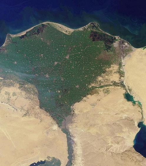
The Nile Delta as seen from Earth orbit. Photo courtesy of
NASA and taken from Wikipedia here. |
def. Delta:
1. The fourth letter of the Greek alphabet (uppercase Δ, lowercase δ).
2. A popular US airline with questionable service (except for those delicious little snacks they serve with your drink), often-delayed flights, and a hilarious in-flight safety video.
3. A triangle-shaped deposit of sediment that forms where a river or stream flows into an ocean, lake, or other large, standing body of water.
Deltas are beautiful landforms, especially when viewed from above. Roughly triangular in shape, deltas are full of complex, wonderful detail: swirling, multi-colored sediments broken by serpentine, miniature river channels. Composed of soft sediment and other alluvium, deltas are shapeshifters: depositing, drifting, building up here, washing away there. Deltas form and evolve at the mercy of both river (or stream) and ocean (or other large, standing body of water). They change with the seasons and with the years, based on waterflow and tides and weather and– in recent years– human influences, such as dams and levees. Deltas are almost chimera landforms: ephemeral, constantly changing. Despite the shapeshifting, many deltas remain in the same location– more-or-less– for millennia, building up thick, rich sediment deposits that are generally good places to live and grow food and which are also greatly valued by geologists trying to understand past climate conditions and ancient river-flow.
 |
| A delta in Bangaladesh. Image courtesy of Peter Clift. |
 |
| Ganges River Delta. Image courtesy of Peter Clift. |
Deltas form when faster-moving, channeled water in a river or stream meets a standing (or still) body of water such as an ocean or lake. Fast-moving waters are able to carry a significant amount of sediment with them as they travel. However, slower-moving waters carry less sediment, and in still waters most sediment will drop out, falling to the bottom of the body of water. Certainly, even still bodies of water such as oceans and lakes contain some sediment. However, they are able to hold much less sediment than a fast (or even slow) moving river or stream. When a river or stream enters a standing body of water, the water spreads out and the velocity of the water drops, along with the carrying capacity of that water for sediment. The large amounts of sediment that drop out because of the velocity change form the soft delta.
Often, deltas have a roughly triangular shape– hence the name. The Greek historian Herodotus (484 BC – 425 BC) noticed that the sediments deposited at the mouth of the Nile River in Egypt formed a roughly triangular shape, like the Greek letter delta. So, Herodotus starting calling the mouth of the Nile a delta [1].
According to the Oxford English Dictionary, the word “delta” was first used in English to describe the Nile River in 1555 and was used as a broader term for the sedimentary feature starting in the late 1700s [2].
However, not all deltas are triangular in shape. Many deltas are roughly triangular because rivers slow down and fan out– often branching into smaller streams amidst the delta sediments– when they reach a standing body of water. However, the shape of a delta really depends on various depositional and erosional forces, including the river but also including forces such as waves and tides [1]. Where river forces dominate, the sediments are more aggressively deposited, and the delta extends out into the standing body of water as a lobe or long arm. Where tidal erosion is significant, deltas tend to be very smaller and cut off sharply at the shoreline. Where wave action dominates, deltas tend to have smooth, arc shapes. There are other factors that influence delta shape as well. For example, along the ocean, large deltas can really only form in places where there are broad continental shelves to support them. If there is a steep drop-off close to where a river meets the ocean, it will be more difficult for sediments to build up into a large delta. And, as I mentioned, deltas are also shapeshifters– if any of the depositional or erosional features change over time, a delta may change shape. Sometimes, if the river moves on, a delta may disappear altogether, partly washed away, often buried and preserved as a thick sedimentary layer in the geologic record.
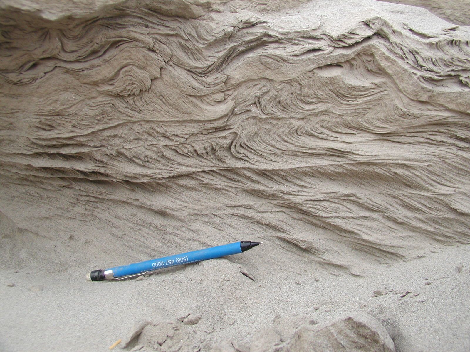
While deltas are perhaps most impressive when viewed from above, they can also be intriguing up-close. Below are some field pictures from my friend Peter Clift, who works in deltas all over the world. These photos are from some work Peter did in the Indus Delta in Pakistan.
 |
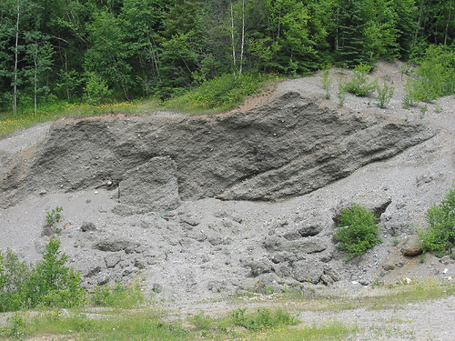
| Soft sediment deformation. Photo courtesy of Peter Clift. |
 |
| Chani Dora boats. Photo courtesy of Peter Clift. |
 |
| Khobar fishing boats. Photo courtesy of Peter Clift. |
Here are a few more pictures of deltas from geobloggers Ron Schott and Brian Romans:
 |
| Delta deposits in Ontario. Photo courtesy of Ron Schott. |
 |
Braided river and delta in Washington State.
Photo courtesy of Brian Romans. |
 |
| Glacial outwash delta in Svalbard, Norway. Photo courtesy of Brian Romans. |
 |
A closer look at the glacial outwash delta. Svalbard, Norway.
Photo courtesy of Brian Romans. |
 |
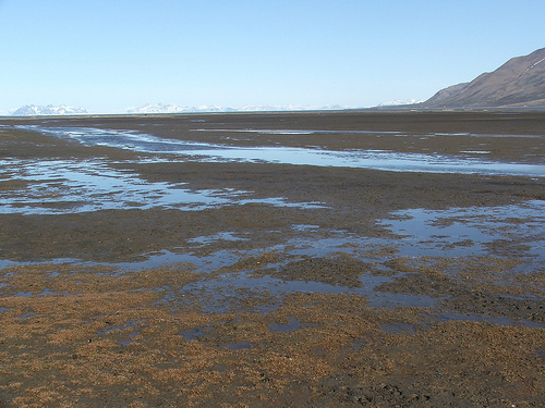
| Tidally-influenced delta in Svalbard, Norway. Photo courtesy of Brian Romans. |
References:
1. Prothero, Donald and Schwab, Fred. 2004. Sedimentary Geology: An Introduction to Sedimentary Rocks and Stratigraphy (Second Edition). New York: W. H. Freeman and Co.
2. “delta, n.” The Oxford English Dictionary. 2nd ed. 1989. OED Online. Oxford University Press. 23 June 2011 .