I’ve been meaning for months to post some pictures from the LASI V Field Trip that I participated in just over a year ago in November 2012. However, despite my best intentions, I never ended up posting some field trip pictures. This is primarily because I lost all of my own LASI V field trip pictures when my laptop and a hard drive were stolen from my apartment back in April. I was quite upset about this and have now diligently backed up all of my computer data online as well as on multiple hard drives. Fortunately, my fellow field trip participants Ben Manton and Stephanie Scheiber were kind enough to send me some of their pictures to share with you here on Georneys.
In the interest of wrapping up a few things here on Georneys before the end of the year, I thought I’d (finally!) share some pictures from the LASI V field trip. You can find my previous posts about LASI V here. A good introductory post about LASI V is here. In brief, the LASI V workshop was a gathering of geologists from around the world to discuss the geology of subvolcanic systems such as sills, dykes, and laccoliths. The field trip went to several places in South Africa’s Karoo region to look at large dolerite sills, hydrothermal vent complexes, and other subvolcanic features which have intruded into various sedimentary units.
Without futher ado, here are some pictures from the LASI V field trip:
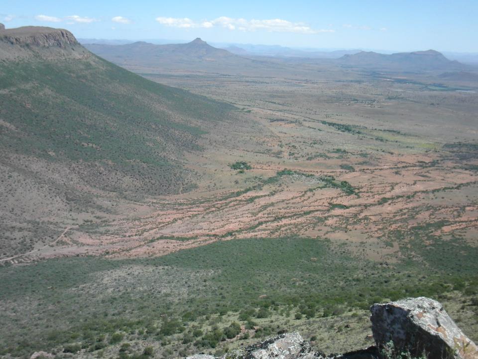
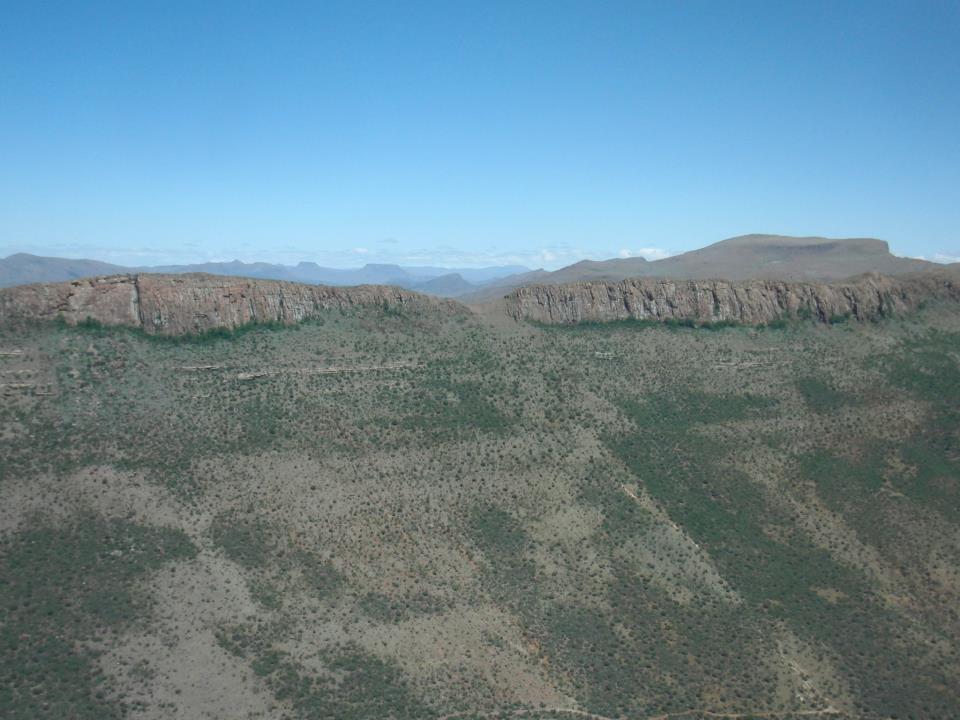
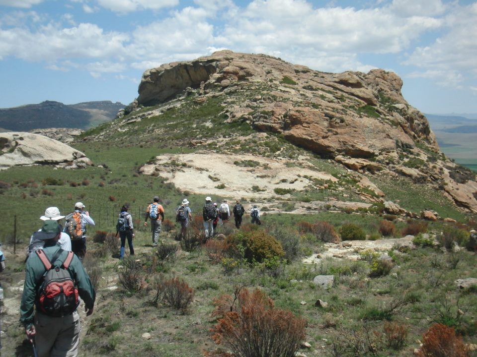
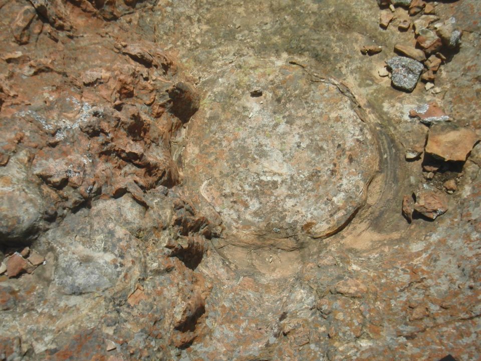
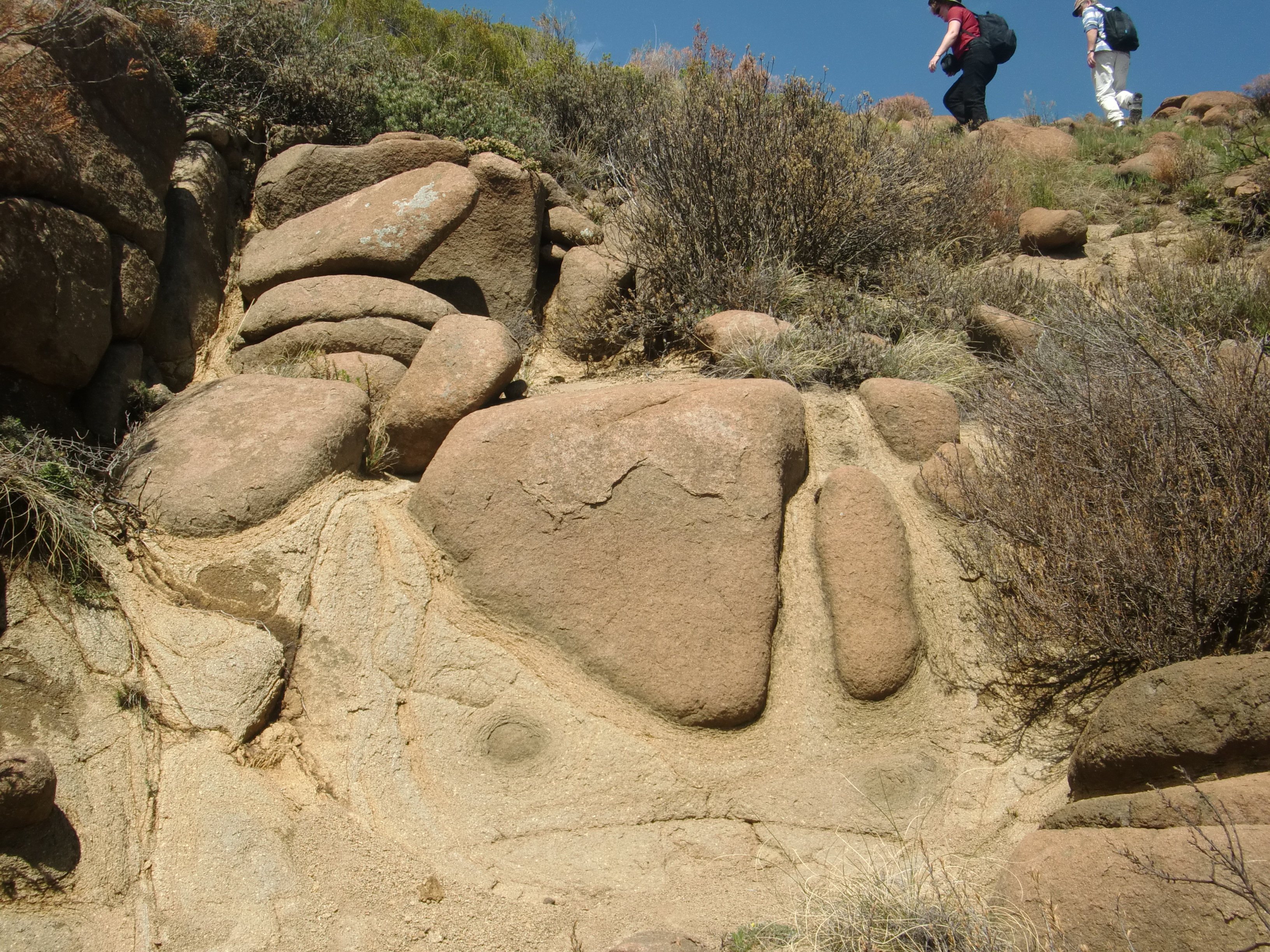
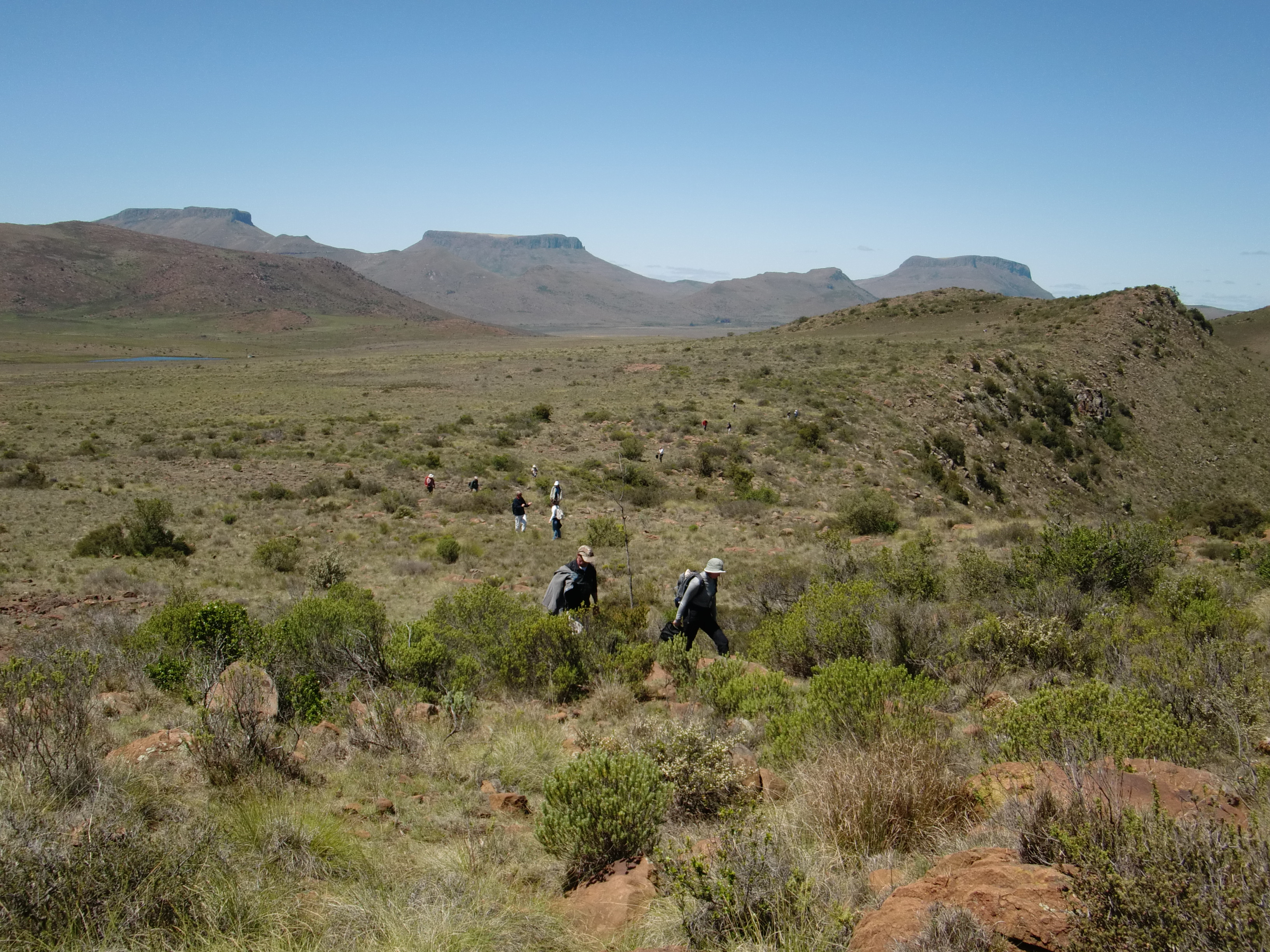
Dolerite sills on top of a hill, with termite mounds in the foreground. Picture courtesy of Ben Manton.The view from the top of a dolerite sill in the Golden Valley region. Picture courtesy of Ben Manton.Impressive dolerite sills in Golden Valley. Picture courtesy of Ben Manton.A beautiful view in the Karoo. Picture courtesy of Ben Manton.Whitkop, a hydrothermal vent feature. Whitkop means “white head” or “white little hill”. Picture courtesy of Ben Manton.Fluid flow features on Whitkop. Picture courtesy of Ben Manton.Circular pipe structures on Whitkop. Picture courtesy of Ben Manton.Checking out some geology (spherical weathering, among other things) on a steep slope. Picture courtesy of Ben Manton.Another beautiful view in the Karoo. Picture courtesy of Ben Manton.Impressive spheroidal weathering of a dolerite sill. Picture courtesy of Stephanie Scheiber.More spheroidal weathering. Picture courtesy of Stephanie Scheiber.Dwyka tillite, one of my favorite rocks! Picture courtesy of Stephanie Scheiber.Another view of Dwyka tillite. Picture courtesy of Stephanie Scheiber.A hydrothermal vent complex… with cows. There are many. many cows and sheep in the Karoo! Picture courtesy of Stephanie Scheiber.A windmill and termite mounds in the foreground, dolerite sills in the background. Picture courtesy of Stephanie Scheiber.Geologists amongst the dolerite sills. Picture courtesy of Stephanie Scheiber.
Note: Dr. Olivier Galland, a senior researcher at the Physics of Geological Processes Center of Excellence at the University of Oslo, presented a talk, “Ground deformation associated with shallow magma intrusions” at the LASI V conference in Port Elizabeth, South Africa in October 2012. The article below is based on this talk and also an interview with Dr. Galland. Over a few weeks, I am highlighting some of the research that was presented at the LASI V workshop. This is the fourth post in that series.
The landscape around an active volcano is dynamic: as magma moves about, the ground may change shape, inflating or deflating depending on how the magma is moving (Steps 1-2 of Fig. 1). The deformation may be caused either by the deep movement of magma or by the shallow intrusion of magma as sills or dykes. The movement can be dramatic (hundreds of meters) or it can be barely noticeable (a few millimeters). Big or small, ground deformation at volcanoes is important to monitor as it can provide clues to what is going on under the surface and, importantly, about when and where a volcanic eruption might occur.
At many volcanoes, geologists monitor ground deformation using a variety of techniques, including physical devices such as GPS and tiltometers, remote sensing techniques such as InSAR, and photogrammetry, which is the analysis of photographic images (Step 3 of Fig. 1). From surface measurements of ground movements, geologists can try to model what is going on underneath the surface (Step 4 of Fig. 1). However, linking observations of surface deformation to magma movements is no easy task (Step 5 of Fig. 1). That’s because geologists cannot generally directly observe the insides of a volcano. An analogy might be trying to understand why a kitchen sink is broken—why it is leaking or not flowing, perhaps— without being able to open up the cabinet door and look at the sink’s plumbing. Geologists can observe ancient volcanic plumbing, so to speak, in places where the tops of volcanoes have eroded away. However, observing the plumbing of active volcanoes is very difficult to impossible. Therefore, geologists generally rely on fancy computer models to try to link surface deformation with subsurface magma movement.
Fig. 1. Schematic diagram illustrating the principle of ground deformation analyses on active volcanoes. Numbering gives the succession of the stages of the analyses. 1. Magma intrudes in volcano, feeding magma reservoir or forming a sheet intrusion (dark gray intrusion). 2. Magma intrusion triggers ground deformation at surface, leading to modified topography (dashed line). 3. Topography variation is measured by geodetic techniques (GPS, InSAR, Photogrammetry, etc.). 4. Geodetic data are compared with modelling of ground deformation due to various intrusion shapes. 5. The best fit between models and ground deformation data provides a calculated intrusion shape (light gray dashed intrusion) responsible for the measured ground deformation. Nevertheless, the calculated intrusion shape is not a unique solution, and no direct observation is available to validate the calculation results.
Computer models are extremely helpful in trying to understand the insides of active volcanoes. However, they do have their limitations. This is because the shapes of magma chambers and shallow magma intrusions can be complex. Computer models can easily accommodate simple shapes such as circles or flat bodies. However, they have a harder time simulating more complex shapes, such as cones or saucers. Computer models also have trouble taking into account all environmental factors, such as the various stress fields and the realistic behavior of rocks. Finally, it is difficult to be completely confident in the results of computer models since the results of such models cannot generally be compared with direct observations.
One way to try to bridge the gap between surface observations of ground deformation and subsurface movements of magma inferred through computer models is through laboratory experiments. Dr. Olivier Galland is one scientist who conducts such experiments. Dr. Galland describes his experimental set-up (Fig. 2a) as, “Actually, it’s very simple. It’s just a box filled with silica flour, which is a fine-grained, granular material that is simulating the brittle crust. And into that material I inject a vegetable oil, which represents the magma, and the pressure of that oil is monitored. And then it’s possible to simulate the transport of magma and the formation of dykes and sills in this box.” Although such procedure seems simplistic, robust dimensional analysis of the method shows that the experimental results at the lab scale are valid at the geological scale.
Fig. 2. a. Drawing of the experimental apparatus. b. Representative oblique view photograph of the model surface during an experiment. The surface exhibited a smooth relief, at the rim of which the oil erupted. Dashed white line locates the section in the next image. c. Representative oblique view photograph of the model after the end of the experiment. The oil solidified and the intrusion was excavated, such that its top surface can be observed. The section showed that the intrusion was a thin sheet, resulting from hydraulic fracturing. Thus, the top surface of the intrusion was representative of its whole shape.
In a recent experiment (Galland, 2012) Dr. Galland used this silica flour and vegetable oil set up to simulate three types of shallow magmatic intrusions: a cone sheet, a dyke connected to a cone sheet, and a saucer-shaped sill. The motivation for this experiment was to provide additional data about the deformation that occurs when these shallow magmatic bodies are emplaced and, in addition, the deformation that occurs when they breach the surface and erupt. While the silica flour and vegetable oil set-up can’t simulate everything about a real volcano, it can provide plenty of important information, especially about the shapes of various intrusions and the pressures of the magma which produces these intrusions. This is possible because the oil is solid at room temperature, such that the final intrusion can be excavated out of the silica flour and its 3D shape analyzed (Fig. 2c).
Dr. Galland explains, “When a volcano is about to erupt or as it is erupted it either inflates or deflates, and this movement can be monitored. And then afterwards this movement is analyzed and inverted by geophysicists who try to calculate the geometry of the magma conduits. The problem is that we can never test these modeling results because we don’t see the intrusions because they are buried. The only way to really test these inversion techniques is to have a system where you measure the deformation and also know the shape of the intrusion and the pressure into the intrusion. And this is what we are doing in our experiments. We can quantify the shape of the intrusion and measure the pressure into the intrusion and measure the surface deformation, and then we can use this dataset to help test the inversion tools used by the geophysicists.”
Already, Dr. Galland’s experimental work is providing some interesting clues as to what is going on under the surface at volcanoes. “Recently, we figured out that there is clearly a link between how magma rises towards the surface and the pattern of the deformation at the surface,” Dr. Galland says. “Interestingly, this pattern develops very early during the experiments in the very early stages. So, we can observe some asymmetric development of this pattern which indicates where the magma is rising. So, if we can analyze that in real time, we could theoretically use it to predict where an eruption will occur. Obviously, in terms of volcanic hazard that is very important.” This is illustrated in the Figure 3, which shows the good match between the shape of the intrusion with the resulting ground deformation.
Fig. 3. Correlation between the shape of the ground deformation and the underlying intrusion in a characteristic experiment. a. Topographic map of model surface before the eruption of the oil. b. Plots of the temporal evolution of topographic profiles across the ground deformation pattern. The profiles are located on the map described in a. Each curve of the plots represents a transient stage of the model surfaces during each experiment. One can notice an initial symmetrical ground deformation, evolving to asymmetrical. c. Topographic map of the top surface of the excavated intrusion. The grey scale indicates the depth in mm below the initial surface. The locations of topographic profiles are the same as on the map of model surface in a, such that the profiles of the ground deformation and of the intrusions can be compared. d. Plots of topographic profiles of the model surface (top) and the underlying intrusion (down) parallel to the X-axis (X-profile). e. Plots of topographic profiles of the model surface (top) and the underlying intrusion (down) parallel to the Y-axis (Y-profile). Notice the vertical scale dilation for the profiles of the model surface. The correlation between e and d show that the ground deformation pattern reflects the shape of the underlying intrusion. This suggests that the asymmetrical development of the ground deformation pattern can be analysed to predict where the magma rises towards the surface.
However, Dr. Galland doesn’t spend all of his time in the laboratory. He believes that it is important for him to regularly go into the field to directly observe volcanoes, modern and ancient. He is particularly interested in observing subvolcanic systems, such as the saucer-shaped sills exposed in South Africa’s Karoo region and intrusive complexes formed in compressional settings exposed in the Neuquén Basin in the north Patagonian Andes. Dr. Galland explains, “My approach is to go to the field and really observe and do some detailed work and then out of that comes a question and then these questions can be subsequently addressed with experiments.” After all, that field knowledge is important for turning silica flour into the Earth’s crust and vegetable oil into magma.
Reference:
Galland, O. 2012. Experimental modelling of ground deformation associated with shallow magma intrusions. Earth and Planetary Science Letters, Vol. 317-318: 145-156.
***Note: Thanks very much to Dr. Galland for providing the three figures and captions.***
Brown and black products of Quaternary glaciovolcanic activity, with Paleozoic granite in the background, northern Victoria Land Antarctica. John Smellie for scale. Photo Credit: National Antarctic Research Program of Italy.
Note: Dr. Sergio Rocchi, an associate professor at the University of Pisa in Italy, presented a talk, “Intravolcanic sills, lava flows, and lava-fed deltas (Victoria Land, Antarctica): Paleoenvironmental Significance” at the LASI V workshop in Port Elizabeth, South Africa in October 2012. The article below is based on this talk and also an interview with Dr. Rocchi. Over a few weeks, I am highlighting some of the research that was presented at the LASI V workshop. This is the third post in that series.
When volcanoes erupt underneath and in the vicinity of glaciers and ice sheets, a unique geological record is created that provides information about both the volcanism and the snow and ice which interacted with the lava as it was being erupted. “Glaciovolcanism” is the term used to describe the interaction of lava with ice, snow (in all its forms, such as “firn” or compacted snow), and meltwater.
Glaciovolcanism includes study of modern examples in places such as Iceland and Antarctica as well as study of ancient examples. For the ancient examples, the ice and snow have generally long since melted away as a result of changing climate over the ages. Furthermore, the sediments and sedimentary rocks—tills and moraines and diamicts— associated with the glaciers and ice sheets have also often long since eroded away. However, volcanic rocks which interacted with the ice and snow are harder and slower to erode, and they often remain long after ice and sediment have disappeared.
Dissected late Pliocene volcano, northern Victoria Land Antarctica. John Smellie for scale. Photo Credit: National Antarctic Research Program of Italy.
Glaciovolcanic rocks can provide much valuable information about ancient glaciers and ice sheets. For example, study of glaciovolcanic rocks can help geologists identify if ice was present and, if so, can help geologists learn about the thickness of the ice, the elevation where the ice was present, the temperature conditions at the base of the ice, and the structure of the ice. A limitation is that volcanic eruptions do not occur continuously. Depending on the circumstances, they may occur at intervals of 10s—or even of 100s or 1000s— of years. Also, over time even hard glaciovolcanic rocks can erode away. Nevertheless, study of glaciovolcanic rocks is a powerful tool for reconstructing past ice cover and conditions, which in turn provides much information about past climate that can complement other paleoclimate studies—for example, study of sedimentary and coral records. Volcanic rocks are also fairly easy to date using isotopic techniques, so they can provide clear age constraints to help with paleoclimatic reconstructions.
Dr. Sergio Rocchi is a volcanologist who has studied glaciovolcanic rocks in Antarctica along with his colleague Dr. John Smellie and other co-workers. Dr. Rocchi explains, “Volcanic eruptions in subglacial environments generate some glacial volcanic lithofacies [units of rocks with certain characteristics] which can tell us the thickness and also the type of ice that was present at the time of the eruption. Additionally, the volcanic rocks can be dated by isotopic means, so the combination of the age and thickness of the ice can be a very useful source of paleoenvironmental information.”
Sergio Rocchi flying over Mt Melbourne Volcano, northern Victoria Land Antarctica. Photo credit: National Antarctic Research Program of Italy.Sergio Rocchi over Campbell Glacier, northern Victoria Land Antarctica. Photo credit: National Antarctic Research Program of Italy.
As an example, Dr. Rocchi and his co-workers have studied Late Miocene glaciovolcanic rocks of Victoria Land, Antarctica. There, hyaloclastite-rich glaciovolcanic rocks, including some “lava-fed deltas” (features which form when lava enters water either in a marine/lacustrine or a glacial meltwater environment), have enabled reconstruction of Late Miocene glacial cover over Victoria Land. The glaciovolcanic rocks indicate that at this time Victoria Land was covered by a thin (<300 m thick) cover of ice. This ice sheet is much thinner than that predicted by some modeling studies and implies a more complex climatic transition in the Miocene than previously thought.
While most work regarding glaciovolcanism to date has been carried out in Antarctica, study of glaciovolcanism can also be done in many other places. “Similar work can obviously been done wherever there are or were volcanoes and ice,” says Dr. Rocchi. “The main places where volcano-ice interaction can be studied are Antarctica, Iceland, and British Columbia in the northern Cascades. A future project for which we are raising funding is making a comparison of the glaciovolcanic record in Antarctica with that in Iceland.”
In the future, study of glaciovolcanism will no doubt continue to help geologists and climate scientists unravel the history and nature of past glaciers and ice sheets. Combined with other paleoclimate records, study of glaciovolcanism will help scientists to better understand how Earth’s climate used to be and how climate changes over time. This information is invaluable in a time when humans are experiencing the effects of anthropogenic climate change and when scientists need as much information as possible in order to evaluate what may happen to Earth’s climate in the coming years.
Smellie, J., Wilch, T., and Rocchi, S., 2013. ‘A‘ā lava-fed deltas: A new reference tool in paleoenvironmental studies. Geology. (to be published in the April issue).
Smellie, J., Rocchi, S., and Armienti, P. 2011. Late Miocene volcanic sequences in northern Victoria Land, Antarctica: products of glaciovolcanic eruptions under different thermal regimes. Bulletin of Volcanology, Vol. 73: 1-25.
Smellie, J., Rocchi, S., Gemelli, M., Di Vincenzo, G., and Armienti, P. 2011. A thin predominantly cold-based Late Miocene East Antarctic ice sheet inferred from glaciovolcanic sequences in northern Victoria Land, Antarctica. Palaeogeography, Palaeoclimatology, Palaeoecology, Vol. 307: 129-149.
Smellie, J., Johnson, J., McIntosh, W., Esser, R., Gudmundsson, M., Hambrey, M., van Wyk de Vries, B. 2008. Six million years of glacial history recorded in volcanic lithofacies of the James Ross Island Volcanic Group, Antarctica Peninsula. Palaeogeography, Palaeoclimatology, Palaeoecology, Vol. 260: 122-148.
Back in late October and early November 2012, I attended the LASI V Workshop on the “physical volcanology of subvolcanic systems: laccoliths, sills, and dykes” as an observer and science writer. The workshop started out with 2 days of talks at the Pine Lodge Conference Centre in Port Elizabeth, South Africa. Recently, I have been writing about some of the research that was presented during these talks. I’ve already written about Dr. Volcano in the Cave of Crystals, Naica, Mexico and Xeno-Pumice: Mysterious Floating Rocks of the Canary Islands, and there’s more coming soon! However, I thought I should also start sharing some information about the wonderful LASI V field trip, especially since some of the research presented during the talks was about the remarkable subvolcanic systems that can be observed in South Africa’s Karoo Basin.
Today, I just want to give a quick introduction to the field trip route and the locations visited. In my next field trip post, I’ll give a general overview of Karoo Basin geology. Then, I’ll share some information and plenty of pictures from the various LASI V field trip stops. We visited so much great geology that I might not have time to cover everything, but I’ll do my best!
The LASI V field trip lasted 3 days. The map below shows the main locations visited during the field trip.
Field Trip Stops during the LASI V workshop. Image taken from the field trip guide.
Here are the places that we visited during the field trip:
Day 1: We drove from Port Elizabeth to Aloe Grove, which is located just outside of Queenstown. On the way, we visited outcrops of Dwyka tillite and Ecca Group deep to shallow marine sediments. We also visited Elandsberg Mountain, where dolerite sills have been intruded into fluvial sandstones of the Beaufort Group. While we were at Elandsberg, we spent quite a bit of time looking at a dolerite sill with impressive spheroidal weathering. Finally, we visited Waterdown Dam, where there are some remarkable granophyre dykes that were produced by the interaction of dolerites and sedimentary rocks.
Day 2: We spent all day exploring the saucer-shaped sill complexes in the Golden Valley.
Day 3: We visited a place known as Witkop III, a hydrothermal vent complex.
That’s all for now. More about the field trip soon!
More geology posts about the LASI V workshop are coming, but meanwhile here’s another biological interlude. One day during the Karoo field trip, we spotted a dung beetle. Dung beetles are pretty neat little critters, actually. And they can move balls of dung remarkably quickly!
A dung beetle in South Africa's Karoo region, November 2012.Another view of the dung beetle and its dung ball, November 2012.
Note: Dr. Steffi Burchardt, a senior lecturer in Structural Geology at Uppsala University in Sweden, presented a talk, “Xeno-pumice erupted offshore El Hierro, Canary Islands: A tale of stoped blocks in magma chambers?” at the LASI V workshop in Port Elizabeth, South Africa in October 2012. The article below is based on this talk and also an interview with Dr. Burchardt. Over a few weeks, I am highlighting some of the research that was presented at the LASI V workshop. This is the second post in that series.
Following a period of intense seismic activity, on October 10th, 2011 a submarine eruption began approximately 1 kilometer off the coast of El Hierro, the youngest and westernmost island in the Canary Islands, which is a group of volcanic islands believed to have been formed through hotspot volcanism. The eruption was evident from the unusual conditions on the sea surface: the sea bubbled, like a Jacuzzi, and was stained green. The large green stain was easily observable from space. In the midst of these strange conditions, some highly unusual rocks were erupted. For several days after the sea started bubbling, strange floating rocks were observed and collected off the coast of La Restinga, the closest town to the undersea eruption. These floating stones were generally tens of centimeters in size and resembled lava bombs in shape. The outsides of these floating rocks consisted of basanite , a rock type commonly observed in the Canary Islands and other volcanic ocean islands. Basanites don’t generally float. However, these basanite shells floated because their insides were filled with a white to light grey, pumice-like material. Pumice is a highly vesicular rock, which means that it is a rock full of voids or bubbles, which make the rock light enough to float on water.
Figure showing the green stain on the sea during the early days of the 2011 El Hierro eruption. Figure from Troll et al., 2012.A restingolite bomb with a basanite crust and a white, pumice-like interior. Photo courtesy of Dr. Steffi Burchardt.
While the pumice-like centers explained why the rocks floated, they also raised a multitude of questions and triggered some heated debates amongst geologists. This is because pumice is not commonly produced in the Canary Islands* or in other oceanic island hotspot environments, such as Hawaii and Iceland. The lavas erupted at oceanic island hotspots are generally mafic, low viscosity lavas such as basalts (and basanites). Viscosity is, in essence, a measure of how resistant lava is to flowing. The less viscous a lava, the more likely that lava is to flow. Therefore, low viscosity lavas such as basalts tend to flow easily and also tend to regularly release volatiles such as water and carbon dioxide. Therefore, the pressures in these lavas remain relatively low, and violent eruptions are uncommon. Pumice is most commonly produced during eruptions of felsic, highly viscous, volatile-rich lavas, which are found in environments such as island arcs, not oceanic island hotspots. The voids or bubbles in pumice represent places where volatiles have been rapidly released due to a pressure change, often during a violent eruption.
So, what was pumice-like material doing in an oceanic island eruption? A number of theories were put forward to try to explain the floating rocks that were erupted off of La Restinga. Some scientists thought the pumice-like material represented juvenile, highly silicic, highly viscous magma (such as rhyolite), which is very explosive. Other scientists proposed that the pumice-like material represented re-melted magmatic material, altered volcanic rock, or reheated hyaloclastite or zeolite from the slopes of El Hierro. Mysterious in origin, the floating stones were called “restingolites” after the nearby town of La Restinga.
After extensive analysis, a group of scientists (Troll et al., 2012) proposed an alternative hypothesis to explain the pumice-like material found in the restingolites. Based on the material’s high silica content, lack of igneous trace element signatures, and high oxygen isotope values as well as the presence of remnant quartz, jasper, carbonate, and wollastonite, Troll et al. concluded that the pumice-like material in the restingolites in fact represented xenolithic material from pre-island sedimentary layers that were picked up and heated by ascending magma, which caused the layers to partially melt and bubble. Looking like pumice and originating as xenoliths, Troll et al. dubbed the restingolites “xeno-pumice”.
Dr. Burchardt elaborates, “Xeno-pumice is definitely not an established term. We have coined it for the first time in the case of El Hierro eruption. The name comes from adding the preface ‘xeno-‘, which means foreign, to ‘pumice’. We used this term because the floating rocks of El Hierro present the characteristics of pumice, but they are actually not pumice in origin; they are actually xenoliths. We found out, based on mineralogy and also the fact that they contain detrital sand grains and fossils, that they are actually not magmatic in origin but rather that they are xenoliths from the sedimentary layers that underlay the Canary Islands. So, they are older than the volcanism. When the magma was rising, it stagnated at this level and interacted with the sedimentary rocks, sandstone and minor carbonate, and the magmas transported the xenoliths up with them to the ocean floor, where they were erupted. But in the process of the ascent of these xenoliths, they were subject to heat from the magma, so they started to melt. Since they contain a lot of water, this water started to boil and formed bubbles. The end product was something that looked like a pumice: lots of bubbles surrounded by a glassy matrix.”
Schematic from Troll et al. 2012 illustrating how the El Hierro restingolites may have formed.
Even though xeno-pumice was not a known rock type before the 2011 El Hierro eruption, Dr. Burchardt and her colleagues think that xeno-pumice may actually be a common—if not commonly recognized—rock type in other parts of the world.
Dr. Burchardt explains, “The El Hierro eruption was a very fortuitous circumstance for our work because my colleagues and I had been working on similar rocks from volcanoes worldwide, but that they were not previously recognized as xeno-pumice. The El Hierro eruption was therefore some kind of a breakthrough for our research in this field, and there will be a whole series of papers dealing with xeno-pumice from different parts of the world.”
By November, the xeno-pumice rocks were no longer being erupted, and worries that a dangerous, explosive eruption could occur at El Hierro abated. The identification of the restingolites as xeno-pumice was also good news for the hazard risk at El Hierro.
Dr. Burchardt explains, “It was good news that these xenoliths are sedimentary in origin because it means that there is no rhyolitic magma beneath the island, which means that a big explosive eruption isn’t likely.”
While the xeno-pumice rocks do not carry the message that an explosive eruption is likely to occur at El Hierro, they do carry other important messages from the deep. The unusual xeno-pumice rocks observed erupting at El Hierro in 2011 can provide much direct information about the interaction of magma and oceanic sediments and also may indicate that recycling of oceanic sediments into magma is an important process at ocean islands. Further study of xeno-pumice from the Canary Islands—and also from other parts of the world—will go a long way towards helping geologists better understand how volcanic eruptions at ocean islands interact with oceanic crust and sediments as they make their way to the surface.
*Update: Commentor Siim Sepp points out that intermediate composition pumice is found on the Canary Islands, most notably on the island of Tenerife. This is a very good point. I have perhaps oversimplified the explanation– pumice can be found at volcanic ocean islands under certain conditions. Thanks for pointing this out, Siim!
Reference:
Troll, V.R., Klügel, A., Longpré, M.-A., Burchardt, S., Deegan, F. M., Carracedo, J. C., Wiesmaier, S., Kuepper, U., Dahren, B., Blythe, L. S., Hansteen, T., Freda, C., Budd, D., Jolis, E. M., Jonsson, E., Meade, F. C., Harris, C., Berg, S. E., Macini, L., Polacci, M., and Pedroza, K. 2012. Floating stones off El Hierro, Canary Islands: xenoliths of pre-island sedimentary origin in the early products of the October 2011 eruption. Solid Earth, Vol. 3: 97-110.
Note: Dr. Dougal Jerram—aka “Dr. Volcano”— presented a talk, “When Shallow Intrusions Make Silver Mines—A Journey into Superman’s Cave, Naica, Mexico” at the LASI V workshop in Port Elizabeth, South Africa in October 2012. The article below is based on this talk and also an interview with Dr. Volcano. Over the next few weeks, I will be highlighting some of the research that was presented at the LASI V workshop. This is the first post in that series.
The title of this blog post, “Dr. Volcano in the Cave of Crystals”, may sound like the title of a comic book or a science fiction story, but I can assure you that both Dr. Volcano and the Cave of Crystals are very much real. I had the pleasure of meeting Dr. Volcano and hearing about his visit to the Cave of Crystals at the LASI V workshop back in October 2012.
Dr. Volcano is also known as Dr. Dougal Jerram, who in June 2011 left his academic position at Durham University to set up DougalEARTH Ltd. and embark on an exciting new career as an independent geological consultant, researcher, and also a media consultant, becoming involved in science outreach and popular science entertainment. On his website DougalEARTH, Dr. Jerram states that he is, “aiming to make science more accessible to the general public and promoting our understanding of the planet.” In his science outreach and media work, Dr. Jerram is known as “Dr. Volcano.” The title is certainly appropriate since he has published dozens of scientific research articles about volcanoes and has also penned two books about volcanoes, The Field Description of Igneous Rocks (with Nick Petford, 2011) and Introducing Volcanology: A Guide to Hot Rocks (also 2011). For his scientific outreach and media work, Dr. Volcano has appeared on television programs for stations such as the BBC, The History Channel, and National Geographic.
The Channel 9 News Team in the Cave of Crystals. Picture courtesy of Andy Taylor.
As part of his media work, Dr. Volcano had the extraordinary opportunity to visit a place in Naica, Mexico known as Cueva de los Cristales or the Cave of Crystals (http://en.wikipedia.org/wiki/Cave_of_the_Crystals) in the Fall of 2011. Dr. Volcano visited the cave as part of a news team for a 60 Minutes documentary for Channel 9 News, Australia. The cave is also known as the Giant Crystal Cave and Superman’s Cave, since it resembles the Arctic home of the comic book character Superman. Located about 1000 feet (about 300 meters) below the Earth’s surface, the cave contains gigantic crystals of selenite (gypsum, CaSO4•2H2O) that are some of the largest known crystals on Earth. The largest crystals in the cave are nearly 40 feet (12 meters) tall!
The Cave of Crystals was first discovered in 2000 by miners who were excavating a new tunnel for the silver, zinc, and lead mine owned by the Industrias Peñoles mining company. Previously, a similar cave known as Cueva de las Espadas or the Cave of Swords was discovered in 1910. This cave is also located at Naica but at a shallower depth of about 400 feet (about 120 meters). However, the selenite crystals in the Cave of Swords are smaller, with a maximum size of about 6 feet (2 meters). In addition, many of the crystals from the Cave of Swords have been removed from the cave and transported to other places, such as museums.
A map of the Naica mine showing the locations of the Cave of Swords and the Cave of Crystals. Figure taken from Garcia-Ruiz et al. (2007).
Dr. Volcano explains, “We had the very lucky opportunity to go into the Naica caves in Mexico. These caves are very special because they have—arguably—the largest crystals on the planet. These crystals are gypsum, which is calcium sulphate (dihydrate). We were able to get into these caves after two years of negotiation with the Mexican mine and the government there.”
Prior to mining, the Cave of Crystals was underwater. The cave is only exposed because the mining company has pumped water away, lowering the groundwater level so that mining can proceed deeper. Naturally, the groundwater level is about -110 meters. Once pumping stops, the Cave of Crystals will again fill with groundwater. And not just any groundwater. The cave will fill with very hot groundwater since the Earth is quite warm at 300 meters depth. Research (e.g. Ruiz-Garcia et al., 2007) suggests that the enormous selenite crystals found in the Cave of Crystals likely formed in low-salinity fluids that were at a temperature of approximately 54 degrees Celsius. The selenite crystals grew very slowly over hundreds of thousands of years, enabling the crystals to reach their enormous sizes.
While no longer filled with hot fluid, the Cave of Crystals nevertheless remains an inhospitable environment for humans. Temperatures in the cave are 45 to 50 degrees Celsius, and the humidity ranges from 90 to 100%. While the mining shafts are cooled for the workers, the Cave of Crystals is not cooled, which helps preserve the giant selenite crystals. Visiting the Cave of Crystals is therefore no easy feat.
Dr. Volcano describes, “You go inside the cave, and you’re in temperatures of around 50 degrees Celsius, and the humidity is around 100%. One of the biggest problems when you go into an environment like that is that your body is unable to cope with that environment, and you effectively start dying the minute you enter the cave.”
In such an extreme environment, humans can only survive unaided for a few minutes.
Dr. Volcano elaborates, “The biggest problem you have is that when your body temperature is the lowest temperature in the cave, everything that your body does to try to cool itself doesn’t work. It tries to sweat, but the sweat doesn’t evaporate because there’s 100% humidity, so there’s no cooling from evaporation. You breathe in air, but the air is hotter than your internal body, so it starts heating up your body. You start to pant, like a dog, which is a natural reaction to try to cool yourself, but as a result you end up heating the interior of your body more quickly. We found that after 9 minutes in the cave without any sort of protection, our body temperatures rose to 39.5 degrees Celsius, which is quite dangerous. We had an Australian medic with us (David Rosengren), and he said that if your body temperature goes over 40 degrees Celsius, you could very rapidly deteriorate and even die.”
Fortunately, the Channel 9 news team came prepared.
Dr. Volcano explains, “We had a kind of solution, which we called ‘Formula 1 Geology.’ We used the same sort of suit that people in extreme sports, such as Formula 1 racing, use in environments where they can get very hot very quickly. It’s a close-to-the-body suit with piping inside that pumps cold water around the body. You wear a backpack with ice water, and an electric pump moves that cold water around the suit. With the suit, we could safely stay in the cave for about 25-30 minutes. Ultimately, if other people could refill the backpacks with more ice cold water, people could possibly stay in the cave much longer.”
As difficult as it is for humans to explore the Cave of Crystals at present, if mining ever stops at the Naica mine then it may become impossible to visit the cave since it will again fill with hot fluid.
Dr. Volcano wonders, “The giant crystal caves are only exposed because man is pumping the groundwater out. The biggest dilemma that we have for this natural wonder of the earth is: if the mining stops, then in principle the water level will rise again, and the Naica caves will be underwater again. I pose to the general public: what should be done—if anything—to save the Naica caves?”
I wonder that, too. It may be that the unique and remarkable Cave of Crystals will only be accessible for a brief time, only as long as the Naica mine remains in business.
So, I’ve been meaning to put up another LASI V post or two, but I’ve been extremely busy with my day job over the past few weeks. I hope to have another substantive LASI V post up soon, but in the meantime here’s a lovely biological interlude post that contains pictures of some vegetation which I observed during the LASI V field trip to South Africa’s Karoo. As I geologist, I generally dislike vegetation since it covers up all the pretty rocks. Sometimes, though, vegetation is pretty enough that I don’t mind it too much. If any botanists read this post and know about the vegetation in the pictures, please enlighten us geologists!
Observed on Day #1 of the LASI V Field Trip:
A lovely cactus of some sort.Pretty pink biology thingies.A closer view of one of the pretty pink biology thingies.
Observed on Day #2 of the LASI V Field Trip:
Another cactus... with some sills in the background!Very interesting vegetation growing on a rock.A closer view of the rock-covering vegetation, with a 2 Rand coin for scale (about the size of an American nickel).
Observed on Day #3 of the LASI V Field Trip:
Trees and some grass on a farm in the Karoo.A closer view of the grass.Pretty purple flowers.Yellow flowers... and some rocks in the background. A spiky cactus. Don't want to step on this one!The view from the top of a place called "Witkop 3". I'll be writing all about Witkop 3, so stay tuned!A zoom-in of the view down in the valley below Witkop 3. Flowers and sheep!Little yellow flowers.More little yellow flowers.
For the LASI V workshop which I attended a couple of weeks ago, the Physics of Geological Processes (a scientific Center of Excellence in Norway and one of the workshop sponsors) offered two scholarships for South African geology students to attend the workshop. I thought I would introduce you to the two wonderful scholarship awardees here on Georneys. Both of the scholarship awardees are studying for their masters degrees in geology with Prof. Gary Stevens at Stellenbosch University, which is one of the top universities in South Africa. Both students presented their masters degree projects at the conference.
Priscilla in the field at LASI V.
The first scholarship awardee is Priscilla Ramphaka, who comes from the Limpopo Province of South Africa. At LASI V Priscilla presented a talk titled, “The origin of rhythmic magmatic layering in the S-type Peninsula Pluton, Cape Granite Suite, South Africa.”
Prsicilla explains, “I presented my project on the layering in the granites found at Llandudno in Cape Town. My goal was to find out how the layering formed at Llandundo since that is not well understood.”
Priscilla says that she loved everything about the LASI V workshop, from the presentations to the field trip to the meeting of new people. Overall, she says that she really enjoyed participating in her first international geology conference. In addition to being a talented geologist, Priscilla is also a talented linguist– she speaks an impressive 10 languages!
Cedric in the field at LASI V.
The second scholarship awardee is Cedric Joseph, who comes from Windhoek, Namibia. At LASI V Cedric presented a talk titled, “The petrogenesis of the ignimbrites and quartz porphyritic granites exposed along the Saldhana west coast, South Africa.”
Cedric explains, “I did a project on the ignimbrites and subvolcanic rocks that you find around Saldhana. We investigated the petrogenesis of the rocks as well as the rock textures because it’s quite a controversial issue whether these rocks are intrusive or extrusive.”
Cedric says that his favorite part of the LASI V workshop was learning more about sills and dykes, particularly through observing these features in the field. Cedric is looking forward to working for a mining company in Namibia starting next year.
I really enjoyed meeting both Priscilla and Cedric at LASI V. I hope to run into them again, especially since Stellenbosch is just down the road from where I live in Cape Town.