Geology Word of the Week: E is for Eclogite

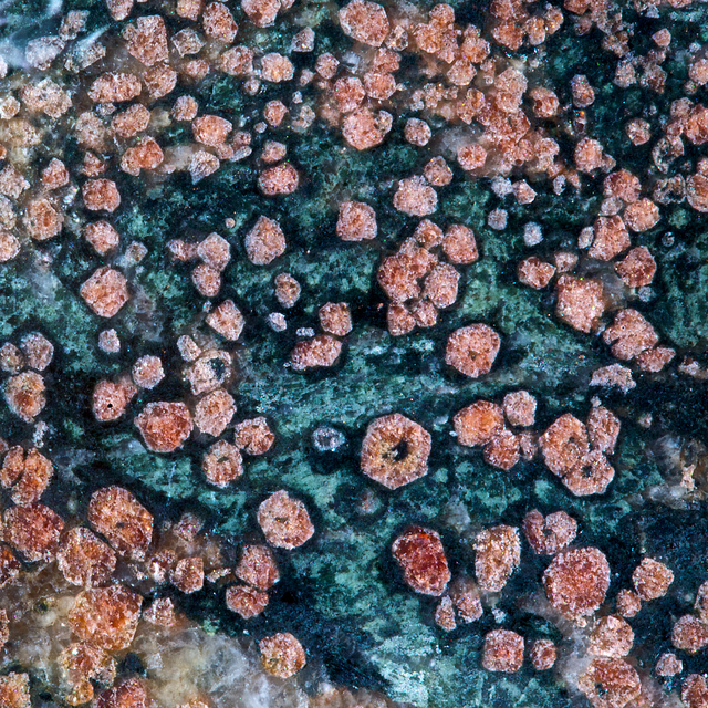
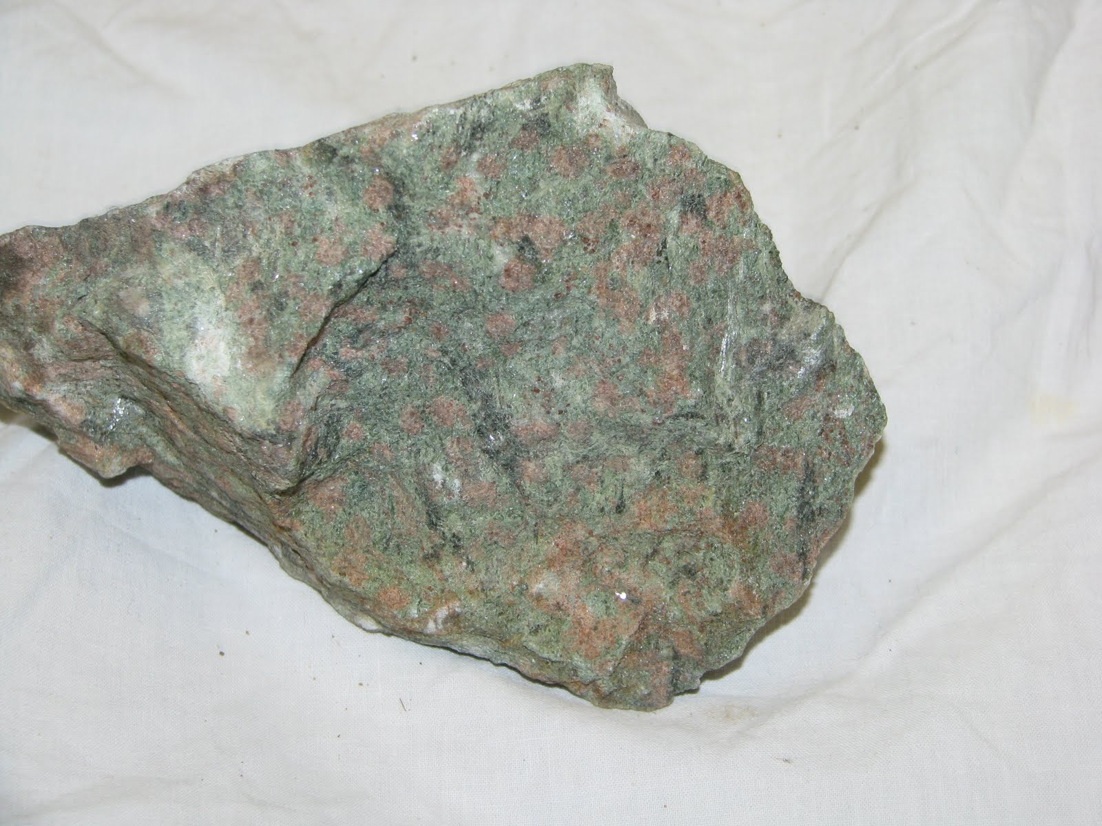
Eclogite from the Mariánské Lázně Complex in the west Czech Republic.
Keele collection. Check out those gorgeous pink garnets!
Photo courtesy of Ian Stimpson.

def. Eclogite:
A high-pressure, high-temperature, coarse-grained metamorphic rock consisting primarily of pink-red garnet (almadine-pyrope variety) and green pyroxene (omphacite, a sodium-rich variety). Eclogites may also contain small amounts of other high-pressure minerals such as kyanite, quartz, hornblende, and zoisite. Eclogites form when mafic rock (basalt or gabbro) descends deep within the Earth, generally at a subduction zone. Mafic rocks consist primarily of pyroxene and plagioclase (along with some amphibole and olivine). At high pressures and temperatures, the original minerals in mafic rock are squished into the more compact (denser) minerals garnet and omphacite, and the mafic rock becomes eclogite. Eclogites form when mafic rock encounters temperatures greater than ~400 degrees Celsius and pressures greater than ~12 kbar (or ~1.2 GPa). These temperatures and pressures mean that eclogites form at a minimum depth of ~40 km; some eclogites may form as deep as ~150 km. As a reference, ocean crust (which is comprised primarily of basalt and gabbro) is generally only 6-10 km thick. Because they are very dense and inclined to descend even deeper into Earth’s mantle, eclogites are rarely brought to Earth’s surface. Eclogites may be exposed in ophiolite sequences and other places where deep mantle rocks are brought to Earth’s surface. Often, eclogites experience partial or full retrograde metamorphism as they are brought to Earth’s surface. That is, if eclogites are brought to the surface slowly, their minerals may change back into minerals that are stable at lower temperatures and pressures. Sometimes, higher-pressure minerals will have rims of lower-pressure minerals around them.

Eclogites are stunningly beautiful red-green rocks that represent what happens to black basalt and green gabbro when these crustal rocks descend deep into Earth’s mantle. Basalt, gabbro, and eclogite have identical chemical compositions. That is, if you crushed these three rocks and measured the proportion of different elements (for example, calcium, silicon, and iron) in these rocks, you would find that the chemical proportions of elements in these three rocks are nearly identical. However, these rocks look very different. Basalt is generally black or gray and fine-grained, meaning that the mineral crystals are very small, often too small to see with the naked eye. Sometimes, basalt may contain a few isolated, large crystals of a particular mineral, often plagioclase picked up from a magma chamber. Gabbro contains the same minerals as basalt, but because gabbro forms deeper in the crust, the mineral crystals are larger because the rock cooled more slowly, giving large crystals time to grow. Eclogite has the same chemistry as basalt and gabbro but has different minerals. Basically, the minerals in eclogite are squished (denser) forms of the minerals found in basalt and gabbro.

Basalt boulder in a garden in Madiera, Portugal.
Photo courtesy of Ian Stimpson.

A gabbro from the Bushveld Complex, Central Transvaal, South Africa. Keele
collection. The white mineral is plagioclase and the green-black mineral is pyroxene.
Photo Courtesy of Ian Stimpson.

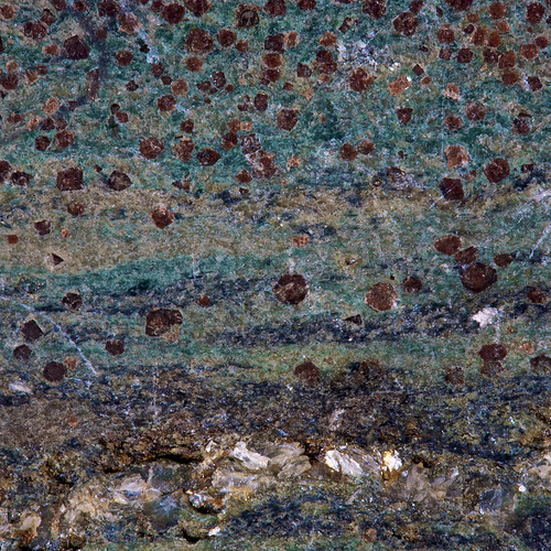
An eclogite from the lawsonite type locality, Reed Station on the Tiburon Peninsula,
Marin County, California. Keele collection. Photo courtesy of Ian Stimpson.

Eclogite is a very interesting rock. Aside from being an absolutely gorgeous rock, eclogite is intriguing because it provides direct evidence that basalt and gabbro descend deep within the Earth. For a long time, geologists thought that perhaps a significant portion of Earth’s mantle was composed of eclogite and that melting of this eclogite might produce basalts and gabbros at or near Earth’s surface. Now, geologists understand that most of Earth’s mantle is composed of a rock called peridotite, which consists primarily of pyroxene and olivine. Geologists also now understand that rocks rarely melt 100%. So, partial melting of peridotite to produce basalt and gabbro makes much more sense than melting of eclogite to produce these rocks. You see, to produce a basalt or gabbro from an eclogite, you would have to melt that eclogite close to 100%, which just isn’t feasible on our Earth. However, eclogites still play a role in mantle melting processes (eclogite melts may mix with peridotite melts, for instance), and melting of eclogites can produce other crustal rocks, such as the somewhat unusual and weird-sounding rocks adakite and trondhjemite.

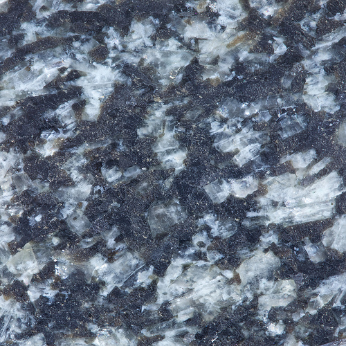
A Scottish eclogite from the Lewisian inlier, Glen Beag, Glenelg.
Keele collection. Photo courtesy of Ian Stimpson.

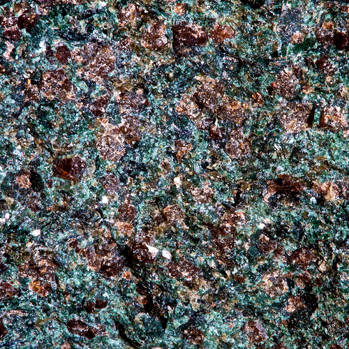
An eclogite from Lago Mucrone, Santuario Di Oropo, Italy.
Keele Collection. Photo courtesy of Ian Stimpson.

Eclogite from Adula Nappe, The Alps. Photo courtesy of Ron Schott.

Here is a GigaPan (a really neat picture which you can zoom in on) of an eclogite-blueschist facies mixed rock from California (GigaPan courtesy of Ron Schott):

When you look at the eclogite pictures in this post, just think: eclogites are rocks that used to be common basalts or gabbros, which then descended to incredibly great depths within the Earth, then returned to Earth’s surface against all odds. Study of eclogite rocks provides important information about what happens to ocean crust after it plunges into a subduction zone and thus provides insight into very deep mantle processes. What remarkable rocks!

Metamorphic facies. Figure taken from Wikipedia Commons here. Click to view larger.

Eclogite is also the name of one of the metamorphic facies. A metamorphic facies is a region of pressure-temperature space in which characteristic metamorphic minerals form. Most eclogite facies are eclogites– that is, they are basalts or gabbros which have experienced metamorphism at eclogite facies pressures and temperatures. However, sometimes other rock types (notably, granodiorites and pelites) may experience eclogite facies metamorphism, but these rocks are not proper eclogites, just eclogite facies rocks.

***Thanks so much to Ian Stimpson (and his incredible Flickr rock photo set!) and Ron Schott for photos for this week’s geology word post.***

Accretionary Wedge #35: Favorite Geology Words

As many of you know, I hosted the Accretionary Wedge Geoblog Carnival for June, and I asked What’s Your Favorite Geology Word? Turns out, many of you have favorite geology words! Geologists– like many scientists, I suppose– are fond of their jargon. Personally, I’m so fond of jargon that I blog about a geology word every week. I love many geology words, but if I had to pick an absolute favorite, it’s ophiolite.

Thanks so much to everyone who participated and shared a favorite geology word! The words are listed below, in the order in which they were posted. If I somehow missed your word, please let me know in the comments, and I’ll add it.

Jazinator of The Geology P.A.G.E. likes the Icelandic word jökulhlaup.

Reynardo of Musings of the Midnight Fox wrote a wonderful poem about the word volcano.

The Short Geologist of Accidental Remediation says that varves are not flashy, but they sure are pretty!

Ryan of Glacial Till says that he loves many geology words, but that welded tuff has to be one of his favorite geology phrases.

Jessica of Magma Cum Laude thinks autobrecciation is a really cool process– and she explains it very well, too!

Callan of Mountain Beltway is fond of the word boudinage, especially when said with “a heavy French accent and a leering, dirty expression.” 

Ian of Hypo-theses thinks crozzle has a great sound to it. I agree! What a fun word– almost sounds like a Dr. Suess word or maybe a something that a Jaberwocky might encounter. 

Denise of Life as a Geologist likes the word mylonite (or Míléngyáng in Chinese). She shares a beautiful Chinese poem with us and also some pictures of mylonites from Hong Kong.

Dana of En Tequila es Verdad seduced us with subduction.

David of History of Geology really likes geology, in several languages!

Shockingly, Chris of Highly Allochthonous likes the word allochthonous. His co-blogger Ann also likes the word allochthonous but for different reasons.

I swear that Brian of Clastic Detritus made up the word geophantasmogram. But I love the word anyway! I think Brian wins the internet (at least the geology part of the internet) with this word.

Jefferson of Anisotropic Reflections likes the folded rocks that hang out in an anticlinorium.

Elli of Life in Plane Light tells a wonderful story about how she first learned the word disthen.

Suvrat of Rapid Uplift came up with a word I cannot pronounce: primarrumf. I’m going to go ahead and pronounce the word “pirate’s rump” like Suvrat’s friend.

Silver Fox of Looking for Detachment tells us why she likes detachment. Also, she says everyone should become friends with Detachment Fault on Facebook.

Ron of the Geology Home Companion Blog had a little trouble settling on a favorite word but finally went for Tavurvur.

Mika of GeoMika thinks that rheology is an ugly word for a pretty science, but I disagree. I think rheology is a very pretty word. Rhea is also one of my favorite girls’ names!

Andrew of About Geology wrote about palinspastic. Interestingly, this was the very first geology word I blogged about during my previous (failed) attempts to keep up with the geology word of the week on Skepchick, a skeptical blogging group which I have recently left.

Simon writes about why he likes the word porphyroblast over at Earth Science Erratics.

Chuck of Lounge of the Lab Lemming is fond of the word sphene but not of that horrible “T-word.”

John of Geologic Musings in the Taconic Mountains also likes the word jökulhlaup.

Selim of GeoSelim explains why he likes the word isopach.

A Life-Long Scholar really likes mountains and the word orogenesis.

Julia of Stages of Succession cheated and picked two words: bioturbation and turbidite. It’s okay, Julia. I can’t really decide what my favorite geology word is, so I blog about one every week.

G of Gioscience also likes mountains, I assume, with a favorite word of orogeny. Did you hear that time that Antarctica Africa, and South America were caught in a three-way orogeny? Shocking, I tell you!

MyPhyz likes (in the comments) the word unconformity.

MK of Research at a Snail’s Pace is also fond of bioturbaton.

Tannis of Tannis Likes Rocks is fascinated by geohistory.

Finally, Jacquelyn starts a new blog called The Contemplative Mammoth with a post about playing with gyttja mud.

Thanks again to all the participants! If you have other favorite geology words, post them in the comments!

Geology Word of the Week: D is for Delta

The Nile Delta as seen from Earth orbit. Photo courtesy of
NASA and taken from Wikipedia here.

def. Delta:
1. The fourth letter of the Greek alphabet (uppercase Δ, lowercase δ).
2. A popular US airline with questionable service (except for those delicious little snacks they serve with your drink), often-delayed flights, and a hilarious in-flight safety video
3. A triangle-shaped deposit of sediment that forms where a river or stream flows into an ocean, lake, or other large, standing body of water.

Deltas are beautiful landforms, especially when viewed from above. Roughly triangular in shape, deltas are full of complex, wonderful detail: swirling, multi-colored sediments broken by serpentine, miniature river channels. Composed of soft sediment and other alluvium, deltas are shapeshifters: depositing, drifting, building up here, washing away there. Deltas form and evolve at the mercy of both river (or stream) and ocean (or other large, standing body of water). They change with the seasons and with the years, based on waterflow and tides and weather and– in recent years– human influences, such as dams and levees. Deltas are almost chimera landforms: ephemeral, constantly changing. Despite the shapeshifting, many deltas remain in the same location– more-or-less– for millennia, building up thick, rich sediment deposits that are generally good places to live and grow food and which are also greatly valued by geologists trying to understand past climate conditions and ancient river-flow.

A delta in Bangaladesh. Image courtesy of Peter Clift.
Ganges River Delta. Image courtesy of Peter Clift.

Deltas form when faster-moving, channeled water in a river or stream meets a standing (or still) body of water such as an ocean or lake. Fast-moving waters are able to carry a significant amount of sediment with them as they travel. However, slower-moving waters carry less sediment, and in still waters most sediment will drop out, falling to the bottom of the body of water. Certainly, even still bodies of water such as oceans and lakes contain some sediment. However, they are able to hold much less sediment than a fast (or even slow) moving river or stream. When a river or stream enters a standing body of water, the water spreads out and the velocity of the water drops, along with the carrying capacity of that water for sediment. The large amounts of sediment that drop out because of the velocity change form the soft delta.

Often, deltas have a roughly triangular shape– hence the name. The Greek historian Herodotus (484 BC – 425 BC) noticed that the sediments deposited at the mouth of the Nile River in Egypt formed a roughly triangular shape, like the Greek letter delta. So, Herodotus starting calling the mouth of the Nile a delta [1].
According to the Oxford English Dictionary, the word “delta” was first used in English to describe the Nile River in 1555 and was used as a broader term for the sedimentary feature starting in the late 1700s [2].

However, not all deltas are triangular in shape. Many deltas are roughly triangular because rivers slow down and fan out– often branching into smaller streams amidst the delta sediments– when they reach a standing body of water. However, the shape of a delta really depends on various depositional and erosional forces, including the river but also including forces such as waves and tides [1]. Where river forces dominate, the sediments are more aggressively deposited, and the delta extends out into the standing body of water as a lobe or long arm. Where tidal erosion is significant, deltas tend to be very smaller and cut off sharply at the shoreline.  Where wave action dominates, deltas tend to have smooth, arc shapes. There are other factors that influence delta shape as well. For example, along the ocean, large deltas can really only form in places where there are broad continental shelves to support them. If there is a steep drop-off close to where a river meets the ocean, it will be more difficult for sediments to build up into a large delta. And, as I mentioned, deltas are also shapeshifters– if any of the depositional or erosional features change over time, a delta may change shape. Sometimes, if the river moves on, a delta may disappear altogether, partly washed away, often buried and preserved as a thick sedimentary layer in the geologic record.

While deltas are perhaps most impressive when viewed from above, they can also be intriguing up-close. Below are some field pictures from my friend Peter Clift, who works in deltas all over the world. These photos are from some work Peter did in the Indus Delta in Pakistan.

Soft sediment deformation. Photo courtesy of Peter Clift.
Chani Dora boats. Photo courtesy of Peter Clift.
Khobar fishing boats. Photo courtesy of Peter Clift.

Here are a few more pictures of deltas from geobloggers Ron Schott and Brian Romans:

Delta deposits in Ontario. Photo courtesy of Ron Schott.
Braided river and delta in Washington State.
Photo courtesy of Brian Romans.
Glacial outwash delta in Svalbard, Norway. Photo courtesy of Brian Romans.
A closer look at the glacial outwash delta. Svalbard, Norway.
Photo courtesy of Brian Romans.
Tidally-influenced delta in Svalbard, Norway. Photo courtesy of Brian Romans.

References:

1. Prothero, Donald and Schwab, Fred. 2004. Sedimentary Geology: An Introduction to Sedimentary Rocks and Stratigraphy (Second Edition). New York: W. H. Freeman and Co. 

2. “delta, n.” The Oxford English Dictionary. 2nd ed. 1989. OED Online. Oxford University Press. 23 June 2011  .

Geology Word of the Week: C is for Coquina

Coquina rock. Image taken from wikipedia here.

def. Coquina (“co-keen-ah”):
A sedimentary rock consisting of loosely-consolidated fragments of shells and/or coral. The matrix or “cement” consolidating the fragments is generally calcium carbonate or phosphate. Coquina is a soft, white rock which is often used as a building stone. Coquina forms in near-shore environments, such as marine reefs. According to the Oxford English Dictionary, coquina is a loanword from Spanish meaning “shell-fish” or “cockle” (a type of bivalve mollusc). Also according to the Oxford English Dictionary, the word was first used in English (to refer to the building stone) in 1837 in the book The Territory of Florida by J.L. Williams.

I remember exactly when I first learned the word “coquina.” When I was in high school, I had the opportunity to take some science electives in addition to the normal biology, chemistry, and physics courses. One of the electives I took was geology. I remember reading the textbook for the class (I believe it was Essentials of Geology), and there was a picture of coquina rock in the chapter on sedimentary rocks. I remember thinking, “Cool!” when I saw the picture of coquina. To me, coquina was a great rock because it was so simple: the rock was clearly composed of shell and coral fragments which had been cemented together. The fragments were large and obvious and just barely cemented together.  I think I liked coquina so much because I was a bit overwhelmed by all of the rock and mineral types when I took that first high school geology class.  I loved learning about rocks and minerals, but I found myself somewhat befuddled by all of the names and strategies used for identification. I had to think before I could confidently distinguish amphibole from pyroxene or diorite from dolerite. Coquina, on the other hand, was a refreshingly simple rock to identify.

While relatively simple to identify, coquina can actually be a complex rock. There are many different types of shell and coral fragments that can cement together to form coquina. Identification of these fragments is important in order to fully classify and understand the origin of a particular coquina, but this identification can sometimes be challenging. Like with any sedimentary rock, the origin of a particular fragment in coquina may sometimes be mysterious. Coquina may also be covered in mud and dirt or weathered, making identification difficult at first glance. Many coquina rocks were formed recently (within the past few thousand years), but some coquina rocks are older. Determining the age of older coquina is sometimes important for understanding local geology. For instance, since coquina forms in a near-shore environment, determining ages of coquina deposits (either marine or on land) can help reconstruct sea level rise and fall over time. However, determining the ages of sedimentary rocks, including coquina, is always a challenge since diverse fragments (often of different ages) have come together to form new rock.

Below is a picture some coquina that was collected from the seafloor just off the coast of southern Africa by my fiance, who is also a geologist. My fiance regularly finds coquina and shell fragments in the marine sedimentary rocks he studies. He is sometimes able to date coquina and other shell-containing sedimentary rocks by identification of shells.  Since certain shell-making organisms lived at specific times in the past, identification of some types of shells can be used to date coquina rocks. Coquina rocks can also sometimes be dated by their location within a sequence of sedimentary rocks. For instance, if the ages of rock layers on either side of a coquina layer are of a known age, then the age of  the coquina layer can be bracketed.

My fiance writes about this particular coquina,

Here is a picture of the coquina rocks – bear in mind these were photographed right after being collected off the sea-bed so are still covered in bits of mud. The entire “rock” consists of shell cemented by calcareous material and phosphorite. The sample contains least two different species of shell: a thin, long, spirally shell and a clam-like shell. From my seismic work I’ve interpreted this unit as Miocene in age (Burdigalian ~ 20 million years old).

Coquina collected at sea off the coast of Southern Africa.
Photo courtesy of Jackie Gauntlett.

Coquina is commonly used as a building stone, particularly in places (such as Florida and the West Indies) with large coquina deposits. Coquina is a very soft building material, so soft that it needs to be dried out  in the sun for a few years before being used as a building stone. Apparently, the softness of coquina made it an ideal building stone for some forts. For example, coquina was used to build the Castillo de San Marcos Fort in St. Augustine, Florida. The fort was built by the Spanish in the late 1600s when Florida was a Spanish territory. When British forces attacked the fort in 1702 during the Siege of St. Augustine, they fired cannon balls at the fort. However, the cannons were not effective at destroying the fort because the cannonballs kept sinking into the soft coquina. Forts are normally made out of harder stone, which fractures or punctures when hit with cannonballs.

Since the British could not break through the coquina walls, they were forced to lay siege to the fort. Eventually, Spanish relief ships forced the British to withdraw. The British managed to burn down much of the St. Augustine fort as they retreated (not sure why they didn’t try that earlier, honestly), but the fort was rebuilt and refurbished by the Spanish a few years later. However, the British did not give up, returning for a second siege and eventually taking over the fort in 1763. Just think, though… that pesky soft coquina kept the British from taking over the fort for 61 years.

Castillo de San Marcos fort. Image taken from wikipedia here.

In addition to being a good cannonball protector, coquina is a beautiful ornamental building stone. In response to my request on twitter (@GeoEvelyn) for coquina pictures, Phoebe Cohen (@PhoebeFossil) sent me some beautiful coquina pictures which she took just a couple of days ago in Shark Bay, Australia. The building where she is currently staying is made out of gorgeous coquina that was mined locally.

Phoebe writes,

This building at Carbla Station, Western Australia, is made entirely of blocks of coquina. The coquina comes from the nearby beach of Shark Bay, a hyper-saline semi-restricted area. The coquina forms right near the beach, mainly from tiny clam shells washed up onshore. The shells are compressed and turned into a cohesive mass as rain water filters through them, dissolving a little bit of the shell’s calcium carbonate, which then glues the shells together. The coquina here is no longer used for building stone, as it is now in a protected marine park area.

Here are Phoebe’s pictures of the coquina building:

Coquina building in Shark Bay, Australia. Photo courtesy of Phoebe Cohen.

A closer look at the coquina building stones, Shark Bay, Australia.
Photo courtesy of Phoebe Cohen.

An even closer look at a coquina building stone in Shark Bay, Australia.
Photo courtesy of Phoebe Cohen.

And here’s a picture from Phoebe of an old coquina mining site:

Old coquina mining location, Carbla Beach, Shark Bay, Australia.
Photo courtesy of Phoebe Cohen.

Geology Word of the Week: B is for Brunton

Brunton “Pocket Transit” Compass. Image taken from here.

def. Brunton:
A fancy, highly-precise compass used by geologists (and surveyors, engineers, archaeologists, etc.) for navigation and also to measure the strike and dip of rock layers in the field.

Since I am waiting to board a flight to Wyoming, I thought it would be appropriate for this week’s geology word to be “Brunton.” Brunton compasses are made by the Brunton Company of Riverton, Wyoming. The first Brunton compass was made by David W. Brunton in 1894. Since then, the Brunton compass (often shortened to just “Brunton”) has become standard field equipment for the geologist. Today, the Brunton company makes a variety of compasses and navigational devices. Their “Pocket Transit” compass is the most common compass used by geologists. Personally, I own a Conventional Brunton Pocket Transit as well as a stand-alone Brunton inclinometer called the Clinomaster. Brunton compasses aren’t cheap (the Pocket Transit is about $500), but a Brunton is an important investment for the field geologist.

Geologists use Bruntons for general navigation (like a regular compass, the Brunton has a needle that points to magnetic north) as well as to measure the strike and dip of rock layers. Using a Brunton can be a little intimidating at first, but geology students generally learn all about the Brunton at field camp. After a few days of practice, measuring strikes and dips of rock layers using a Brunton becomes second-nature. Geologists use these strike and dip measurements to make geologic maps. Strike and dip measurements are also useful for understanding the geologic structure and history (e.g. uplift and deformation) of a region. Bruntons can also be used (along with camera lens covers, pencils, field notebooks, hammers, etc.) to provide a sense of scale in pictures of rocks.

Here is a website that teaches you how to use a Brunton to measure strike and dip:
MIT Website on Using a Brunton Compass

Figure showing strike and dip of rock layers. Figure taken from here.

Below are a few pictures of Bruntons in the field. Feel free to add more pictures of you with your own Brunton. Either put a link in the comments or email me the pictures, and I’ll add them to this post.

Bruntons can be mystifying at first to geology field camp students. The Stretch
(Dartmouth College’s geology field camp), Western USA, Fall 2005.
Using a Brunton inclinometer to measure a far-off mountainslope angle. A
regular Brunton rests on the rock to show me the direction I am looking,
Oman, January 2009.
Collecting a rock sample with Brunton safely stored in its leather carrying
pouch (at my waist), Oman, January 2009.

Geology Word of the Week: A is for Accretionary Wedge

Illustration of a convergent plate boundary. I’ve added a red arrow pointing out the
location of the accretionary wedge. Illustration from TASA graphics and taken from here.
Click to view larger.

def. Accretionary Wedge (aka Accretionary Prism, Subduction Complex):
A wedge- or prism-shaped mass of sediments and rock fragments which has accumulated where a downgoing oceanic plate meets an overriding plate (either oceanic or continental) at a subduction zone. The sediment is generally marine sediment that has been scraped off of the downgoing plate by the overriding plate. However, sediment from the overriding plate can also contribute to the accretionary wedge. Fragments of rock from the colliding tectonic plates can also accumulate in an accretionary wedge.  The sedimentary rocks which form at accretionary wedges are deformed, faulted, poorly-sorted mixtures which are often referred to as “melange” (which means “mixture” in French).

Since I’m hosting this month’s Accretionary Wedge Geoblog Carnival and I’m at the letter A in my second geologist’s alphabet, I thought it would be fitting for “accretionary wedge” to be featured as this week’s geology word (phrase) of the week.

An accretionary wedge is basically a hodge-podge collection of various sediments and rocks, scraped up and squished together where two tectonic plates collide and one plate subducts underneath another. The downgoing plate is always an oceanic plate (continental plates don’t really subduct as continental crust is too buoyant), but the overriding plate can be either another oceanic plate (such as the Japan subduction zone) or a continental plate (such as the Cascades subduction zone). The sediments in an accretionary wedge are mostly marine sediments scraped off of the downgoing oceanic plate. Most of the marine sediments on the oceanic plate actually subduct down into the mantle. However, some of the marine sediments pile up and are accumulated into a wedge or prism-shaped pile of sediments where the downgoing plate meets the overriding plate. This scraped-off marine sediment is mixed with other material such as sediments weathered/transported from the overriding plate and fragments of rock broken off of the colliding tectonic plates.

Because the sediments are primarily scraped off of the downgoing plate, accretionary wedges actually accrete new material primarily on the bottom of the wedge. This means the younger sedimentary rocks in an accretionary wedge are generally on the bottom, which is topsy-turvy to the classic Law of Superposition in geology.

The primary rock type which forms at accretionary wedges is a jumbled, fractured sedimentary rock known as melange. I’m not sure why– I guess French sounds smarter and more scientific?

Geologist Donald Prothero describes melange wonderfully in his textbook Interpreting the Stratigraphic Record:

“The most characteristic rock type of the accretionary wedge is melange (French, “mixture”), a mass of chaotically mixed, brecciated blocks in a highly sheared matrix. This deformation and pervasive shearing and brecciation are due to the tremendous compressional and shear forces generated by the downgoing slab [aka tectonic plate]. Melange is so mixed that it shows no stratigraphic continuity or sequence, and blocks and boulders from everywhere are mixed together. Some are exotic blocks from terranes no longer present in the vicinity.”  

Does anyone have any good pictures of melange rocks? If so, post a link below in a comment or send me the pics by email (see sidebar), and I’ll add them to the post. 

I think that Accretionary Wedge is a great name for a Geoblog Carnival, which is a jumbled mixture of blog posts just as a real accretionary wedge is a jumbled mixture of sediments and rocks.

Reference:
Prothero, Donald. Interpreting the Stratigraphic Record. New York: W.H. Freeman & Company, 1990.

Accretionary Wedge #35: What’s Your Favorite Geology Word?

I’m hosting this month’s Accretionary Wedge Geoblog Carnival here at Georneys. Since I write about a geology word every week (see the “Geology Word of the Week” tag on the sidebar or the post “A Geologist’s Alphabet”), I thought it would be fitting to host an etymological Accretionary Wedge. This month’s Accretionary Wedge is easy– if you want you can post just a single word!

The theme for this month is:

What’s your favorite geology word?

You can post just the word if you want. You can also add anything you want– a definition, some pictures related to the word, a story about the word, a poem, a drawing. Anything at all!

I must warn you, though: if you post about a good word, I may use the word in a future Geology Word of the Week post!

To join the geoblog carnival, just write a post on your blog and then link to it in a comment below or in a comment over at the Accretionary Wedge site. If you don’t have a blog, you should start one. If you don’t want to start a blog, just type your word in a comment below. Please submit your entries by the 26th or thereabouts so that I can compile them by the end of the month. Happy blogging!

Finally, be sure to check out last month’s Accretionary Wedge #34: Weird Geology.

A Geologist’s Alphabet

Every week (except for the month when I interviewed my dad about Fukushima) since I started this blog back in November 2010 I’ve posted a “Geology Word of the Week.” For some reason I decided it would be fun to cycle through the alphabet from A to Z, and I’ve now accomplished that, writing about words from Alluvium to Zanclean.

Perhaps the alphabet theme is cliche, but I’m having fun with it. So, I think I’ll cycle through the alphabet at least one more time. You can expect another A word (Allochthonous? Alvin? Albite? You’ll have to stay tuned!) next week.

Here’s my first geologist’s alphabet:

A is for Alluvium
B is for (Volcanic) Bomb
C is for Coprolite
D is for Dredge
E is for Eustasy
F is for Fabric
G is for Gondwana
H is for Hotspot
I is for Ichnite
J is for Jurassic
K is for Komatiite
L is for Lithosphere
M is for Magma
N is for Nabkha
O is for Ophiolite
P is for Peridot
Q is for Quaternary
R is for Rock
S is for Speleothem
T is for Travertine
U is for Uraninite
V is for Vesicle (and Vug)
W is for Wadi
X is for Xenolith
Y is for Yardang
Z is for Zanclean

Geology Word of the Week: Z is for Zanclean

Geologic Timescale Spiral. Image courtesy of USGS. Taken from Wikipedia here. Click to enlarge.

def. Zanclean:
A geologic Age spanning from ~5.33 million years ago to ~3.60 million years ago in the Pliocene Epoch.

Q: What do the words Zanclean, Burdigalian, and Maastrichtian have in common?
A: They’re all Ages of geologic time! So are the Tithonian, Albian, Sinemurian, Norian, and dozens of others.

Never heard of the Zanclean? Don’t worry. I had never heard of it either before I did a little research for this blog post. I have only memorized the geologic timescale through the Epochs, and then only for the Cenozoic (65 million years ago to present).
The Zanclean is defined as the geologic Age which spans from ~5.33 million years ago to ~3.60 million years ago. You might be thinking to yourself that this is a strange bracket for geologic time. Why not just make the Age an even 5 to 3 million years ago? If you look closely at the geologic timescale you’ll notice that the geologic Ages (as well as the Eons, Eras, Periods, and Epochs… but we’ll get to that in a minute) are all different lengths of time that seem random.

The geologic Ages do span inconsistent lengths of absolute time. This is because Ages such as the Zanclean (which was introduced in 1868, according to Wikipedia) were defined long before absolute dating of rocks became possible after the discovery of radioactivity in the late 1800s and the development of radioactive dating of rocks and minerals in the early to mid 1900s. Scientists have only been able to confidently determine absolute ages for rocks since the 1960s or so, and every year techniques for dating rocks become better with smaller error bars.

Remarkably, geologists defined the entire geologic timescale (although standardizing this timescale internationally is still an ongoing process) prior to the development of absolute dating of rocks and minerals. Although the absolute ages were unknown, geologists were able to work out the time periods based on the evolution of the fossil record. The main divisions of time are based on time periods when certain types of ancient organisms lived.

Boundaries between different periods of geologic time often mark periods of mass extinctions where there was a sudden, dramatic change in the fossil record. The most famous example of this is the boundary between the Tertiary and the Cretaceous, also known as the K-T boundary. This boundary ~65 million years ago is marked by a mass extinction event famously known to have wiped out all non-avian dinosaurs. The boundary is known at the K-T boundary because “K” is used for Cretaceous and “T” is used for Tertiary on geologic maps and other places where shorthand is appropriate. Geologists have known for generations about boundaries such as K-T and about ages such as the Zanclean, but it has only been in the second half of the 1900s that they were able to start assigning absolute ages to these geologic times.

I mentioned above that I had never really heard of the Zanclean before. That’s true– I have never bothered to memorize the geologic Ages, one of the smallest divisions of geologic time, and the smallest one recognized by the International Commission on Stratigraphy or ICS. I don’t think I will ever bother to memorize them as I can easily look them up and, honestly, I think it’s a bit silly to subdivide geologic time into such small sections. Whenever I read papers that bother with naming various Ages, I just keep a copy of the geologic timescale nearby. I have taken the time to memorize the larger divisions of geologic time, which are (from largest to smallest): Eons, Eras, Periods, and Epochs. And, as I mentioned previously, I’ve only memorized the Cenozoic Epochs because they’re the only Epochs with names. Otherwise, it’s just “early,” “middle,” and “late,” and I find these very difficult to memorize.

The way that I originally memorized the Periods and so on was through use of mnemonics. My favorite mnemonic for the geologic Periods is Cold Oysters Seldom Develop Many Precious Pearls, Their Juices Congeal Too Quickly which helps me remember: Cambrian, Ordovician, Silurian, Devonian, Mississippian, Pennsylvanian, Permian, Triassic, Jurassic, Cretaceous, Tertiary, Quaternary. For the Cenozoic Epochs, I like the mnemonic Pigeon Egg Omelets Make People Puke Hourly which helps me remember Paleocene, Eocene, Oligocene, Miocene, Pliocene, Pleistocene, Holocene.

So perhaps what I need to remember the Ages is an appropriate (and very long!) mnemonic. I propose a challenge to my blog readers: come up with a mnemonic for the geologic Ages.

The Ages are: CALABRIAN, GELASIAN, PIACENZIAN, ZANCLEAN, MESSINIAN, TORTONIAN, SERRAVALLIAN, LANGHIAN, BURDIGALIAN, AQUITANIAN, CHATTIAN, RUPELIAN, PRIABONIAN, BARTONIAN, LUTETIAN, YPRESIAN, THANETIAN, SELANDIAN, DANIAN, MAASTRICHTIAN, CAMPANIAN, SANTONIAN, CONIACIAN, TURONIAN, CENOMANIAN, ALBIAN, APTIAN, BARREMIAN, HAUTERIVIAN, VALANGINIAN, BERRIASIAN, TITHONIAN, KIMMERIDGIAN, OXFORDIAN, CALLOVIAN, BATHONIAN, BAJOCIAN, AALENIAN, TOARCIAN, PLIENSBACHIAN, SINEMURIAN, HETTANGIAN, RHAETIAN, NORIAN, CARNIAN, LADINIAN, ANISIAN, OLENEKIAN, INDUAN, CHANGHSINGIAN, WUCHIAPINGIAN, CAPITANIAN, WORDIAN, ROADIAN, KUNGURIAN, ARTINSKIAN, SAKMARIAN, ASSELIAN, GZELIAN, KASIMOVIAN, MOSCOVIAN, BASHKIRIAN, SERPUKHOVIAN, VISEAN, TOURNAISIAN, FAMENNIAN, FRASNIAN, GIVETIAN, EIFELIAN, EMSIAN, PRAGHIAN, LOCKHOVIAN, PRIDOLIAN, LUDFORDIAN, GORSTIAN, HOMERIAN, SHEINWOODIAN, TELYCHIAN, AERONIAN, RHUDDANIAN, HIRNANTIAN, KATIAN, SANDBIAN, DARRIWILIAN, DAPINGIAN, FLOIAN, TREMADOCIAN, STAGE 10, STAGE 9, PAIBIAN, GUZHANGIAN, DRUMIAN, STAGE 5, STAGE 4, STAGE 3, STAGE 2, FORTUNIAN.

Phew! I hope I didn’t miss any of the ages. I apologize that they are all written in capital letters. I’m not yelling at you. I just copied and pasted the names from a geologic timescale, and I’m too lazy to change them out of all capital letters.

So, see if you can come up with a long-winded mneumonic. You know, something like:
Campbell gave pretty, zany, messy, terribly sexy, lovable, bright, amazing, cheerful Rachel praises by letters youthfully, tentatively sent. Did Mister Campbell say convincing truths carefully ascertained about beautiful, hauntingly vividly beautiful, tantalizing, kiss-invoking, outstanding, creative, breathtaking, blushing, all-knowing, terrific, pleasing, scintillating, hot Rachel? No. Courage leaves an overwhelmed, inconsolable Campbell. Why?! Campbell wondered. Rachel knows a summer affair grows kinda muted because summer visions tear, famously fragmenting ephemeral, end-bound, primitive love. Perhaps lust graces hot summer times, announces Rachel. However, keep summer dreams dampered, flowing temporally, staying 10, staying 9, painfully gone days, staying 5, staying 4, staying 3, staying 2, forgotten. 

Please improve upon my rather “film noir”, adjective-filled, and, admittedly, very terrible mneumonic. Though, on second thought, I don’t think this (or any) epic mnemonic is going to be that helpful in memorizing geologic Ages. On third thought, memorizing the geologic Ages is stupid. The only reason I can fathom for memorizing the Ages is to impress geology friends at a bar. Maybe I’ll work on it sometime, but honestly I think it’s only marginally more useful than memorizing digits of pi.

Geology Word of the Week: Y is for Yardang

Yardangs 1. Photo courtesy of Michael Welland.

Cross-posted at Through the Sandglass

def. Yardang (also sometimes: jardang):
An elongated erosional landform, commonly found in deserts, resembling the hull of an inverted boat. Similar to sand dunes, yardangs typically have a tall, steep side facing the prevailing wind direction and slope gently down away from the wind. Yardangs are formed when looser material is eroded away (primarily by the wind and particle abrasion), leaving behind more consolidated material that is then sculpted into strange, ship-like shapes by further erosion. Yardangs most commonly form in soft rocks such as siltstone and sandstone (rocks commonly found in deserts) but can also form in harder rocks in places where the wind is the primary erosional force. The word yardang is of Turkish origin coming from the word “yar” which means “steep bank or precipice.” According to the Oxford English Dictionary, the word yardang was first introduced to the English language in 1904 by the Swedish explorer Sven Anders Hendin.

I had actually never heard of the word “yardang” until quite recently. Earlier this year I wrote to Michael Welland, author of the book Sand: The Never-ending Story and the Through the Sandglass blog, and asked him if he had any pictures of nabkhas for my “N is for Nabkha” word of the week. Michael wrote back promptly and sent me a beautiful picture of some nabkhas in Namibia. He also told me that he had some great yardang pictures for when I reached the letter Y. 

Well, I’ve finally reached the letter Y, and Michael has been kind enough to send me some pictures of yardangs and also some musings on these strange desert landforms. Both the pictures and the musings are below. Thanks so much, Michael!

Yardangs 2. Photo courtesy of Michael Welland.
Yardangs 3. Photo courtesy of Michael Welland. Click to enlarge.
Yardangs 4. Photo Courtesy of Michael Welland. Click to enlarge.

Michael’s Yardang Musings:
In the distance, in the morning desert sun, would seem to be herd of great beasts, grazing on the sand. They are, like all good herds, all facing in the same direction, but barely moving. On closer inspection, they are, of course, not moving at all and are completely inanimate clay and silt – but herd would still seem to be the right collective noun for yardangs. Yardangs. For once, a piece of geo-terminology that seems right, exotic but with a vague and indefinable animate sound to it that suits these things – “a yardang can go for days without water.”

They cluster together in a slight depression in the landscape, in all likelihood an old lake bed in which their clay and siltstone were deposited. The lake dried up as the climate changed, bringing with it the desert, the sand, and the wind. And the sand and the wind conspired as a great sculptor, sand-blasting the softest sediment, liberating the rough forms of the harder rock. The abrasional power of the sand is greatest within a meter or so of the ground, the height of flying grains in a sandstorm limited by the physics that Ralph Bagnold set out. And the sculpting takes place in the face of the prevailing wind, the face of the rock heading into the wind receiving the fiercest blasting, eddies and the slipstream chipping away in its lee. So these things explain some of the forms of the yardangs – the front face undercut to the maximum height of the strongest sandblast, leaving the “head” above. The result is, of course, reminiscent of the Great Sphinx, and romantic speculators like to think of yardangs as the inspiration for the iconic monument. Just as the Sphinx was for so long draped and buried in the sand, so the yardangs  are draped in the debris of their deterioration, and drifts of sand pile up against their flanks. But they are simply the inevitable result of aeolian processes – they are all facing the same way because they are facing into the prevailing wind, their shapes are determined by the interplay between the physics of flying sand and the varying resistance of the rocks that are in its way.
So far, so good – but think about them some more, and yardangs have their mysteries. Why are they spaced out the way they are? Some intrinsic depositional variation in the old lake sediments? Or is there some feedback going on here, one yardang influencing the flow of the wind so as to preclude another one developing within some critical distance? And, while I talked blithely about “eddies and the slipstream” chipping away in the lee of the front face, what does this actually mean? Why is the slope and curve of their “backs” so remarkably uniform?  I don’t know that we know the answers to such questions – which is why there is an intrinsic geo-weirdness to them. But, regardless of any geo-weirdness, a herd of yardangs is simply weird in its own right, making for a distinctly weird landscape.

And you just can’t not think of them as a herd. As we walked away, I could have sworn some of them were watching us.