A quartzite outcrop in Minas Gerais state, Brazil. Picture taken by me in February 2023.
def. Quartzite:
A metamorphic rock that consists primarily of interlocking grains of the mineral quartz. Quartzite forms when quartz-rich sandstone undergoes metamorphism.
The term “quartzite” is an example of a geologic term that can be a little confusing. Most of the time, geologists use the term “quartzite” to refer to a metamorphic rock, which is the definition that I have provided above. Sometimes, geologists also use the term “quartzite” to refer to a sandstone that has quartz grains that are very well cemented together, but which has not been transformed in to a metamorphic rock. In my experience as a geologist, this second usage is much less common. I think it was more commonly used in the past. To distinguish between different types of quartzite, geologists can use the terms “metaquartzite” to refer to the metamorphic variety and the term “orthoquartzite” to refer to the sedimentary variety. For the rest of this post, I’ll focus on metaquartzite, which I will just call “quartzite”.
Quartzite is a beautiful metamorphic rock that, at first glance, sometimes looks like sandstone. Quartzite can even retain the original cross-bedding that can be seen in many sandstone rocks, for example as shown in the pictures of quartzite outcrops from Minas Gerais, Brazil, shown in this post.
A closer view of a quartzite outcrop in Minas Gerais, Brazil. Picture taken by me in February 2023.
However, the quartz grains in a quartzite look different to those in a sandstone – they have recrystallized so that that are more or less equal in size. Compared to the original quartz grains that were in the sandstone, quartz grains in quartzite are larger and more polygonal in shape. The grains are tightly interlocked. A characteristic of quartzite is that when it breaks, it will break through grains, not just along grain boundaries.
Here’s a closer view of a quartzite hand sample:
Quartzite hand sample in a museum display. Picture taken by me.
A closer view of the quartzite hand sample, giving a good view of the appearance of the quartz grains. Picture taken by me.
Quartzite is a very hard rock that is highly resistant to erosion. Thus, quartzite can often be found on ridges and on the tops of hills. From a distance, quartzite may look like sandstone – so you may need to look at it close up in order to identify it as quartzite. Quartzite is most commonly white or gray in color, but can also be other colors, such as tan, pink, and yellow.
That’s all for this week’s post – stay tuned for next week!
A pahoehoe lava flow on Reunion Island in the Indian Ocean, March 2016.
def. Pahoehoe:
A type of lava with a smooth or undulating surface. Pahoehoe lava flows often resemble coils of rope and are most commonly found in basalt. Pahoehoe is Hawaiian word that is pronounced “pah-hoy-hoy”.
Pahoehoe is a term used to describe a lava flow that has a smooth or undulating surface. Many pahoehoe flows resemble coils of rope or, in some cases, messy piles of rope. Pahoehoe is mostly commonly found in basalt.
Pahoehoe forms when lava flows slowly and a thin crust of cooled material can form on top of the hot lava, preventing heat from escaping and allowing the lava to retain its fluidity (or to retain its low viscosity, to use a more formal geologic term). Lava that flows slowly and cools slowly will form volcanic rocks with smooth or undulating morphologies and, often, will form volcanic rocks that resemble coils or piles of rope.
When lava flows more quickly, the surface crust tends to break and the lava loses heat more quickly. The lava becomes less fluid (or more viscous, since cooler lava is more viscous), which makes the volcanic rock have a blocky, rough morphology. A lava flow with a blocky, rough morphology is known as a’a (pronounced “ah-ah”), another Hawaiian word.
Both pahoehoe and a’a lava flows can be produced at the same volcano. For example, pahoehoe lava flows may form when the lava flows slowly across a gentle slope. However, if the slope becomes steeper and lava starts to flow more quickly the morphology of the lava flow can change from pahoehoe to a’a.
There are many great places to see pahoehoe and a’a lava flows. For example, you can see these types of lava flows in basaltic rocks on the volcanic islands of Hawaii and Iceland. A few years ago, my husband and I went on vacation to the volcanic island of Reunion in the Indian Ocean. We had and incredible trip and saw many amazing lava flows. The pictures of pahoehoe and a’a lava flows in this post were taken during that vacation.
Here are some more pictures of pahoehoe lava flows:
Posing with a pahoehoe lava flow, Reunion Island, March 2016.
Another view of a pahoehoe lava flow, Reunion Island, March 2016.
A close-up view of a pahoehoe lava flow, Reunion Island, March 2016.
Relaxing on a pahoehoe lava flow, Reunion Island, March 2016.
And here are some pictures of a’a lava flows:
An a’a lava flow, Reunion Island, March 2016.
Another a’a lava flow, Reunion Island, March 2016.
An a’a lava flow, with a beautiful view of the sea. A geologist’s dream landscape! Picture taken on Reunion Island, March 2016.
That’s all for this week’s word – stay tuned for next week!
An outcrop of sedimentary rock on Orkney, Island, Scotland. Picture taken by me in March 2023
I attempted to revive the Geology Word of the Week earlier this year, but a few busy projects at work and also writing my first book derailed my plans. Let’s try again! I have a Geology Alphabet to finish. I’ll use some photos from my trip to Scotland earlier this year to illustrate this post. Without further ado, here’s the next word…
def. Outcrop:
An exposure of rock formation at the Earth’s surface. It is a place where rocks crop out, hence the name.
Outcrops are very important for geologists. They are places where rock formations are exposed at the surface of the Earth. In many landscapes, rock formations are hidden underneath soil and vegetation. Even in the desert, rocks can be hidden underneath sand. Thus, in may places it is challenging for geologists to understand what rock formations lie underneath our feet. Outcrops are key locations where geologists can directly observe, sample, and measure rock formations.
Geologic maps are often made by collecting data from a number of outcrops and then interpreting the geology in between, which is often hidden underneath “cover”, a term that can be used to refer to soil, sand, vegetation, and so on that are covering up the rocks underneath. When working on a geologic map, geologists often take structural measurements of outcropping rocks, which provides key information about the directions in which rocks are titled, folded, and so on. The structural measurements help geologists better piece together the geology that is located underneath the cover.
Note that the term “cover” can also refer to other rock formations. Sometimes, geologists look for exposures of particular rock formations (for example, one which contains a rare ore), which may be hidden by cover that consists of other rocks (rather than soil, etc.).
Importantly, outcrops should consist of in situ rocks. That is, they should consist of rocks that are intact and which not have been transported by weathering processes. Sometimes, it can be difficult to tell at first glance if an exposed rock is an outcrop or if it is something that geologists call a “float”. A “float” is a rock or rock formation fragment that has been moved from its original location, for example by breaking off (through physical weathering) and falling down the side of a hill or, as another example, by water transport in a river or stream. In particular, it is easy to mistake large float rocks for outcrops, so it is important for geologists to take a close look and make sure they are inspecting an outcrop rather than a float. This is especially important for structural measurements, which will be incorrect for a piece of float compared to an actual outcrop.
Outcrops can be found in many locations. One great place to look for an outcrop is a cliff. Often, rock formations are exposed at cliffs. Thus, they are great places to see rocks that may be under cover elsewhere in the landscape. However, be careful when looking at rocks at a cliff. Rockfalls are common at cliffs, so you need to be cautious and take a look around for loose rocks that could fall. It may be wise to wear a helmet when studying geology near a cliff. If you are at the top of the cliff, you also need to be very careful not to fall down the cliff, however tempting it may be to get a better look at the rocks over the side!
An outcrop of rocks exposed in a cliff, Isle of Skye, Scotland. Picture taken by me in April 2023.
Cliff outcrops look similar to another place where geologists often look for rocks: a roadcut, which is an artificial exposure of a rock formation that is created when rocks are blasted away to create a path for a road. Roadcuts are great places to study geology, although they are not true outcrops. It is important to remember that roadcuts will have artificial shapes and can have blasting and drilling marks, so you need to apply a little caution when interpreting geology at roadcuts. Of course, you also need to be careful not to be hit by cars when studying rocks at a roadcut!
Another good place to hunt for outcropping rocks is in the bed of a stream or river, where erosion by water can expose rocks underneath soil and vegetation. Erosion by ocean waves can also create outcrops of rock close to the sea.
Outcrops of sedimentary rock exposed in cliffs formed by water erosion, from a stream and also ocean waves, Orkney Island, Scotland. Photo taken by me in March 2023.Another picture of sedimentary rocks exposed in outcrop near the sea, Orkney Island, Scotland. Picture taken by me in March 2023.
Outcrops are also often found at the tops of hills or mountains, where resistant rocks can form rounded or jagged peaks. It can be more difficult for soil and vegetation to coat the tops of hills or mountains, due to factors such as steep terrain, wind, and altitude.
Rocks exposed in outcrop at the tops of hills, Isle of Skye, Scotland. Picture taken by me in April 2023.
Outcrops are great places to get a close-up look at various geological features. For example, on one of the Orkney Island outcrops I was able to observe some neat mud cracks:
Mud cracks in an outcrop of sedimentary rock, Orkney Island, Scotland. Picture taken by me in March 2023.
However, geologists do need to be careful when using outcrops to interpret what rocks are present under our feet. Harder, more durable rocks that are more resistant to erosion are more likely to be exposed in outcrop, while softer rocks may be more difficult to find in outcrop. Similarly, certain rock types, such as basalt and limestone, are more likely to form cliffs than other types of rocks. Thus, it is important not to overinterpret the abundance of rocks exposed in outcrop. To better understand the geology that lies under our feet, geologists must also use other methods, such as drilling to bring up cores of rock and deployment of geophysical instruments, together with study of rocks in outcrops.
That’s all for this week’s geology word. Stay tuned for next week!
My favorite type of geological field notebook. Picture by my husband.
def. Notebook:
A small book for recording notes, such as geological data. Since geologists often have to record notes in rainy (and sometimes snowy!) conditions, they prefer to use notebooks made with special paper that is water repellent and can be written on with a pencil or special pen even when there is precipitation.
When I was a geology student, I quickly learned that conducting geological fieldwork with a normal notebook is only possible on sunny days. When there is rain, snow, or sleet, it is nearly impossible to take notes in a notebook with normal paper. Fortunately, I soon realized that there are a few companies that produce special notebooks made with marvelous paper that is essentially waterproof. This paper is thick and feels a bit waxy. You cannot write on it with a normal pen, but you can write on it with a pencil or a special type of pen. The paper almost seems magical – it does not become weak or tear when it becomes wet. I have managed to successfully write in these special notebooks during the most horrible weather conditions, such as during heavy rain or sleet. I have even accidentally dropped my entire notebook in a stream and picked up my completely soaked notebook to find that my notes were in perfect condition. I’m not quite sure how these magical notebooks are made, but I do know that I use them whenever I conduct fieldwork of any sort.
There are a few companies that make waterproof notebooks. However, my favorite brand is Rite in the Rain. In particular, I like to use their Geological Field Book product (and, no, I am not being paid to sponsor this product – it’s just my favorite). This notebook has great lined pages for filling in geological information and making geological sketches. In the back, it has several pages of useful geological information for reference. The book also has a small plastic ruler that is located in a little pocket on the inside of the back cover. The ruler is perfect to use as a scale in geological photographs.
When I only need to make a few short notes in the field, I sometimes use a smaller, simpler notebook. For example, this little spiral notebook can fit in the pocket of my field shirt. I generally use a pencil for taking my field notes. However, I also sometimes use one of the special pens that are made for writing on the water repellent paper.
Here are a few more pictures of my favorite geological notebook:
The front pages of the Rite in the Rain Geological Field Book. Picture by my husband.Example of the geological reference pages in the back of the Rite in the Rain Geological Field Book. Picture by my husbamd.
The book even has a geological timescale! Picture by my husband.
The best part of the book: the little ruler! Picture by my husband.
A picture of muscovite, a common mica mineral. Picture by myself.
def. Mica:
A term used to describe a group of minerals that form in flat layers (or sheets) and have a vitreous or pearly luster (they are shiny!). Micas are phyllosilicate minerals, also known as “sheet silicate” minerals. Micas are common rock-forming minerals, although some varieties are harder to find than others. Micas come in many different colors. Common mica minerals include muscovite (clear), biotite (black), and phlogopite (dark brown). The different colors of mica can be explained by their large range of chemical compositions. Micas always contain silica and often contain elements such as potassium, sodium, or calcium (in one structural position) and aluminum, magnesium, or iron (in another structural position). More rarely, other elements can fill these structural positions, which can lead to some amazing color variations. For example, lepidolite contains lithium and can be purple or pink in color. As another example, fuchsite contains chromium and is bright green in color. Micas are soft minerals, generally about 2.5-3 on the Mohs hardness scale.
Mica is one of my favorite minerals. Who doesn’t love a shiny mineral that comes in a variety of fun colors?
The photograph above shows a large piece of muscovite that I have in my personal rock collection. I collected it from a pegmatite, a rock that commonly contains large crystals.
I recently saw some gorgeous specimens of mica when I visited the Museum of Mines and Metal in Belo Horizonte, Brazil. Below are some pictures of the mica specimens on display at the museum. Enjoy!
A gorgeous sample of muscovite in albite. Picture by myself.
Another beautiful sample of muscovite, this time with albite and microcline. Picture by myself.
A gorgeous specimen of muscovite with a star shape. Picture by myself.
This is alurgite, a manganese-rich variety of muscovite. Picture by myself.
Stunning bright green fuchsite. Picture by myself.
A sample of iron-rich rock with metallic hematite (gray in color, this variety of hematite is called “specular hematite”) and dull hematite (reddish brown in color). Picture by myself.
def. Luster (or Lustre if you use British spelling):
The way in which the surface of a mineral or rock interacts with light. Words used by geologists to describe luster include metallic, sub-metallic, dull (or earthy), vitreous, waxy, silky, greasy, pearly, and adamantine.
Luster is a physical property that is used by geologists to help identify minerals and rocks. Other physical properties that geologists use for identification are hardness, density, magnetism, color, streak (the color of the mark a rock or mineral leaves on a streak plate), cleavage, and crystal form.
When using luster to identify a mineral, it is important to know that many minerals can have more than one type of luster, in the same way that many minerals come in different colors. Thus, luster should be used cautiously for mineral identification. A good example is shown in the photograph at the top of this post. This photograph shows a shiny rock with a metallic luster. At first glance, you might think that the rock contains mica, which can have a similar metallic luster and a similar color. However, the rock is actually an iron-rich rock that mostly consists of hematite. The portion of the rock with the metallic luster is specularite, also known as specular hematite. Note that a portion of the rock has a reddish brown color. This part of the rock has a dull or earthy luster and is also hematite. To properly identify the minerals in this rock, a geologist must use other properties in addition to luster. For example, the density of the rock (iron is heavy) and the streak of the rock. Specular hematite will leave a reddish brown streak while mica will leave a whiteish streak.
The photograph below shows another example of luster. In this case, there are quartz crystals with a vitreous (or glassy) luster.
Quartz crystals with vitreous luster. Picture by myself.
The photograph below shows anther example of luster. This rock contains serpentine and talc. The white talc has a pearly or perhaps waxy luster. The green serpentine has a silky luster.
A rock containing talc and serpentine. The white talc has a pearly luster while the green serpentine has a silky luster. Picture by myself.
That’s all for this week’s word… stay tuned for next week!
Picture of a cave that formed in a karst landscape. Picture taken at Howe Caverns, New York State, by myself.
Several years ago, I used to write a “Geology Word of the Week” post in which I selected a word used by geologists, wrote a definition of the word, and wrote up a post with some information and pictures related to the word. I went through the alphabet in order twice, writing about words starting with letters from A to Z, and then I started a third run through the alphabet, stopping at my last post J is for Jasper back in 2015. Many people enjoyed my geology word posts, but eventually life became too busy for me to keep up the posts. Since 2015 I’ve obtained an M.Sc. degree in Carbon Management, moved countries, changed jobs twice, and had a child… all while working full-time during a global pandemic! Life is still very busy, but it isn’t quite as busy as it used to be.
For awhile, I’ve been thinking about reviving my weekly geology word posts… and I’ve decided that this year I will do so! I will do my best to post about a geology word every week. I may keep some of the posts a bit shorter than I used to, but I think they will still be informative.
Without further ado, here is the first word for 2023…
def. Karst:
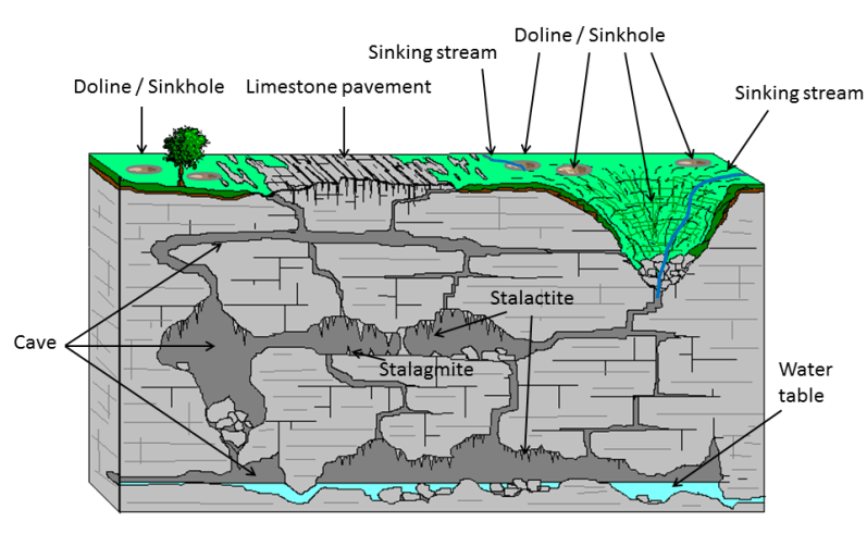
A type of topography or landscape characterized by the dissolution of soluble rocks, such as limestone and dolomite. The dissolution of the rocks leads to the formation of landforms such as sinkholes, caves, and springs. Water is often stored underground in karst landscapes, and thus they can form aquifers that provide sources of water for humans and animals. The sinkholes that form in karst environments are geological hazards that must be monitored and managed.
Here is a great figure showing some typical features of a karst landscape:
Most karst landscapes form in carbonate rocks, such as limestone or dolomite. In these rocks, the dissolution is caused by weak carbonic acid that forms when rainwater picks up carbon dioxide from the atmosphere and soil. In the open spaces of caves that form underground, the carbon dioxide in the water can be released, which causes the formation of speleothems, such as stalactites and stalagmites. If you’ve ever been in a cave with stalactites and stalagmites, then you’ve been in a karst landscape.
Below are a few pictures from Howe Caverns, a limestone cave in New York State that I recently visited with my family. You can visit an underground lake in this cave – and you can even take a boat ride on the lake! If you want to see a karst landscape up close, then I recommend a visit to Howe Caverns or another cave system.
Stalactites forming at Howe Caverns, New York State. Picture by myself.
Speleothems and other cave rocks reflected in an underground river at Howes Caverns, New York State. Picture by myself.
Gorgeous speleothems at Howe Caverns, New York State. Picture by myself.
Pictures of the boats you can take on the underground lake at Howe Caverns, New York State. Picture by myself.
That’s all for this week’s word. Stay tuned for next week!
Ice on a partially-frozen wetland pond, New Hampshire, November 2014.
def. Ice:
Water (H2O) in a solid state. When naturally occurring, ice is considered a mineral. There are many forms of ice: lake ice, river ice, sea ice, snow, glaciers, ice caps, ice sheets, and frozen ground (such as permafrost).
If you ask a geologist what he or she considers to be Earth’s most important mineral, you will probably hear many different answers, depending on the person. Some might choose a common mineral, perhaps olivine or quartz or feldspar. Others might choose a rare, economically valuable mineral, perhaps gold or tantalite or monazite. Others might choose a mineral that is important for understanding the geological history of the Earth, perhaps zircon or spinel or serpentine or maybe even jimthompsonite. However, if you ask me what I consider to be Earth’s most important mineral, I think that I would reply that it is ice.
After all, how many minerals have an entire field of geology devoted to them? Glaciology is a very important field of geology that is devoted to the study of glaciers and, more generally, ice in all its forms.
And how many minerals cover vast expanses of the Earth? Sure, much of the mantle consists of olivine and much of the core consists of metal alloys, but no other mineral can compete with ice when it comes to Earth’s surface. Ice covers much of the Earth’s land and ocean surface, and the portions of the Earth that are covered with ice comprise the cryosphere. Some scientists even believe that during particularly cold time periods in the past, the entire Earth, a so-called “Snowball Earth”, was covered with ice, an all-encompassing cryosphere.
And how many minerals play such an important role in Earth’s climate? The formation of ice is a key aspect of Earth’s climate system. Very simply, there is more ice when Earth is colder and there is less ice when Earth is warmer. However, the transition from water to ice and ice to water can be complex. For example, the light color of ice creates an ice-albedo feedback loop. Climatologists are still working to unravel the details of the roles that ice plays in global climate.
And how many minerals are less dense than their liquid counterparts? The lower density of ice relative to water enables it to float on top of water, and this physical arrangement has a profound impact on the nature of the hydrosphere and biosphere. If ice did not float on top of water, then many natural bodies of water might freeze completely, never fully thawing in the heat of summer. The lower density and greater volume of ice (compared to water) also plays a role in geomorphology. The expansion of water when it freezes into ice contributes to the physical weathering of rocks. The freezing and thawing of water breaks up rocks and is also responsible for other geomoprhological processes, such as solifluction.
I’m sure that there are many other reasons why ice is an important mineral. However, I think that the ones I’ve listed above are sufficient to convince me. If anyone asks me what I consider to be Earth’s most important mineral, I will answer ice… although since I currently work as a diamond geologist I might broaden the definition to include both frozen water and the sparkly gemstones I study at work.
But what would you answer? What is Earth’s most important mineral? What about Earth’s second most important mineral?
I have to admit, until I gave some thought to this week’s geology word I don’t think that I would have answered ice. I probably would have answered olivine, since I like mantle geology. However, that’s because I don’t generally think of ice when I think of minerals. I guess that ice is so common, and also so unusual (compared to other minerals), that it doesn’t fit into my standard “this is a mineral” box. There’s no doubt about it, though: ice is a mineral, and it is an important one.
Of course, not all ice is a mineral. The ice that you find in ice cubes in your drink is technically not a mineral since minerals must be naturally occurring by definition. My husband, who grew up in South Africa and only saw snow for the first time in his 20s, has a nice way of categorizing ice: he calls the ice that you find in your refrigerator “domesticated ice” and ice that you find out in nature “wild ice”. Growing up in a landscape without ice, my husband finds the “wild ice” of New Hampshire, where I come from, fascinating. And I suppose he should. For while a frozen puddle on the street, a line of icicles on a rooftop, and a dusting of snow on the driveway may seem quite ordinary to someone who grew up in a cold climate, they are small pieces of a quite extraordinary cryosphere that is an integral part of the planet we call home.
Snowy New Hampshire scenery, November 2014.Snow and glacier covered Denali in Alaska, 2013.
A simple 10x power folding hand lens, typical of the ones geologists carry into the field.
I’ve decided to bring back the long-lost “Geology Word of the Week” posts in 2015. For those of you who don’t know, for a few years I regularly posted about a geological word every week. These posts included a brief definition (written by me) of the word and then some additional information and pictures. However, starting in 2012 I stopped posting these words regularly. I was quite busy in 2012 because I defended my Ph.D. and then started working as an industry geologist. Then, for the past two years, my industry work has kept me extremely busy, and I’ve spent quite a bit of time in the field, far from home.
However, now that I’ve settled into a new industry job and will be spending a little more time in the office, I’ve decided that it’s time to revive the “Geology Word of the Week”. I will endeavor to post about a geological word every week. However, I may sometimes (perhaps more often than not, depending on how much time I have) keep the posts very short. For some words, I may just provide the definition and a picture or two. Regardless, I think that such posts will be interesting and informative and will help both amateur and professional geologists (including myself!) improve their geological vocabulary. Also, depending on my work schedule, I may occasionally have to skip a week or two. I’ll try not to skip too many, though!
For the “Geology Word of the Week” posts I go through the alphabet from A to Z to select my words. I made my way through two alphabet cycles before I stalled at G is for Glacial Erratic. I’m picking up the alphabet where I left off, so this week’s word starts with H. By the way, you can browse all of the previous geological words here.
Without further ado, here is this week’s geology word:
def. Hand Lens:
A small magnifying glass used by geologists to take a closer look at rocks. Commonly, hand lenses have 10x magnification power and fold into protective metal cases. Geologists use hand lenses to help identify minerals and fossils in rocks and also to take a closer look at rock textures and structures. Hand lenses can also be used to take a closer look at soft rocks such as soils and sand grains. A hand lens is an essential part of a geologist’s field equipment, and many geologists wear a hand lens on a string around their neck when they venture out into the field. Hand lenses are also useful for looking at rocks, sediment cores, and other geological samples in a laboratory.
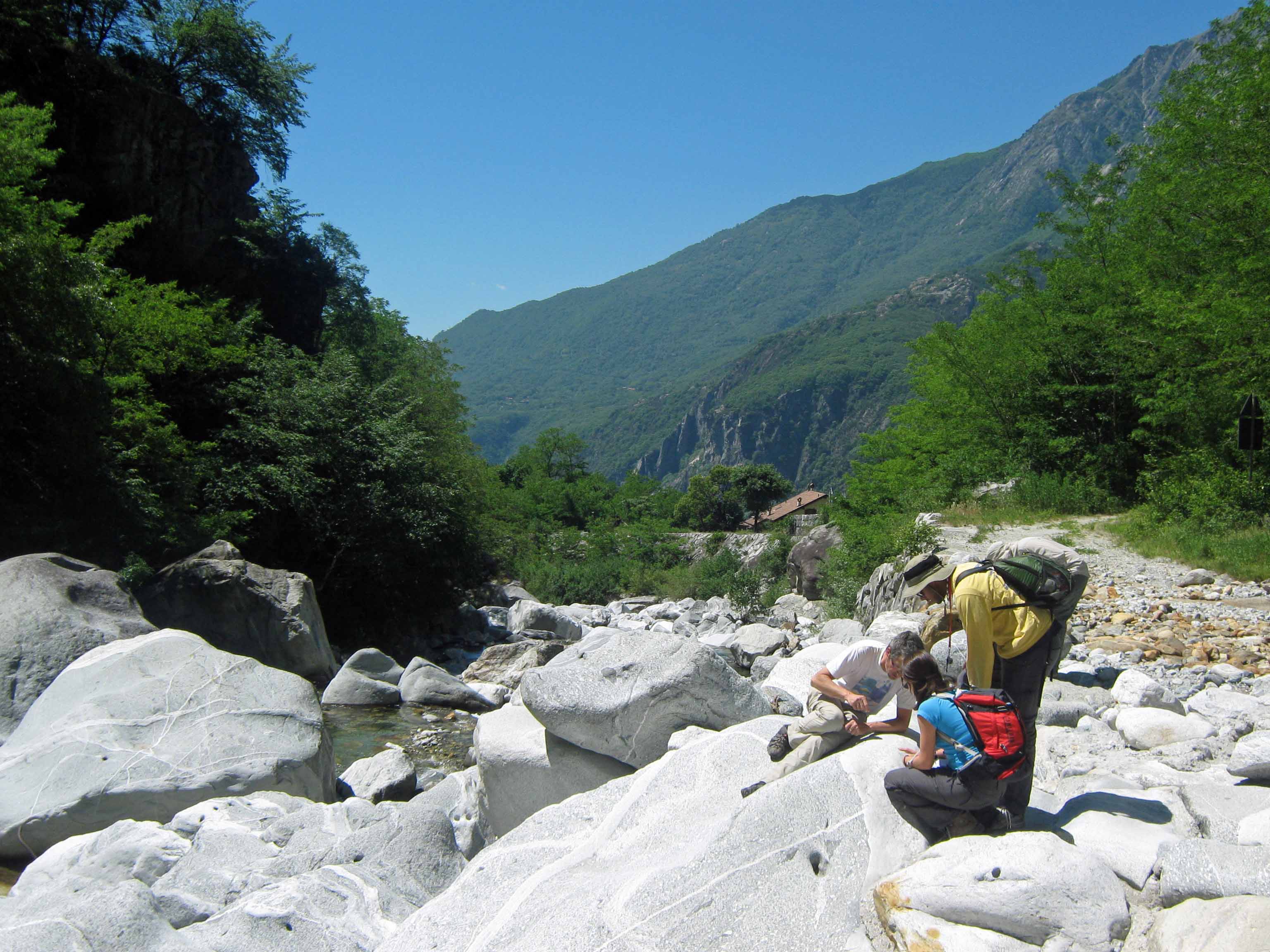
Here are a few pictures of geologists using hand lenses in the field:
Three geologists taking a close look a boulder with their hand lenses.A geologist taking a good look through a hand lens.A geologist preparing to take a good look at a mineral grain through a hand lens.
That’s it for this week’s geology word… stay tuned for next week!
Me, standing on top of a glacial erratic boulder in Nome, Alaska, Summer 2012.
def. Glacial Erratic:
A rock which has been transported and deposited by a glacier and which has a different lithology than the rock upon which it has been deposited. Often, erratic rocks have an angular shape because they were broken off of bedrock by glaciers and have not yet had time to be weathered and rounded by water, wind, and other erosional forces. Glacial erratics can range in size from very small pebbles to very large boulders, but usually it is the boulders which are noticed since these stand out in the landscape and are not easily transported away again.
Recently, I have been thinking a fair amount about glacial erratics and other glacial rocks and deposits, such as tills and moraines. That’s because I currently work for a marine gold exploration company that has a project offshore Nome, Alaska, where glaciers have transported gold to the coast along with erratics and other glacial sediments. If you walk along the beaches of Nome, you can spot quite a few glacial erratics, such as the one I’m standing upon in the above picture.
Another glacial erratic on the beach in Nome, Alaska, Summer 2012. Pen for scale.
Having grown up in New England, I’m no stranger to glacial erratics. In fact, back in September I wrote a little about my favorite glacial erratic, which sits on an island in front of my parents’ lakeside cabin in New Hampshire.