
This will be the new home of my blog Georneys. I’ll be moving all of my posts here from the AGU blogosphere – and starting some new blogging in 2024. Stay tuned!
Category: Uncategorized
Georneys is Moving – and Where to Find Me


AGU has announced that it will be sunsetting the AGU Blogosphere. So, I am here to say goodbye – and to thank AGU for years of hosting my blog.
I started blogging for the AGU Blogosphere in 2011, when I was in graduate school. I’ve enjoyed my time blogging here over the years, particularly my “What to Buy a Geologist for Christmas” and my “Geology Word of the Week” posts. In recent years, as I’ve moved countries (twice!), gotten married, become a mother, and had a busy career in geology and climate change management, my blogging has become more intermittent. I was just starting to gain momentum with my blogging again last year when I received an email that the blogosphere would be shutting down. I didn’t have the heart, for a few months, to put up new posts. However, I plan to migrate all of my posts over to my new blog site – evelyngeorneys.com. I do hope that I can revive the blog there, even if I only post a couple of times a month.
In the meantime, I have started up an Instagram page @evelyn_georneys where I am sharing a geology picture (with a little geology information) every day. I shared my first daily picture there on January 1st – and today I’m up to my 50th picture. Sometimes I share a picture of a rock or mineral that I saw that day. Other times I share a picture from my 20+ years of geological adventures.

In addition to following me on my new blog site and on Instagram, you can also connect with me on LinkedIn.
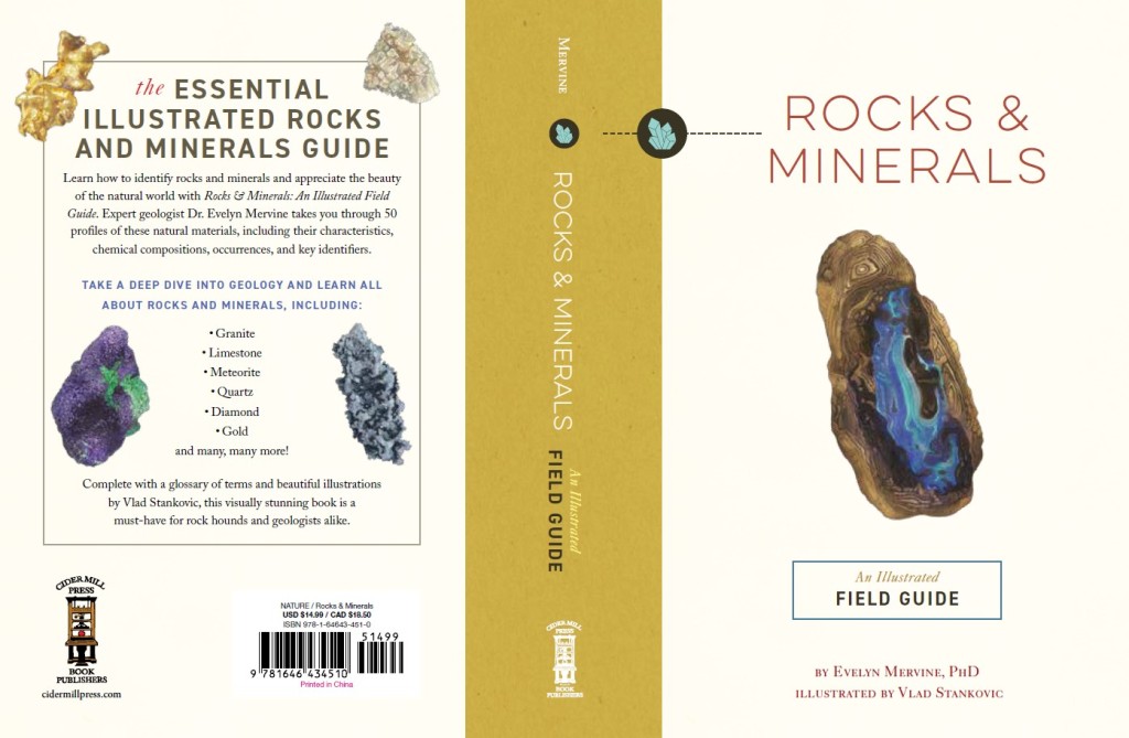
Last but certainly not least, I want to announce that I published my first book Rocks & Minerals: An Illustrated Field Guide in December with Cider Mill Press (an imprint of HarperCollins). In this book, I describe 20 common rocks and 5 rare rocks and 20 common minerals and 5 rare minerals, including elkinstantonite named after the fabulous Lindy Elkins-Tanton. The book is not intended to be a comprehensive guide but rather a fun tour through the world of geology. I have included a fun fact about each rock and mineral (well, I think they’re fun, anyway!). The rock and mineral profiles are accompanied by beautiful illustrations by the very talented Vlad Stankovic. If you would like a copy, you can find it on Amazon or buy it from your local bookseller. I hope that you enjoy my book.
Without further ado, I must say farewell. Hope to see some of you on Instagram and elsewhere!
Monday Geology Picture: Namibian Desert Landscape

While I’m busy reviving Georneys, I thought that I should revive my “Monday Geology Picture” posts. Today’s picture features a Namibian desert landscape along the road to Fish River Canyon in Namibia. After I finish blogging about the International Geological Congress, which I’m attending this week, I’ll blog about my recent hike through the canyon. I plan to write up a post on the geology of the canyon, so stay tuned! In the meantime, enjoy this scenic view as a preview.
Monday Geology Picture: West Coast Fire
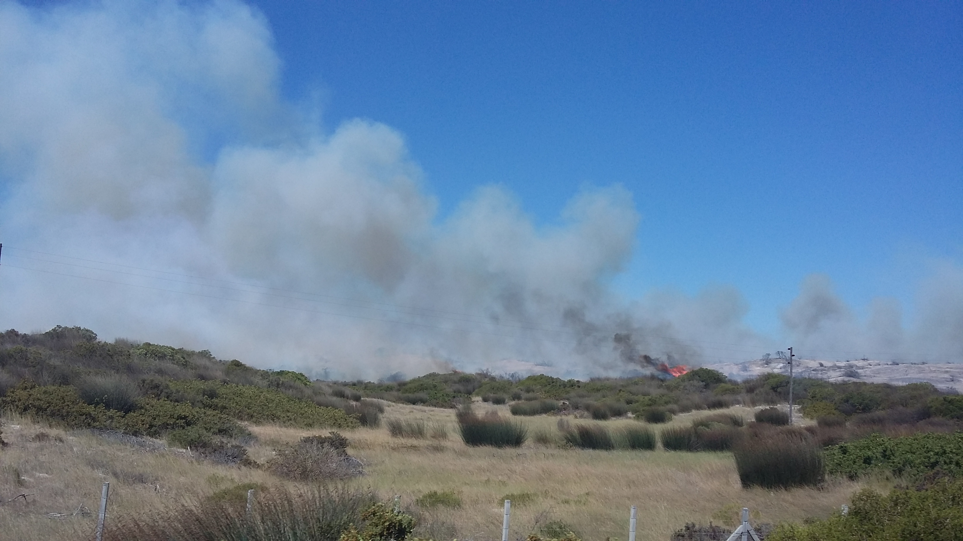
Here in South Africa it’s fire season again. So far, this summer has been very hot and dry with many parts of the country suffering from drought. Over the past few weeks, there have been several forest fires around the Western Cape province. About a week ago we drove past a moderate size fire when we were driving back from Langebaan Lagoon. Fortunately, it seems that firefighters contained this particular fire fairly quickly. Hopefully there won’t be too many devastating fires this year, especially considering that many parts of the forest were burned last year.
LASI V: Field Trip Introduction
Back in late October and early November 2012, I attended the LASI V Workshop on the “physical volcanology of subvolcanic systems: laccoliths, sills, and dykes” as an observer and science writer. The workshop started out with 2 days of talks at the Pine Lodge Conference Centre in Port Elizabeth, South Africa. Recently, I have been writing about some of the research that was presented during these talks. I’ve already written about Dr. Volcano in the Cave of Crystals, Naica, Mexico and Xeno-Pumice: Mysterious Floating Rocks of the Canary Islands, and there’s more coming soon! However, I thought I should also start sharing some information about the wonderful LASI V field trip, especially since some of the research presented during the talks was about the remarkable subvolcanic systems that can be observed in South Africa’s Karoo Basin.
Today, I just want to give a quick introduction to the field trip route and the locations visited. In my next field trip post, I’ll give a general overview of Karoo Basin geology. Then, I’ll share some information and plenty of pictures from the various LASI V field trip stops. We visited so much great geology that I might not have time to cover everything, but I’ll do my best!
The LASI V field trip lasted 3 days. The map below shows the main locations visited during the field trip.

Here are the places that we visited during the field trip:
Day 1: We drove from Port Elizabeth to Aloe Grove, which is located just outside of Queenstown. On the way, we visited outcrops of Dwyka tillite and Ecca Group deep to shallow marine sediments. We also visited Elandsberg Mountain, where dolerite sills have been intruded into fluvial sandstones of the Beaufort Group. While we were at Elandsberg, we spent quite a bit of time looking at a dolerite sill with impressive spheroidal weathering. Finally, we visited Waterdown Dam, where there are some remarkable granophyre dykes that were produced by the interaction of dolerites and sedimentary rocks.
Day 2: We spent all day exploring the saucer-shaped sill complexes in the Golden Valley.
Day 3: We visited a place known as Witkop III, a hydrothermal vent complex.
That’s all for now. More about the field trip soon!
LASI V: Biological Interlude #2
I’m still busy writing up some more exciting geology posts related to the LASI V workshop, but meanwhile here’s another biological interlude.
You may remember that back in October I wrote about an interesting monkey warning sign at Pine Lodge, the venue for the LASI V talks.
A day later, I walked out of my room to go over to breakfast and– sure enough– encountered a vervet monkey.


A Slight Change in the Usual Programming…
Firstly, my apologies for the recent lack of my regular posting, such as the Geology Word of the Week. For the past couple of weeks, Georneys has been quiet because my blog was experiencing some technical difficulties. I was unable to upload any pictures because my blog had reached its allocated server space. I guess I’ve just been posting so many great geology pictures! A few Monday Geology Picture posts did appear because I had scheduled those as autoposts. Due to the holidays, it took a little while to sort out my blog, but Georneys should be up and running as usual now.
Secondly, I want to let my readers know that there will be a slightly change in the posts for Georneys over the next several weeks. I am going to put the Geology Word of the Week on hold (again) as I have some other blogging to catch up on. I have several articles to post relating to interviews that I conducted during the LASI V workshop back in October 2012, and I also plan to write some about the wonderful LASI V field trip to South Africa’s Karoo region. I will also be posting some articles about my trip in June 2012 to visit Dr. Ken Glennie, a well-known sedimentologist and petroleum geologist. Last but not least, I will be devoting some time to working on a couple of research manuscripts that are underway. Combined with my day job, I imagine I will be quite busy! The Monday Geology Picture posts will appear as usual.
I hope that you will enjoy the slight change in the programming here on Georneys. Never fear– once I’ve caught up on some of my other posts, the Geology Word of the Week shall return.
Newspaper Clippings from the 1964 Alaska Earthquake at Gwennie’s

I’d like to write a few more posts about my visit to Alaska earlier this year. In case you missed them, here are some earlier posts about Alaska:
Geology Word of the Week: G is for Glacial Erratic
A Drive to Salmon Lake, Alaska in Pictures
Nome, Alaska in Pictures: Part I
Nome, Alaska in Pictures: Part II
Nome, Alaska in Pictures: Part III
Monday Geology Picture(s): Garnet Sands in Nome, Alaska
Plane Views: Anchorage to Nome
Plane Views: Minneapolis to Anchorage
And, last but not least…
Whale Carcass on the Beach in Nome, Alaska
Clearly, I’ve already shared a fair amount about the two months I spent in Alaska. However, I still have some more to share! I’ll start out with a post about Anchorage and a very big earthquake.
My husband Jackie and I spent a few days in Anchorage back in July before traveling up to Nome, where we spent the months of August and September doing field work. One day when we were in Anchorage we had lunch at a place called Gwennie’s Old Alaska Restaurant, a place that had been recommended to us by some locals.

Gwennie’s is full of kitsch and crazy: taxidermied animals and antlers are strewn about everywhere, and in-between one finds everything from Iditarod posters to stained glass windows depicting gold prospectors. The food is served on cheap plates with cheap cutlery, but it’s pretty good. Both my husband and I enjoyed the reindeer sausage with fries and a large drink since we were dehydrated from running errands all over Anchorage on a beautiful, sunny, warm summer day.


Jackie and I enjoyed looking at all of Gwennie’s unusual decorations, most of which had an Alaskan theme. As we were wandering around looking at the various decorations, one of the waitresses suggested that we go over to the bar to take a look at all of the newspaper clippings from the 1964 Alaska earthquake. This earthquake was enormous, registering 9.2 on the Richter Scale. For reference, that’s the same magnitude as the 2004 Indian Ocean earthquake that created the large tsunami that devastated parts of Asia. Jackie and I had heard and read about the 1964 Alaska earthquake before, but seeing the newspaper clippings and pictures really put the earthquake in perspective. The clippings put a human face on the earthquake, which was so destructive that some Alaskan towns never bothered to rebuild but simply were abandoned. Looking at the pictures of the earthquake’s destruction was fascinating, humbling, and awe-inspiring.
Here are some of the earthquake newspaper clippings that we saw at Gwennie’s:


If you’re ever in Anchorage, I highly recommend going to Gwennie’s for a bite to eat and a look around. At least have a drink and take a look at the earthquake newspaper clippings.
Geology Word of the Week: G is for Glacial Erratic

def. Glacial Erratic:
A rock which has been transported and deposited by a glacier and which has a different lithology than the rock upon which it has been deposited. Often, erratic rocks have an angular shape because they were broken off of bedrock by glaciers and have not yet had time to be weathered and rounded by water, wind, and other erosional forces. Glacial erratics can range in size from very small pebbles to very large boulders, but usually it is the boulders which are noticed since these stand out in the landscape and are not easily transported away again.
Recently, I have been thinking a fair amount about glacial erratics and other glacial rocks and deposits, such as tills and moraines. That’s because I currently work for a marine gold exploration company that has a project offshore Nome, Alaska, where glaciers have transported gold to the coast along with erratics and other glacial sediments. If you walk along the beaches of Nome, you can spot quite a few glacial erratics, such as the one I’m standing upon in the above picture.

Having grown up in New England, I’m no stranger to glacial erratics. In fact, back in September I wrote a little about my favorite glacial erratic, which sits on an island in front of my parents’ lakeside cabin in New Hampshire.

Monday Geology Picture(s): Some Teaser Shots from LASI V

For this week’s “Monday Geology Picture” post I thought I would share a few teaser pictures from the field trip I attended last week as part of the LASI V workshop on the physical volcanology of laccoliths, sills, and dykes. For the field trip, we spent three days exploring and learning about subvolcanic systems that are exposed in South Africa’s Karoo region. We stayed just outside of the town of Queenstown and went on field trips in the area. In future posts I’ll be writing in detail about the geology that we saw on the field trip. In fact, I’m spending some time working on my first proper LASI V post this evening. You can expect it later this week. For now, enjoy these teaser pictures!


