

Last week, I shared some pictures of some dassies or rock hyraxes along the Breede River. This week, I thought I would share another picture of dassies in the Cape Town, South Africa area, courtesy of my friend Joy.
Last week, I shared some pictures of some dassies or rock hyraxes along the Breede River. This week, I thought I would share another picture of dassies in the Cape Town, South Africa area, courtesy of my friend Joy.
Note: Dr. Olivier Galland, a senior researcher at the Physics of Geological Processes Center of Excellence at the University of Oslo, presented a talk, “Ground deformation associated with shallow magma intrusions” at the LASI V conference in Port Elizabeth, South Africa in October 2012. The article below is based on this talk and also an interview with Dr. Galland. Over a few weeks, I am highlighting some of the research that was presented at the LASI V workshop. This is the fourth post in that series.
The landscape around an active volcano is dynamic: as magma moves about, the ground may change shape, inflating or deflating depending on how the magma is moving (Steps 1-2 of Fig. 1). The deformation may be caused either by the deep movement of magma or by the shallow intrusion of magma as sills or dykes. The movement can be dramatic (hundreds of meters) or it can be barely noticeable (a few millimeters). Big or small, ground deformation at volcanoes is important to monitor as it can provide clues to what is going on under the surface and, importantly, about when and where a volcanic eruption might occur.
At many volcanoes, geologists monitor ground deformation using a variety of techniques, including physical devices such as GPS and tiltometers, remote sensing techniques such as InSAR, and photogrammetry, which is the analysis of photographic images (Step 3 of Fig. 1). From surface measurements of ground movements, geologists can try to model what is going on underneath the surface (Step 4 of Fig. 1). However, linking observations of surface deformation to magma movements is no easy task (Step 5 of Fig. 1). That’s because geologists cannot generally directly observe the insides of a volcano. An analogy might be trying to understand why a kitchen sink is broken—why it is leaking or not flowing, perhaps— without being able to open up the cabinet door and look at the sink’s plumbing. Geologists can observe ancient volcanic plumbing, so to speak, in places where the tops of volcanoes have eroded away. However, observing the plumbing of active volcanoes is very difficult to impossible. Therefore, geologists generally rely on fancy computer models to try to link surface deformation with subsurface magma movement.

Computer models are extremely helpful in trying to understand the insides of active volcanoes. However, they do have their limitations. This is because the shapes of magma chambers and shallow magma intrusions can be complex. Computer models can easily accommodate simple shapes such as circles or flat bodies. However, they have a harder time simulating more complex shapes, such as cones or saucers. Computer models also have trouble taking into account all environmental factors, such as the various stress fields and the realistic behavior of rocks. Finally, it is difficult to be completely confident in the results of computer models since the results of such models cannot generally be compared with direct observations.
One way to try to bridge the gap between surface observations of ground deformation and subsurface movements of magma inferred through computer models is through laboratory experiments. Dr. Olivier Galland is one scientist who conducts such experiments. Dr. Galland describes his experimental set-up (Fig. 2a) as, “Actually, it’s very simple. It’s just a box filled with silica flour, which is a fine-grained, granular material that is simulating the brittle crust. And into that material I inject a vegetable oil, which represents the magma, and the pressure of that oil is monitored. And then it’s possible to simulate the transport of magma and the formation of dykes and sills in this box.” Although such procedure seems simplistic, robust dimensional analysis of the method shows that the experimental results at the lab scale are valid at the geological scale.

In a recent experiment (Galland, 2012) Dr. Galland used this silica flour and vegetable oil set up to simulate three types of shallow magmatic intrusions: a cone sheet, a dyke connected to a cone sheet, and a saucer-shaped sill. The motivation for this experiment was to provide additional data about the deformation that occurs when these shallow magmatic bodies are emplaced and, in addition, the deformation that occurs when they breach the surface and erupt. While the silica flour and vegetable oil set-up can’t simulate everything about a real volcano, it can provide plenty of important information, especially about the shapes of various intrusions and the pressures of the magma which produces these intrusions. This is possible because the oil is solid at room temperature, such that the final intrusion can be excavated out of the silica flour and its 3D shape analyzed (Fig. 2c).
Dr. Galland explains, “When a volcano is about to erupt or as it is erupted it either inflates or deflates, and this movement can be monitored. And then afterwards this movement is analyzed and inverted by geophysicists who try to calculate the geometry of the magma conduits. The problem is that we can never test these modeling results because we don’t see the intrusions because they are buried. The only way to really test these inversion techniques is to have a system where you measure the deformation and also know the shape of the intrusion and the pressure into the intrusion. And this is what we are doing in our experiments. We can quantify the shape of the intrusion and measure the pressure into the intrusion and measure the surface deformation, and then we can use this dataset to help test the inversion tools used by the geophysicists.”
Already, Dr. Galland’s experimental work is providing some interesting clues as to what is going on under the surface at volcanoes. “Recently, we figured out that there is clearly a link between how magma rises towards the surface and the pattern of the deformation at the surface,” Dr. Galland says. “Interestingly, this pattern develops very early during the experiments in the very early stages. So, we can observe some asymmetric development of this pattern which indicates where the magma is rising. So, if we can analyze that in real time, we could theoretically use it to predict where an eruption will occur. Obviously, in terms of volcanic hazard that is very important.” This is illustrated in the Figure 3, which shows the good match between the shape of the intrusion with the resulting ground deformation.

However, Dr. Galland doesn’t spend all of his time in the laboratory. He believes that it is important for him to regularly go into the field to directly observe volcanoes, modern and ancient. He is particularly interested in observing subvolcanic systems, such as the saucer-shaped sills exposed in South Africa’s Karoo region and intrusive complexes formed in compressional settings exposed in the Neuquén Basin in the north Patagonian Andes. Dr. Galland explains, “My approach is to go to the field and really observe and do some detailed work and then out of that comes a question and then these questions can be subsequently addressed with experiments.” After all, that field knowledge is important for turning silica flour into the Earth’s crust and vegetable oil into magma.
Reference:
Galland, O. 2012. Experimental modelling of ground deformation associated with shallow magma intrusions. Earth and Planetary Science Letters, Vol. 317-318: 145-156.
***Note: Thanks very much to Dr. Galland for providing the three figures and captions.***

This past weekend my husband and I traveled down to Robertson, South Africa to visit family. We’ve been wanting to do a river trip for awhile, so we booked a kayaking trip along the Breede River for Saturday. The Breede is a very beautiful river, and we saw some incredible birds– most of which flew away before we could take a good picture of them! We stopped for a snack and some swimming near the uplifted (nearly vertical!) sandstone rocks in the above picture. We were taking a look at the rocks when we noticed some movement amongst them.The rocks, as it turned out, were full of dassies or rock hyraxes. The dassies kept darting out from the rocks and hopping and waddling (they’re pretty fat!) down to the river for a drink on the hot summer day.
Here are a few pictures of the dassies:


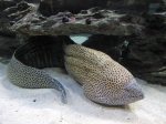
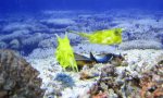
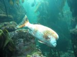
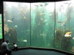
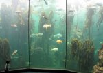
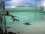
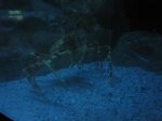
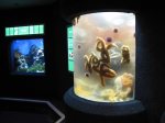
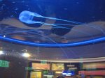
Today my husband and I visited the Two Oceans Aquarium in Cape Town, South Africa. I highly recommend a visit to the aquarium for anyone in the area. Below is a gallery of a few pictures from our visit. Enjoy! Click on any of the pictures below for a larger version.


Back in late October and early November 2012, I attended the LASI V Workshop on the “physical volcanology of subvolcanic systems: laccoliths, sills, and dykes” as an observer and science writer. The workshop started out with 2 days of talks at the Pine Lodge Conference Centre in Port Elizabeth, South Africa. Recently, I have been writing about some of the research that was presented during these talks. I’ve already written about Dr. Volcano in the Cave of Crystals, Naica, Mexico and Xeno-Pumice: Mysterious Floating Rocks of the Canary Islands, and there’s more coming soon! However, I thought I should also start sharing some information about the wonderful LASI V field trip, especially since some of the research presented during the talks was about the remarkable subvolcanic systems that can be observed in South Africa’s Karoo Basin.
Today, I just want to give a quick introduction to the field trip route and the locations visited. In my next field trip post, I’ll give a general overview of Karoo Basin geology. Then, I’ll share some information and plenty of pictures from the various LASI V field trip stops. We visited so much great geology that I might not have time to cover everything, but I’ll do my best!
The LASI V field trip lasted 3 days. The map below shows the main locations visited during the field trip.

Here are the places that we visited during the field trip:
Day 1: We drove from Port Elizabeth to Aloe Grove, which is located just outside of Queenstown. On the way, we visited outcrops of Dwyka tillite and Ecca Group deep to shallow marine sediments. We also visited Elandsberg Mountain, where dolerite sills have been intruded into fluvial sandstones of the Beaufort Group. While we were at Elandsberg, we spent quite a bit of time looking at a dolerite sill with impressive spheroidal weathering. Finally, we visited Waterdown Dam, where there are some remarkable granophyre dykes that were produced by the interaction of dolerites and sedimentary rocks.
Day 2: We spent all day exploring the saucer-shaped sill complexes in the Golden Valley.
Day 3: We visited a place known as Witkop III, a hydrothermal vent complex.
That’s all for now. More about the field trip soon!

For this week’s Monday Geology Picture post, I thought I would share some pictures which I took last month on a beach in Port Elizabeth, South Africa. As I was walking along the beach with my husband and some friends, we came across a pile of rounded pebbles of various lithologies. Some of the rounded pebbles seem to be anthropogenic in origin– I think they are rounded pieces of brick.


More geology posts about the LASI V workshop are coming, but meanwhile here’s another biological interlude. One day during the Karoo field trip, we spotted a dung beetle. Dung beetles are pretty neat little critters, actually. And they can move balls of dung remarkably quickly!


I’m still busy writing up some more exciting geology posts related to the LASI V workshop, but meanwhile here’s another biological interlude.
You may remember that back in October I wrote about an interesting monkey warning sign at Pine Lodge, the venue for the LASI V talks.
A day later, I walked out of my room to go over to breakfast and– sure enough– encountered a vervet monkey.


So, I’ve been meaning to put up another LASI V post or two, but I’ve been extremely busy with my day job over the past few weeks. I hope to have another substantive LASI V post up soon, but in the meantime here’s a lovely biological interlude post that contains pictures of some vegetation which I observed during the LASI V field trip to South Africa’s Karoo. As I geologist, I generally dislike vegetation since it covers up all the pretty rocks. Sometimes, though, vegetation is pretty enough that I don’t mind it too much. If any botanists read this post and know about the vegetation in the pictures, please enlighten us geologists!
Observed on Day #1 of the LASI V Field Trip:


Observed on Day #2 of the LASI V Field Trip:


Observed on Day #3 of the LASI V Field Trip:


This week I thought I would I share a picture of my beautiful sister-in-law Bonita on her honeymoon in Mpumalanga, South Africa back in September. In the above picture Bonita is standing in front of a geological feature known as “The Three Rondavels”.
A rondavel is a type of traditional African house which is circular in shape. Here’s a picture of a rondavel in the Karoo region of South Africa:

My sister-in-law and her husband saw some other geological wonders on their honeymoon. Be sure to check out the previous posts on Berlin Falls and Bourke’s Luck Potholes. I’ll probably be sharing some more pictures from their honeymoon, too!
