Fish River Canyon, viewed from the start of the hiking trail.
This week I’m sharing another view of Fish River Canyon in Namibia. This week’s picture shows the canyon as viewed from the start of the hiking trail. In the foreground you can see the very start of the hike: a steep path downwards with some safety chains.
Also check out last week’s picture, which was taken at the bottom of the canyon.
Hiking Fish River Canyon back in 2016. This picture was taken during the first day of the hike.
This week I’m sharing a picture from Fish River Canyon in Namibia. This remote and beautiful canyon has some stunning geology – I’ll blog more about it when I have a chance. Back in 2016 I hiked the canyon over 5 days with a group of good friends. I highly recommend the trip, although you should make sure that you’re really fit since I found the backpacking to be quite challenging at times. There is not a proper trail through much of the canyon, so you follow the riverbed walking through the sand (very tiring) and sometimes over patches of large boulders (even more tiring!). All the hard hiking is worth it, though — the canyon is one of the most stunning places I have ever been.
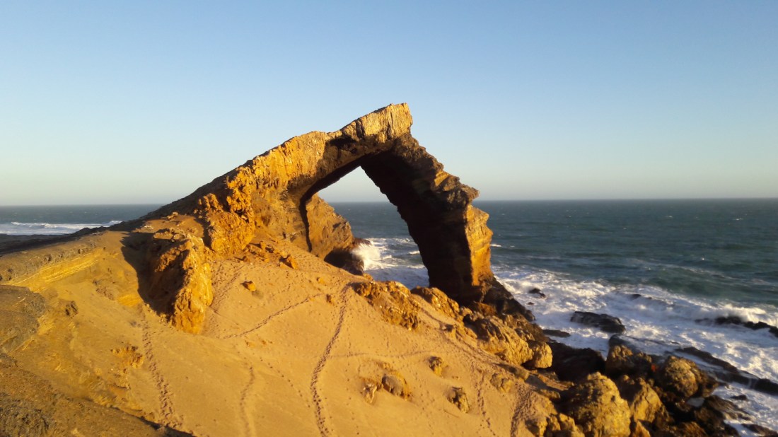
I’m up in Namibia this week, so I thought it would be appropriate to share a picture that I took over the weekend of Bogenfels Rock Arch, which is located in the Sperrgebiet region of Namibia.
I previously posted a similar picture back in 2015. See that post for some more information on the arch and the Sperrgebiet.
A sand dune slowly taking over a room in Kolmanskop.
For this week’s “Monday Geology Picture” here’s a picture of a spectacular sand-filled room in a house in the ghost town of Kolmanskop, Namibia. I visited this diamond mining ghost town back in 2014, and you can find more pictures from that visit here. If you ever visit Namibia I highly recommend a visit to Kolmanskop!
Migmatite hills and a pretty blue fence that matches the pretty blue sky.
I was a little sporadic with my “Monday Geology Picture” posts in 2016. I’ll try to be more consistent in 2017!
To start off, here is a shot of a lovely little hill of migmatite in the town of Lüderitz, which is located at the edge of the Namib desert in the beautiful country of Namibia. I took this picture when I was up in Namibia back in 2014.
Happy New Year… and stay tuned for more lovely geology pictures. Feel free to submit an interesting picture, if you like!
A view of the Namibian night sky. Picture taken by Jackie Gauntlett in the middle of the Sperrgebiet, June 2015.
My husband and I spent some time doing field work in the Sperrgebiet region of Namibia earlier this year. We camped out in the desert for a few days. We spent our days looking at some fantastic geology, and we spent our nights looking at some fantastic views of the night sky. We were quite far from any towns, so we had very little light pollution and could see many stars. We bought a fancy(ish) camera earlier this year, and my husband has been playing around with taking shots of the night sky. Above is one image that he took during our recent field work up in Namibia. Enjoy! Click the picture for a larger version.
My apologies that I’ve been very quiet here on Georneys recently. My travel and work schedule were extremely hectic during the past month… plus I was working on a couple of scientific papers related to my PhD thesis research. However, life is a bit calmer now, so hopefully I’ll catch up on some blogging soon! I want to share some more pictures from my trip to Australia, amongst other things.
I’ll start with a few pictures from my recent trip to Namibia. Recently, I had the good fortune to spend a couple of weeks in the Sperrgebiet in Namibia doing some fieldwork on behalf of De Beers. I do not blog about my industry work here on Georneys (unless the work is published and thus in the open domain), so I can’t share the details of my trip. However, I can share a few pictures of some of the “tourist attractions” that I saw during my field work.
Sperrgebiet means “Prohibited Area” in German (the Germans colonized Namibia, so some German words and town names are still found in the country). The Sperrgebiet is an area in southern Namibia (stretching between Lüderitz and Oranjemund) where very rich placer diamond deposits are found. Since the early 1900s, access to this area has been highly restricted. Even for De Beers employees, special police clearances and permits are required to enter the area, and security remains strict. However, for those who do have access, the Sperrgebiet is a fascinating and magical place. Aside from the fantastic hard rock and sedimentary geology (and wildlife!) that one can see, the area contains a number of historical and archaeological sites. There are a number of abandoned diamond mining “Ghost Towns” that are weathering away in the desert, pretty much undisturbed (by humans, anyway) since they were abandoned tens of years to more than a hundred years ago. For the general public, it is extremely difficult to enter the Sperrgebiet. However, there is one tour company that operates a day trip (from Lüderitz) to Pamona, one of the abandoned diamond mining towns, and the Bogenfels Rock Arch, which is the subject of today’s post. If you ever find yourself in southern Namibia, I highly recommend the tour although you must remember to submit paperwork for the tour well in advance. Even tourists require a permit to enter the Sperrgebiet!
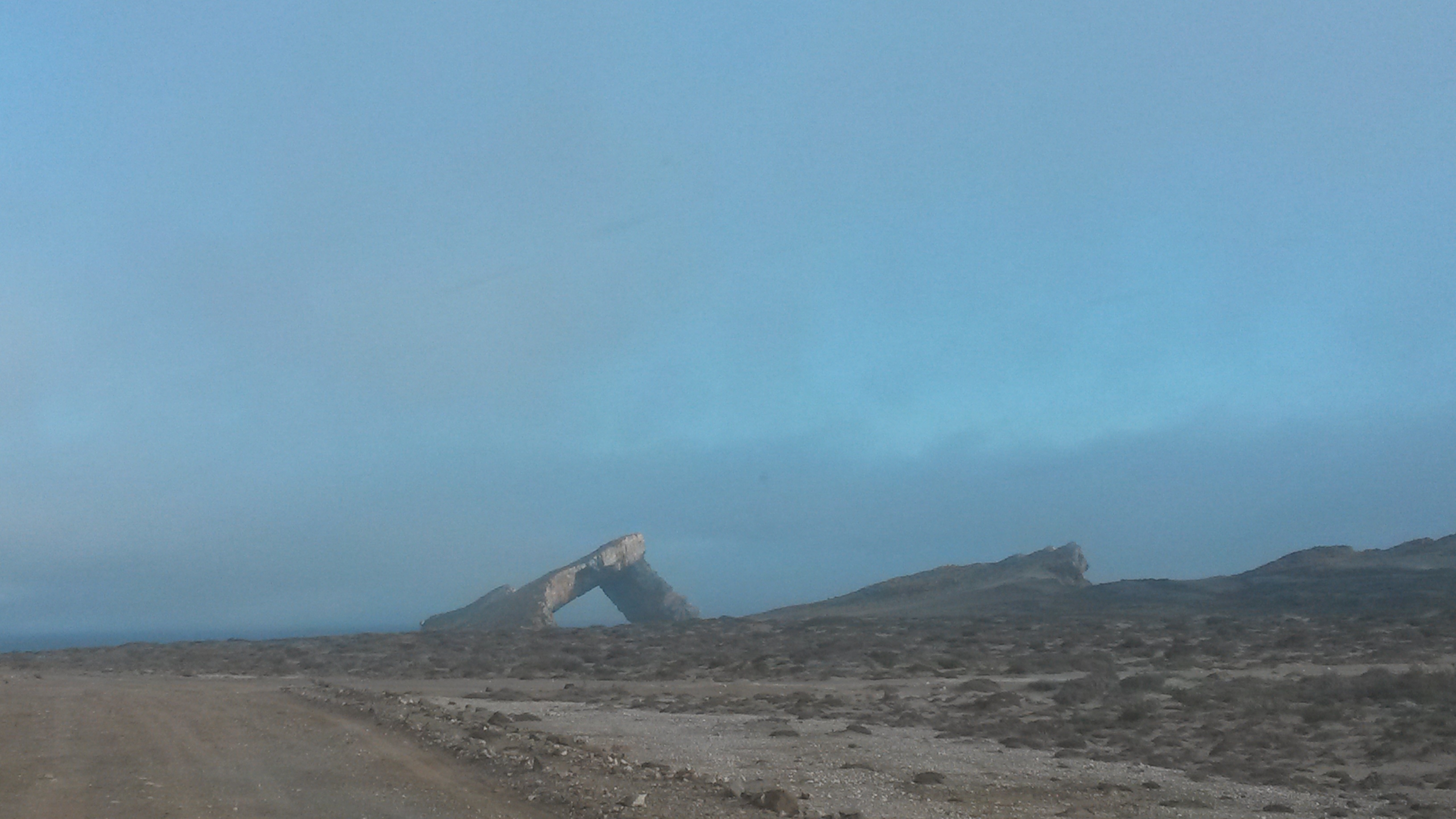
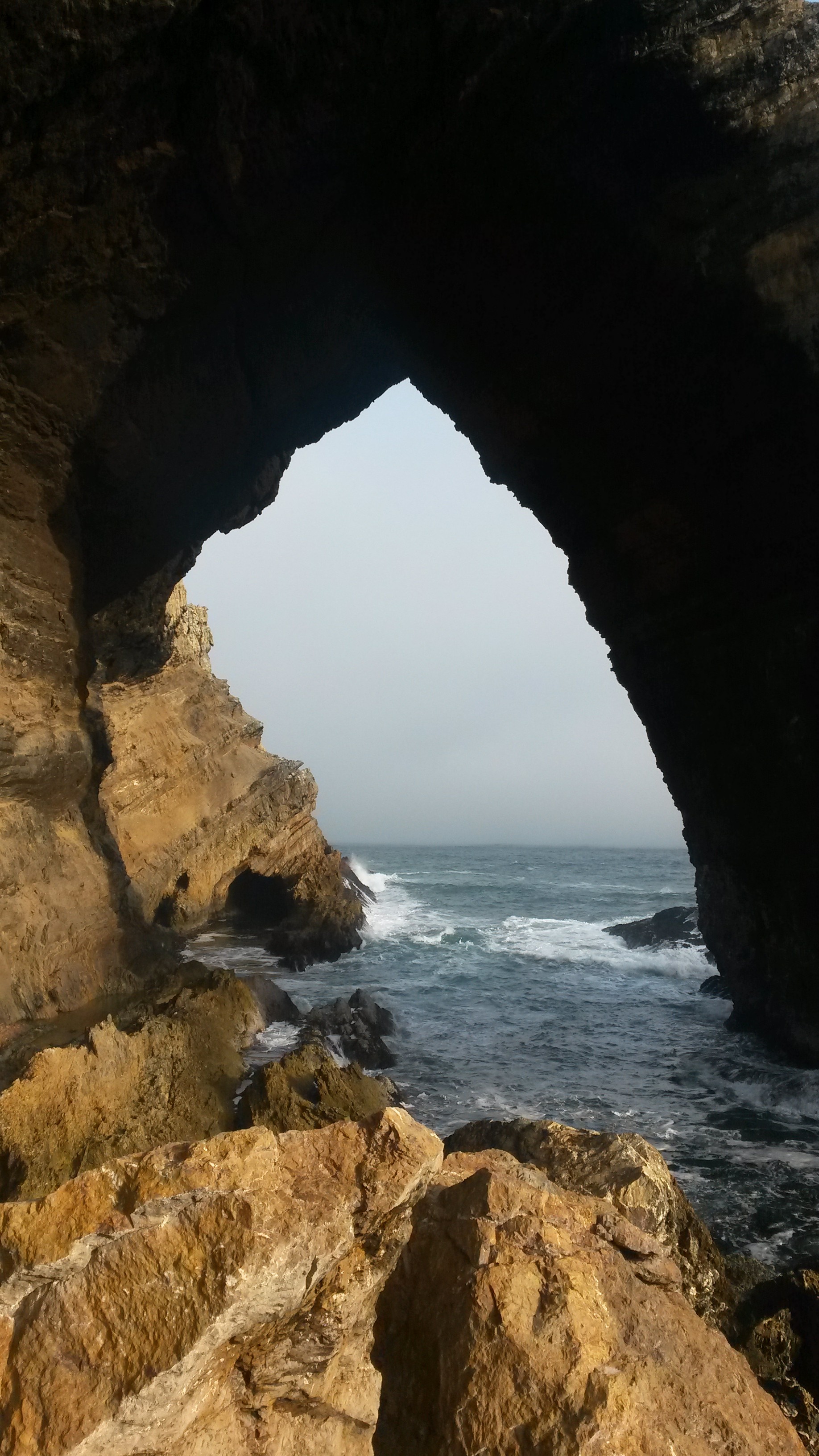
Without further ado, I present a few more pictures of the impressive Bogenfels Rock Arch below. From what I understand “Bogenfels” actually means “Rock Arch” in German. Certainly, the arch is an impressive feature located right on the coastline.
Bogenfels Rock Arch #2 – from a distance.Bogenfels Rock Arch #3.Bogenfels Rock Arch #4.
That’s all for now… stay tuned for a few more pictures from Namibia!
Apologies for the recent gap in my blogging. I’ve been busy travelling for work, and our home internet connection was not working for a couple of weeks. We’ve also been suffering from regular power outages here in South Africa.
Anyway, to make up for my recent quietness, I’m sharing a spectacular picture for this week’s “Monday Geology Picture” post. This picture was taken close to the border between South Africa and Namibia near the town of Oranjemund and shows a salt pan that is called “Pink Pan” by locals. The Orange River is in the background of the picture. I took this picture through an airplane window when I was flying from Oranjemund to Windhoek earlier this month.
Apologies for the short hiatus in my blogging. I’ve been travelling and generally very busy with work these past two weeks. However, I have another “Geology Word of the Week” post coming up soon, so stay tuned!
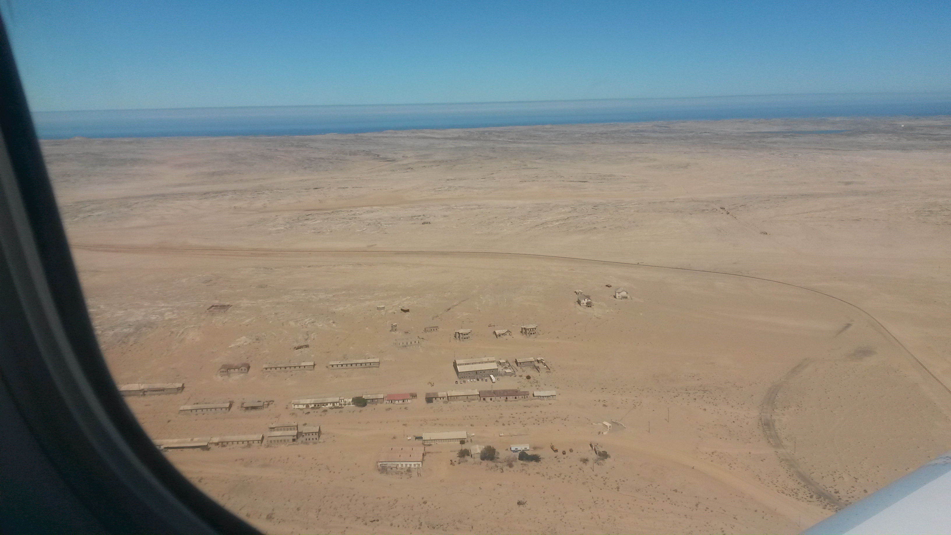
Today I want to share another view of the abandoned diamond mining town of Kolmanskop. I’m currently in Namibia for business, and I flew over Kolmanksop earlier today and managed to snap a few aerial pictures of the town with my phone. I previously visited Kolmanskop on the ground, and I shared some pictures here and here. However, I like these aerial views of Kolmanskop. They show the small buildings surrounded by a sea of sand, with the real sea sparkling blue on the horizon.
Kolmanksop from above #2, February 2015.Kolmanskop from above #3, February 2015.
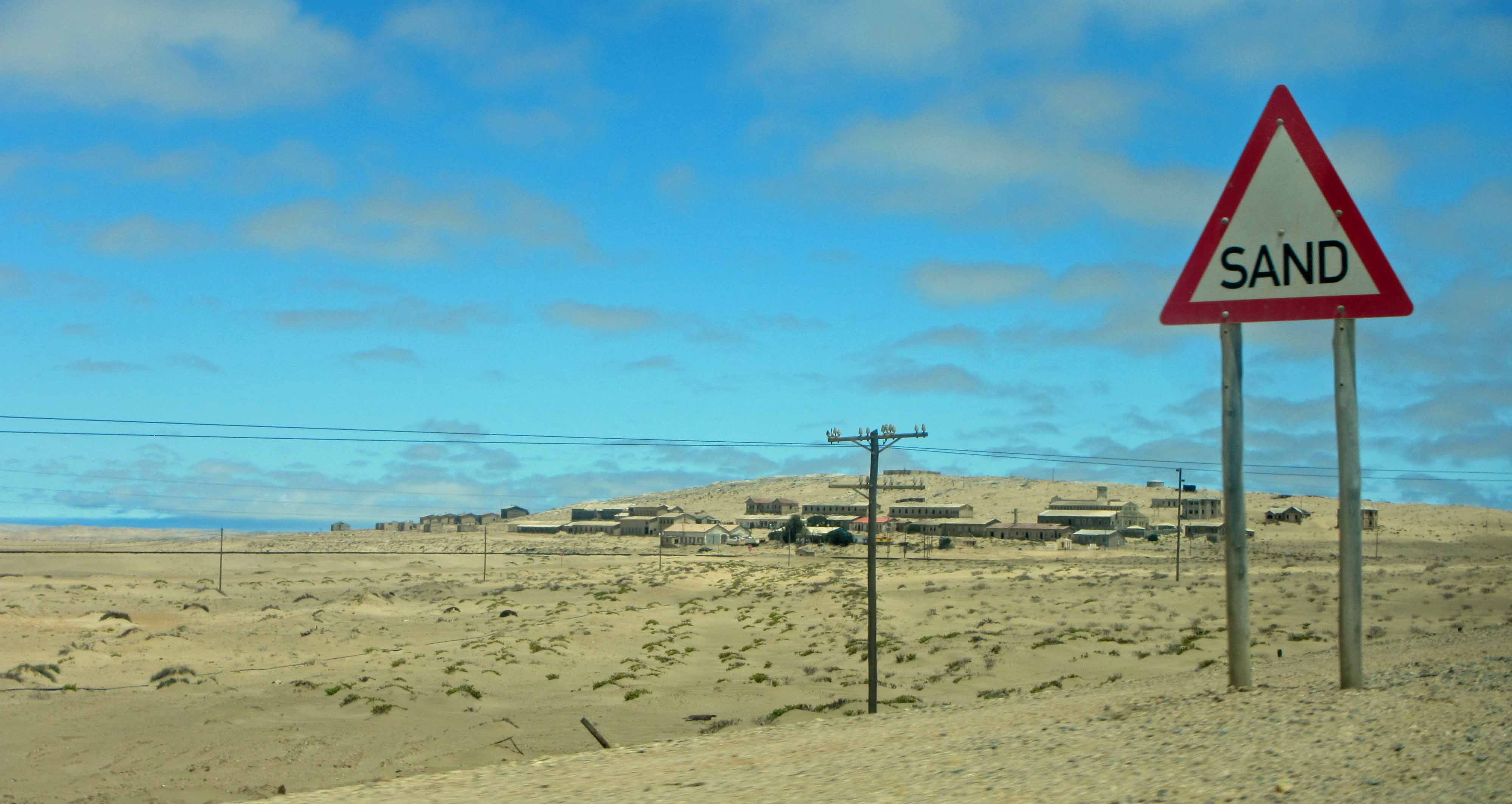
For this week’s “Monday Geology Picture” I’m sharing another picture from Kolmanskop, an abandoned diamond mining town in Namibia. Many of the buildings at Kolmanskop have been partially filled with sand. You can see more of my pictures from Kolmanskop here. When you drive along the paved road near Kolmanskop, you pass a roadside warning sign that says “Sand”. I suppose that the sign is warning drivers about sand covering the road or perhaps sandstorms creating poor visibility for driving, but when I saw the sign I thought that it was quite funny because it really states the obvious. Of course there is sand in the Namib Desert, especially at Kolmanskop!
Does anyone else have pictures of fun geologically themed roadsigns?