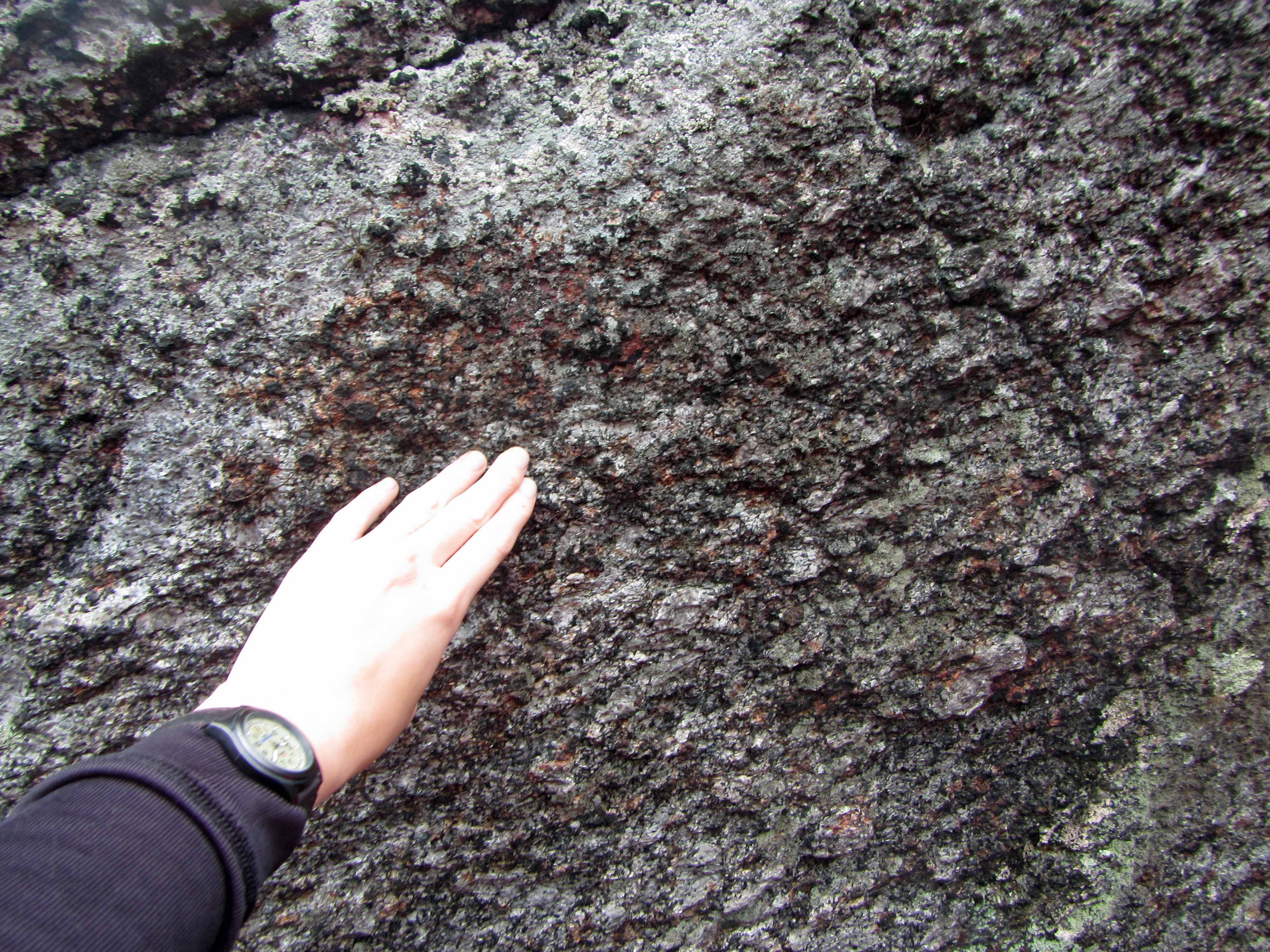
I’m visiting family in New Hampshire at the moment… and also spending a little time with my favorite glacial erratic. I’ve posted about this particular glacial erratic before here and here. For this week’s Monday Geology Picture post I thought I’d share another shot of this stunning glacially deposited boulder. Enjoy!
A U-shaped glacial valley on the Seward Peninsula outside of Nome, Alaska. Picture taken Summer 2013.
When glaciers erode landscapes, they often leave behind characteristic U-shaped valleys. This week’s Monday Geology Picture shows a U-shaped glacial valley on the Seward Peninsula in Alaska. This valley is located just outside of the gold mining town of Nome.
Does anyone else have good pictures of U-shaped valleys?
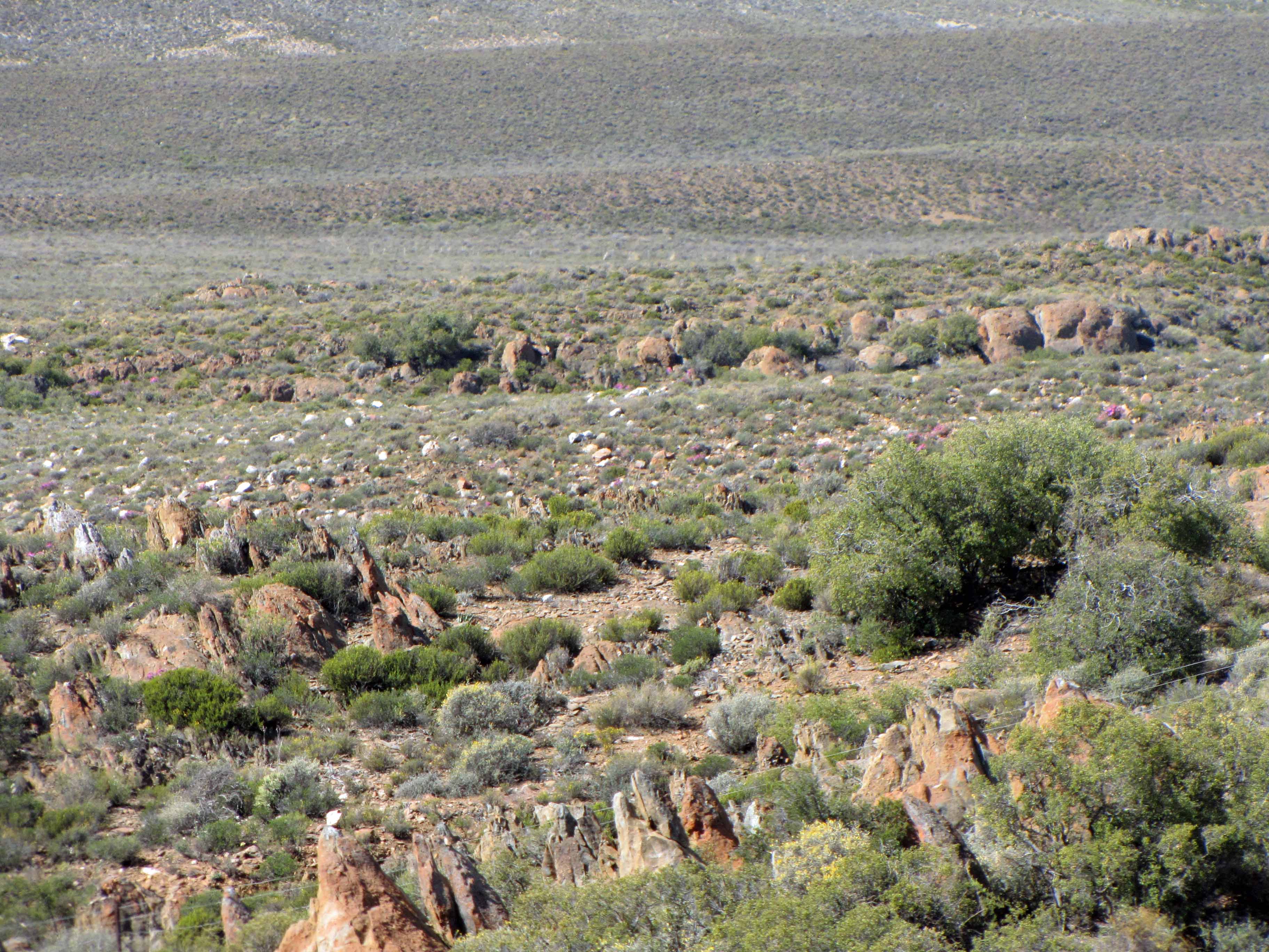
Dwyka diamictite can be recognised from a distance by its typical “tombstone” appearance, which forms during weathering.
At long last, I’m finishing up my series of posts about my October 2013 visit to the small town of Sutherland in South Africa’s Northern Cape province. Sutherland is home to a South African Astronomical Observatory (SAAO) research station that contains many telescopes, including the Southern African Large Telescope (SALT). You can read Part I of this series here, Part II of this series here, Part III of this series here, Part IV of this series here, and Part V of this series here. In my previous posts, I blogged about the astronomical observatory. In the last couple of posts, I’d like to blog about some of the geology that I observed on the drive from Cape Town to Sutherland.
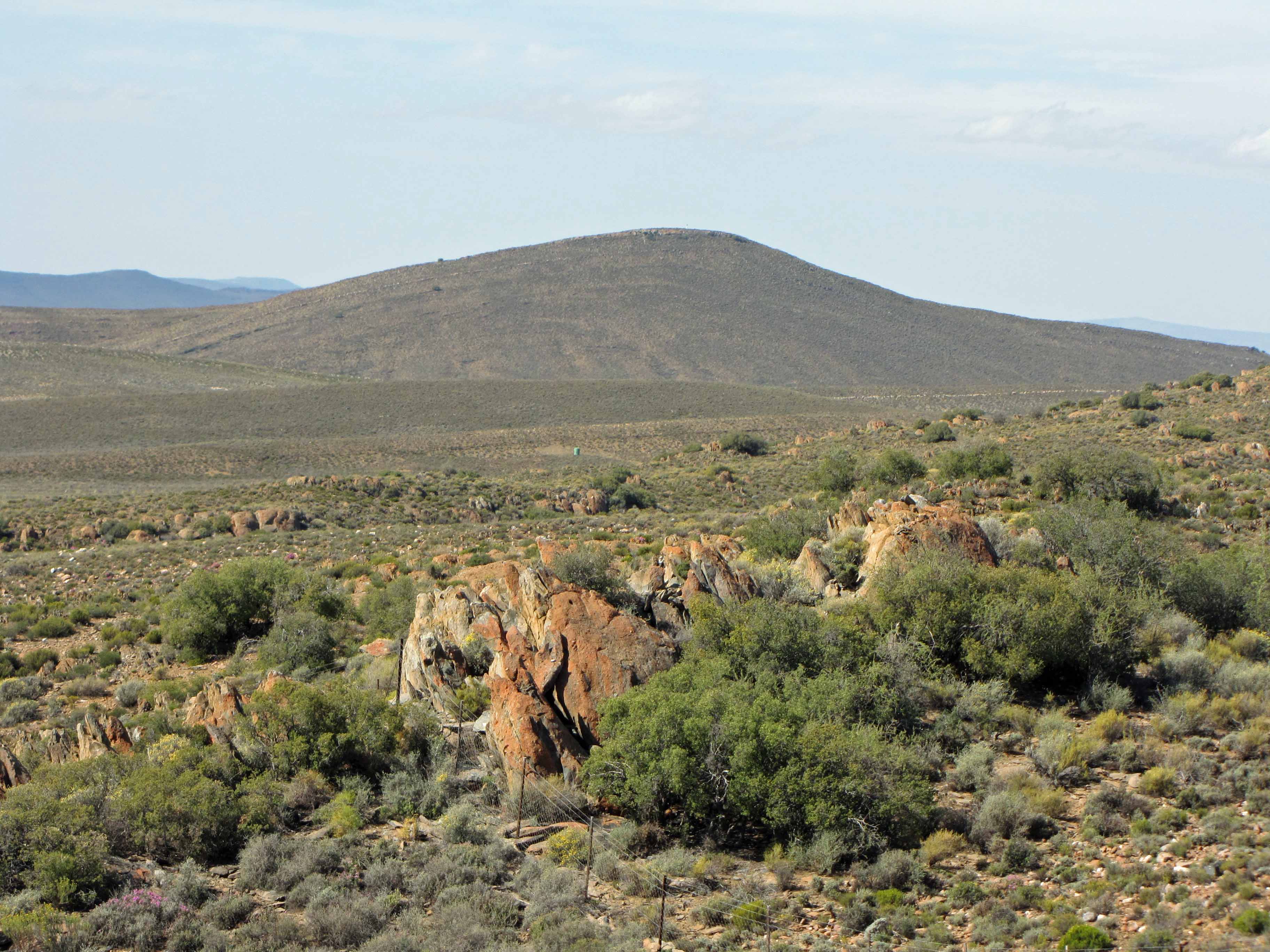
On the drive to Sutherland, we stopped at some fantastic roadcut exposures of Dwyka Group glacial sedimentary rock. Specifically, we stopped to look at some Dwyka diamictite, a term used to describe a poorly sorted sedimentary rock, commonly one deposited by a glacier. Dwyka glacial sediments are often referred to as “Dwyka tillite”. However, tillite is a specific term that refers to poorly-sorted sediments deposited directly underneath a glacier. Since there is evidence that many of the Dwyka glacial sediments were deposited in a glaciomarine environment, the term “Dwyka diamictite” is more accurate… and also has pleasing alliteration! Dwyka diamictite is Carboniferous in age and was left behind by a large glacier that covered southern Gondwana. Thus, Dwyka diamictite can be found on several continents and provides evidence that the supercontinent of Gondwana once existed.
Dwyka diamictite can easily be recognized from a distance by its distinctive “tombstone” appearance:
More “tombstone” weathering of Dwyka diamictite.
For some reason (perhaps one of my geomorphologist readers knows why?), the Dwyka tends to weather into “tombstone” shapes.
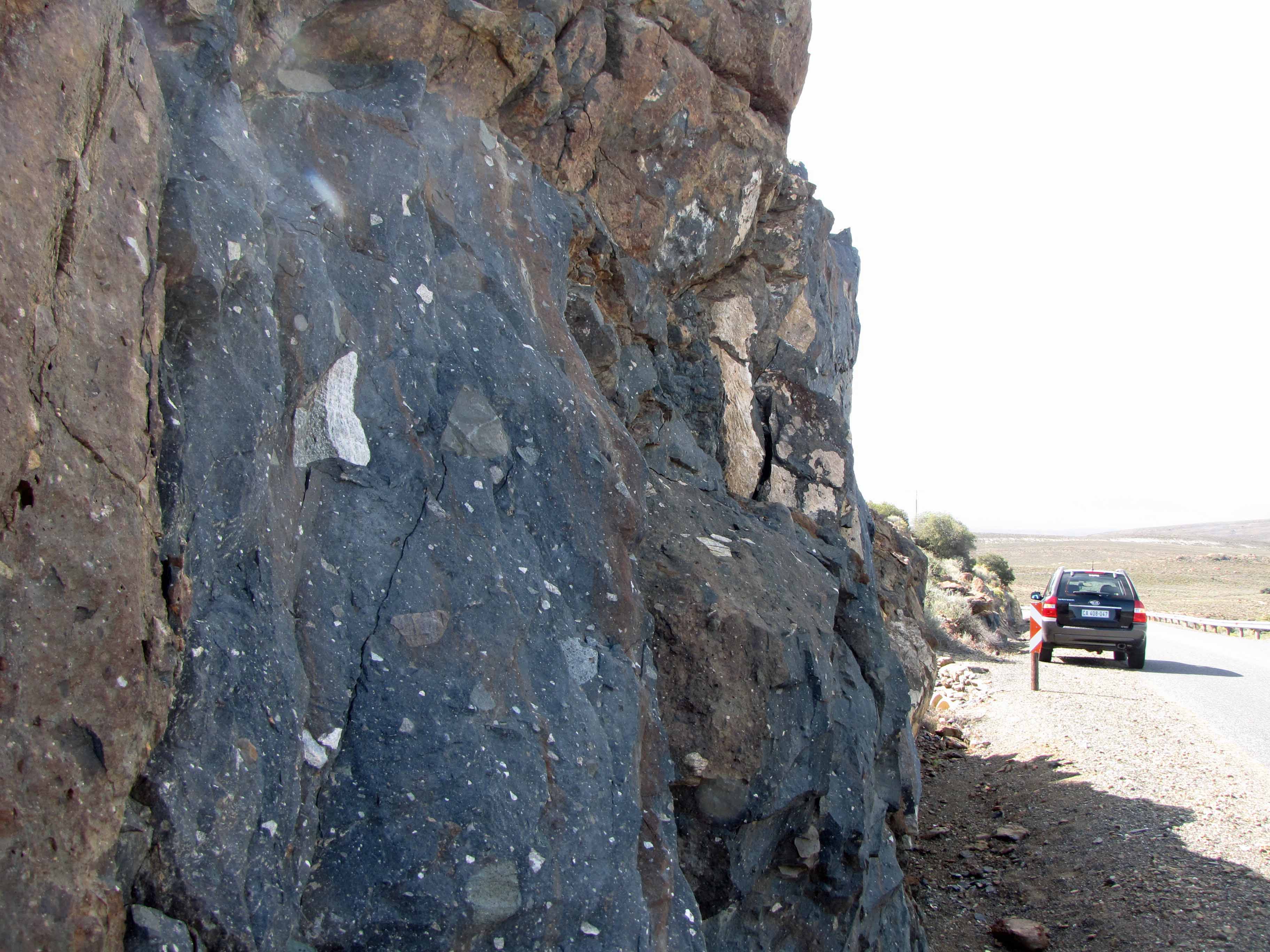
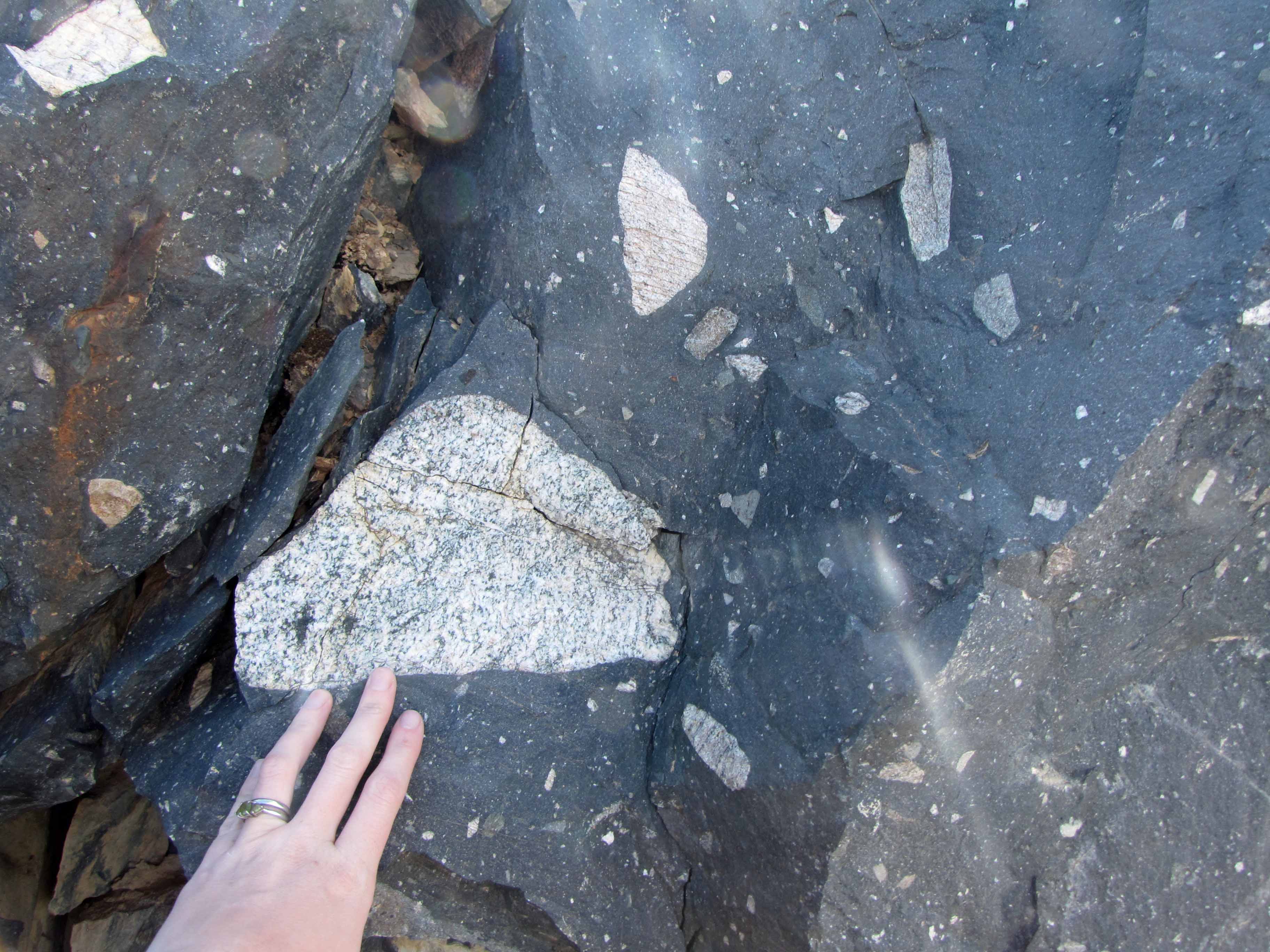
Dwyka diamictite is generally is covered in a reddish-brown oxidation rim. A fresh surface of Dwyka consists of a dark gray matrix (finer-grained glacial sediment) that contains clasts of all sizes, shapes, and rock types.
Here’s a look at a fresh roadcut surface of Dwyka diamictite:
Dwyka diamictite roadcut, with 4×4 for scale.Another view of the Dwyka diamictite outcrop.
I was really excited to take a look at such a beautiful roadcut of Dwyka diamictite:
Look! Dwyka diamictite!After several “Vanna White” shots, my husband made me take a “calmer” picture with the Dwyka diamictite outcrop.
Here are some pictures of some of the interesting clasts I saw in the Dwyka diamictite outcrop:
Dwyka diamictite clasts #1.Dwyka diamictite clasts #2.Dwyka diamictite clasts #3.Dwyka diamictite clasts #4.Dwyka diamictite clasts #5. That black and white clast is worth a closer look.Dwyka diamictite clasts #6.
How many of the above clasts can you identify? I see some igneous rocks, some sedimentary rocks, some metamorphic rocks… all sorts of rocks!
Well, that’s all for this “Sutherland Sky” post. Next I’ll share some pictures of some rocks I saw as we drove through the Cape Fold Belt on our way from Cape Town to Sutherland.
Majestic Blackstone Glacier. Picture courtesy of Jackie Gauntlett.
This week’s picture was taken by my husband Jackie in Prince William Sound, Alaska, back in early September. Jackie and I spent about two months working in Alaska earlier this year. After our work, I went to visit my family in New Hampshire for a few days while Jackie stayed behind with a colleague to pack up gear and such. Just before flying home to South Africa, Jackie and the colleague went on a glacier viewing cruise in Prince William Sound. They saw some impressive views of glaciers and highly recommend the cruise. I’m hoping to go on the cruise another year. Jackie tells me that the boat in the above picture above is bigger than it seems– Blackstone Glacier is quite a big glacier!
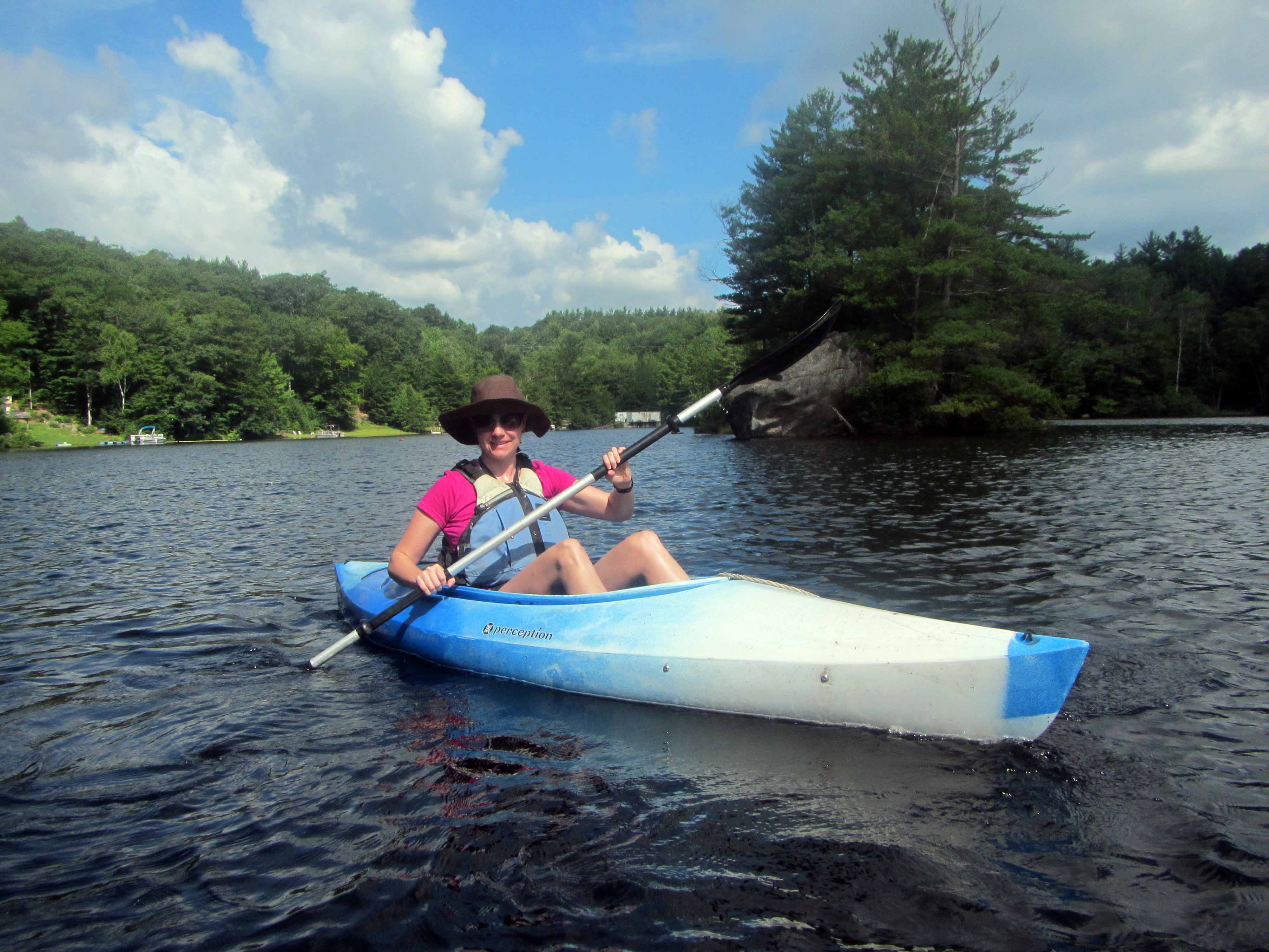
Setting off by kayak to explore the glacial erratics of Franklin Pierce Lake. Note the glacial erratic in the background.
Last week, I shared a picture of me sunbathing by my favorite glacial erratic, which is located near the Mervine Family Cabin on Franklin Pierce Lake in New Hampshire. This week, I thought I’d share a few more pictures of glacial erratics on Franklin Pierce Lake. Note the large sizes of these erratics and also how many of them are fairly angular. The erratics are mostly igneous and metamorphic rocks, and many of them contain large feldspar crystals.
I took all of the pictures in this post during a few kayaking trips during a recent visit to my family in New Hampshire. I really enjoy observing geology by kayak– I should do so more often!
My favorite glacial erratic, located on a little island near the Mervine Family Cabin.Some quite large erratic boulders!Angular erratic boulders. Note the front of my kayak for scale.Another view of an angular erratic boulder.A close-up view of the angular erratic boulder in the previous picture.Several erratic boulders.
I found this erratic boulder particularly interesting (note the large feldspar phenocrysts and interesting texture):
A particularly interesting erratic boulder. Check out those large feldspars!A closer view of the interesting erratic.
Brown and black products of Quaternary glaciovolcanic activity, with Paleozoic granite in the background, northern Victoria Land Antarctica. John Smellie for scale. Photo Credit: National Antarctic Research Program of Italy.
Note: Dr. Sergio Rocchi, an associate professor at the University of Pisa in Italy, presented a talk, “Intravolcanic sills, lava flows, and lava-fed deltas (Victoria Land, Antarctica): Paleoenvironmental Significance” at the LASI V workshop in Port Elizabeth, South Africa in October 2012. The article below is based on this talk and also an interview with Dr. Rocchi. Over a few weeks, I am highlighting some of the research that was presented at the LASI V workshop. This is the third post in that series.
When volcanoes erupt underneath and in the vicinity of glaciers and ice sheets, a unique geological record is created that provides information about both the volcanism and the snow and ice which interacted with the lava as it was being erupted. “Glaciovolcanism” is the term used to describe the interaction of lava with ice, snow (in all its forms, such as “firn” or compacted snow), and meltwater.
Glaciovolcanism includes study of modern examples in places such as Iceland and Antarctica as well as study of ancient examples. For the ancient examples, the ice and snow have generally long since melted away as a result of changing climate over the ages. Furthermore, the sediments and sedimentary rocks—tills and moraines and diamicts— associated with the glaciers and ice sheets have also often long since eroded away. However, volcanic rocks which interacted with the ice and snow are harder and slower to erode, and they often remain long after ice and sediment have disappeared.
Dissected late Pliocene volcano, northern Victoria Land Antarctica. John Smellie for scale. Photo Credit: National Antarctic Research Program of Italy.
Glaciovolcanic rocks can provide much valuable information about ancient glaciers and ice sheets. For example, study of glaciovolcanic rocks can help geologists identify if ice was present and, if so, can help geologists learn about the thickness of the ice, the elevation where the ice was present, the temperature conditions at the base of the ice, and the structure of the ice. A limitation is that volcanic eruptions do not occur continuously. Depending on the circumstances, they may occur at intervals of 10s—or even of 100s or 1000s— of years. Also, over time even hard glaciovolcanic rocks can erode away. Nevertheless, study of glaciovolcanic rocks is a powerful tool for reconstructing past ice cover and conditions, which in turn provides much information about past climate that can complement other paleoclimate studies—for example, study of sedimentary and coral records. Volcanic rocks are also fairly easy to date using isotopic techniques, so they can provide clear age constraints to help with paleoclimatic reconstructions.
Dr. Sergio Rocchi is a volcanologist who has studied glaciovolcanic rocks in Antarctica along with his colleague Dr. John Smellie and other co-workers. Dr. Rocchi explains, “Volcanic eruptions in subglacial environments generate some glacial volcanic lithofacies [units of rocks with certain characteristics] which can tell us the thickness and also the type of ice that was present at the time of the eruption. Additionally, the volcanic rocks can be dated by isotopic means, so the combination of the age and thickness of the ice can be a very useful source of paleoenvironmental information.”
Sergio Rocchi flying over Mt Melbourne Volcano, northern Victoria Land Antarctica. Photo credit: National Antarctic Research Program of Italy.Sergio Rocchi over Campbell Glacier, northern Victoria Land Antarctica. Photo credit: National Antarctic Research Program of Italy.
As an example, Dr. Rocchi and his co-workers have studied Late Miocene glaciovolcanic rocks of Victoria Land, Antarctica. There, hyaloclastite-rich glaciovolcanic rocks, including some “lava-fed deltas” (features which form when lava enters water either in a marine/lacustrine or a glacial meltwater environment), have enabled reconstruction of Late Miocene glacial cover over Victoria Land. The glaciovolcanic rocks indicate that at this time Victoria Land was covered by a thin (<300 m thick) cover of ice. This ice sheet is much thinner than that predicted by some modeling studies and implies a more complex climatic transition in the Miocene than previously thought.
While most work regarding glaciovolcanism to date has been carried out in Antarctica, study of glaciovolcanism can also be done in many other places. “Similar work can obviously been done wherever there are or were volcanoes and ice,” says Dr. Rocchi. “The main places where volcano-ice interaction can be studied are Antarctica, Iceland, and British Columbia in the northern Cascades. A future project for which we are raising funding is making a comparison of the glaciovolcanic record in Antarctica with that in Iceland.”
In the future, study of glaciovolcanism will no doubt continue to help geologists and climate scientists unravel the history and nature of past glaciers and ice sheets. Combined with other paleoclimate records, study of glaciovolcanism will help scientists to better understand how Earth’s climate used to be and how climate changes over time. This information is invaluable in a time when humans are experiencing the effects of anthropogenic climate change and when scientists need as much information as possible in order to evaluate what may happen to Earth’s climate in the coming years.
Smellie, J., Wilch, T., and Rocchi, S., 2013. ‘A‘ā lava-fed deltas: A new reference tool in paleoenvironmental studies. Geology. (to be published in the April issue).
Smellie, J., Rocchi, S., and Armienti, P. 2011. Late Miocene volcanic sequences in northern Victoria Land, Antarctica: products of glaciovolcanic eruptions under different thermal regimes. Bulletin of Volcanology, Vol. 73: 1-25.
Smellie, J., Rocchi, S., Gemelli, M., Di Vincenzo, G., and Armienti, P. 2011. A thin predominantly cold-based Late Miocene East Antarctic ice sheet inferred from glaciovolcanic sequences in northern Victoria Land, Antarctica. Palaeogeography, Palaeoclimatology, Palaeoecology, Vol. 307: 129-149.
Smellie, J., Johnson, J., McIntosh, W., Esser, R., Gudmundsson, M., Hambrey, M., van Wyk de Vries, B. 2008. Six million years of glacial history recorded in volcanic lithofacies of the James Ross Island Volcanic Group, Antarctica Peninsula. Palaeogeography, Palaeoclimatology, Palaeoecology, Vol. 260: 122-148.
Me, standing on top of a glacial erratic boulder in Nome, Alaska, Summer 2012.
def. Glacial Erratic:
A rock which has been transported and deposited by a glacier and which has a different lithology than the rock upon which it has been deposited. Often, erratic rocks have an angular shape because they were broken off of bedrock by glaciers and have not yet had time to be weathered and rounded by water, wind, and other erosional forces. Glacial erratics can range in size from very small pebbles to very large boulders, but usually it is the boulders which are noticed since these stand out in the landscape and are not easily transported away again.
Recently, I have been thinking a fair amount about glacial erratics and other glacial rocks and deposits, such as tills and moraines. That’s because I currently work for a marine gold exploration company that has a project offshore Nome, Alaska, where glaciers have transported gold to the coast along with erratics and other glacial sediments. If you walk along the beaches of Nome, you can spot quite a few glacial erratics, such as the one I’m standing upon in the above picture.
Another glacial erratic on the beach in Nome, Alaska, Summer 2012. Pen for scale.
Having grown up in New England, I’m no stranger to glacial erratics. In fact, back in September I wrote a little about my favorite glacial erratic, which sits on an island in front of my parents’ lakeside cabin in New Hampshire.